Supercharge Your Innovation With Domain-Expert AI Agents!

A Fusion Filtering Method for UAV Remote Sensing Mountain Highway Image

A technology of image fusion and machine-based remote sensing, applied in the field of image processing, can solve problems such as block effect, uncertain filter output, and inability of filter to accurately reflect edge information, etc., to achieve suppression of block effect, clean noise filtering, and filtering effect Good results

Active Publication Date: 2021-07-23
北京时空天地科技有限公司 +1
View PDF9 Cites 0 Cited by
  • Summary
  • Abstract
  • Description
  • Claims
  • Application Information

AI Technical Summary

Problems solved by technology

Kuwahara filter is a nonlinear filter that divides the rectangular area centered on the pixel point x into four sub-squares, calculates the mean and variance of these four sub-areas, and outputs the mean value of the sub-block with smaller variance, but This filter cannot accurately reflect the edge information of areas with larger edge curvature or more information in the image, as well as the influence of the Gibbs effect, resulting in block effects in the output image
In addition, when there are two or more sub-regions with the smallest standard deviation at the same time, resulting in uncertain output of the filter, there is still a large room for improvement

Method used


Image

  • A Fusion Filtering Method for UAV Remote Sensing Mountain Highway Image
  • A Fusion Filtering Method for UAV Remote Sensing Mountain Highway Image
  • A Fusion Filtering Method for UAV Remote Sensing Mountain Highway Image

Examples


Embodiment Construction

[0043] Below in conjunction with accompanying drawing, the present invention is described in further detail:

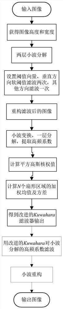
[0044] see figure 1 , a kind of unmanned aerial vehicle remote sensing mountain road image fusion filtering method, comprises the following steps:

[0045] Step 1: Obtain the image of the road in the mountainous area remotely sensed by the UAV;

[0046] Step 2: Use wavelet function to decompose the remote sensing image obtained in step 1 into two layers of wavelet;

[0047] Step 3: Set the threshold vector, and perform soft threshold filtering in the horizontal, vertical, and diagonal directions on the high-frequency coefficients obtained in step 2, where the vertical direction is filtered twice, and the other directions are filtered once;

[0048] Step 4: carry out wavelet reconstruction to the image after step 3 filtering;

[0049] Step 5: Decompose the reconstructed image into one layer of wavelet; obtain high-frequency coefficients in three directions; filter i...


PUM


Abstract

The invention discloses a method for filtering images of roads in mountainous areas remotely sensed by drones, which acquires road images in mountainous areas sensed by drones; uses wavelet functions to perform two-layer wavelet decomposition on the remote sensing images obtained in step 1; sets threshold vectors, respectively Soft-threshold filtering is performed on the high-frequency coefficients in the vertical and diagonal directions, where the vertical direction is filtered twice, and the other directions are filtered once; the filtered image is reconstructed by wavelet; the image obtained in the previous step is decomposed by wavelet layer, And use the improved Kuwahara filter to filter the high-frequency coefficients; reconstruct the filtered image to obtain the final image. Based on the wavelet transform, the invention adopts the improved Kuwahara filter for filtering, can filter out the Gaussian noise in the image, and has good edge detail information protection performance.

Description

technical field [0001] The invention belongs to the technical field of image processing, and in particular relates to an image fusion and filtering method for remote sensing of mountainous roads by an unmanned aerial vehicle. Background technique [0002] With the rapid development of modern aerospace and UAV technology, remote sensing technology has made rapid progress. The processing and analysis of remote sensing mountain road images collected by drones has become a research hotspot at home and abroad in recent years. [0003] However, due to the influence of sensors and mountain environment, the images of remote sensing mountain roads are disturbed by various noises in the process of collection, transmission and storage, which is not conducive to the further processing and analysis of useful information in remote sensing images. In order to obtain clear and accurate image information of remote sensing mountain roads, the research on denoising algorithm, as a basic image...

Claims


Application Information

Patent Timeline
Patent Type & Authority Patents(China)
IPC IPC(8): G06T5/00
CPCG06T5/70
Inventor 黄鹤李昕芮茹锋郭璐许哲宋京黄莺惠晓滨王会峰王萍王成壮何永超胡凯益任思奇程慈航
Owner 北京时空天地科技有限公司
Features
  • R&D
  • Intellectual Property
  • Life Sciences
  • Materials
  • Tech Scout
  • Unparalleled Data Quality
  • Higher Quality Content
  • 60% Fewer Hallucinations
Learn More