Multisource perception positioning system suitable for smart networked car

A positioning system and source-aware technology, applied in the direction of measuring devices, instruments, surveying and navigation, etc.

Inactive Publication Date: 2019-03-01
武汉契友科技股份有限公司
View PDF4 Cites 91 Cited by
  • Summary
  • Abstract
  • Description
  • Claims
  • Application Information

AI Technical Summary

Problems solved by technology

[0017] In order to solve the above technical problems, this paper involves environmental perception technology, visual SLAM and closed-loop fusion positioning technology, GNSS/inertial integrated navigation and positioning technology, high-precision map production technology, multi-source perception fusion positioni

Method used


Image

  • Multisource perception positioning system suitable for smart networked car
  • Multisource perception positioning system suitable for smart networked car
  • Multisource perception positioning system suitable for smart networked car

Examples


Embodiment Construction

[0049] In order to have a clearer understanding of the technical features, purposes and effects of the present invention, the specific implementation of the present invention will now be described in detail with reference to the accompanying drawings.

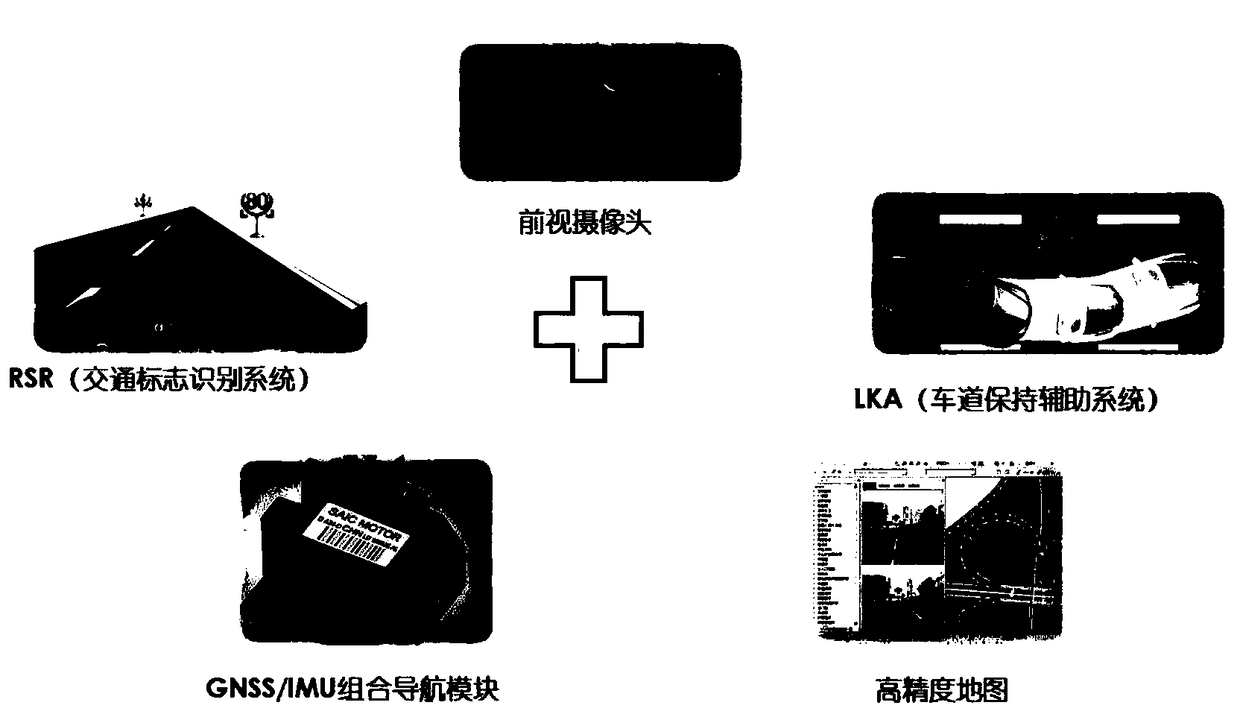
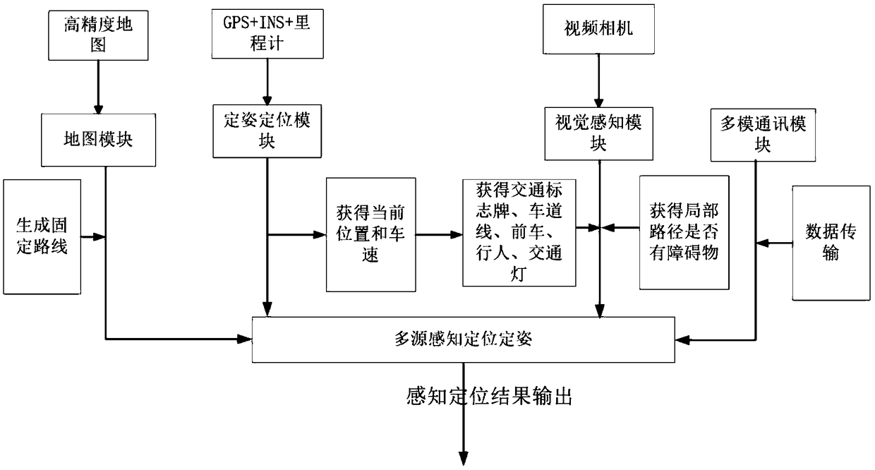
[0050] refer to figure 1The hardware part of the multi-source perception navigation and positioning system includes a front-view camera, GNSS / IMU integrated navigation component, LTE multi-mode communication component, multi-source data fusion processing component and odometer, and the software part includes high-precision maps and real-scene image maps, hardware and software See the information flow chart for the relationship between data and data, that is, figure 2 shown.

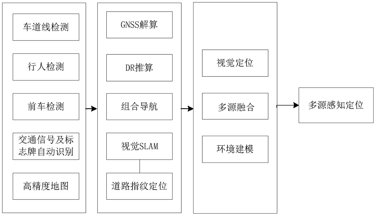
[0051] In addition to the high-precision positioning function, the multi-source perception navigation and positioning system block also has lane line detection, pedestrian detection, front vehicle detection, traffic signal and sign automatic recognition,...


PUM


Abstract

A multisource perception positioning system suitable for smart networked car. In a multisource perception navigation positioning system, a hardware portion includes a front camera, a GNSS and IMU combined navigation module, a LTE multimode communication module, a multisource data fusion processing module and a speedometer, and a software portion includes a data portion comprising a map and a realscene image. The multisource perception navigation positioning system includes: a positioning module, a lane line detection module, a pedestrian detection module, a preceding car detection module, a traffic signal and sign auto-recognition module, a GNSS calculating module, a DR calculating module, a combined navigation module, a visional SLAM module, a road fingerprint positioning module, and a multisource fusion perception positioning module. In the invention, environment perception technology, visional SLAM and closed loop fusion positioning technology, GNSS/inertial integrated navigation positioning technology, high-precision map making technology and multisource fusion perception positioning technology are combined, thus solving the problem of high-precision positioning of the smart networked car under urban complex road situation and losing lock condition in an underground garage.

Description

technical field [0001] The present invention relates to the technical field of navigation, and more specifically, relates to a multi-source perception positioning system suitable for intelligent networked vehicles. Background technique [0002] Traditional navigation and positioning technology means include satellite positioning, inertial positioning, visual positioning, radio positioning and other active or passive navigation and positioning means. The test of complex actual working conditions has brought a series of impacts on the use conditions of the device, such as multi-path interference of satellite navigation signals, inertia calculation accuracy maintenance under weak and no satellite signal conditions, light changes, occlusion, and reflections on the ground of the parking lot, etc. These are all challenges for sensor algorithms. [0003] (1) Environmental perception technology [0004] As an intelligent driving safety auxiliary device, the on-board camera is like...

Claims


Application Information

Patent Timeline
IPC IPC(8): G01C21/16
CPCG01C21/165
Inventor 伍桂玉
Owner 武汉契友科技股份有限公司
Why Eureka
Try Eureka