Supercharge Your Innovation With Domain-Expert AI Agents!

A remote sensing data analysis method based on depth learning

A technology of remote sensing data and analysis methods, which is applied in the fields of instruments, character and pattern recognition, computer parts, etc., can solve the problems of low classification accuracy and large influence on the classification accuracy of the number of member models, so as to improve the efficiency and improve the classification accuracy. Accuracy, the effect of reducing the number of samples

Inactive Publication Date: 2019-03-08
成都国星宇航科技股份有限公司
View PDF4 Cites 11 Cited by
  • Summary
  • Abstract
  • Description
  • Claims
  • Application Information

AI Technical Summary

Problems solved by technology

[0005] However, the above method still has the shortcomings of low classification accuracy and the number of member models has a greater impact on classification accuracy.

Method used


Image

  • A remote sensing data analysis method based on depth learning
  • A remote sensing data analysis method based on depth learning
  • A remote sensing data analysis method based on depth learning

Examples


Embodiment Construction

[0029] The present invention will be further described below in conjunction with the accompanying drawings and embodiments.

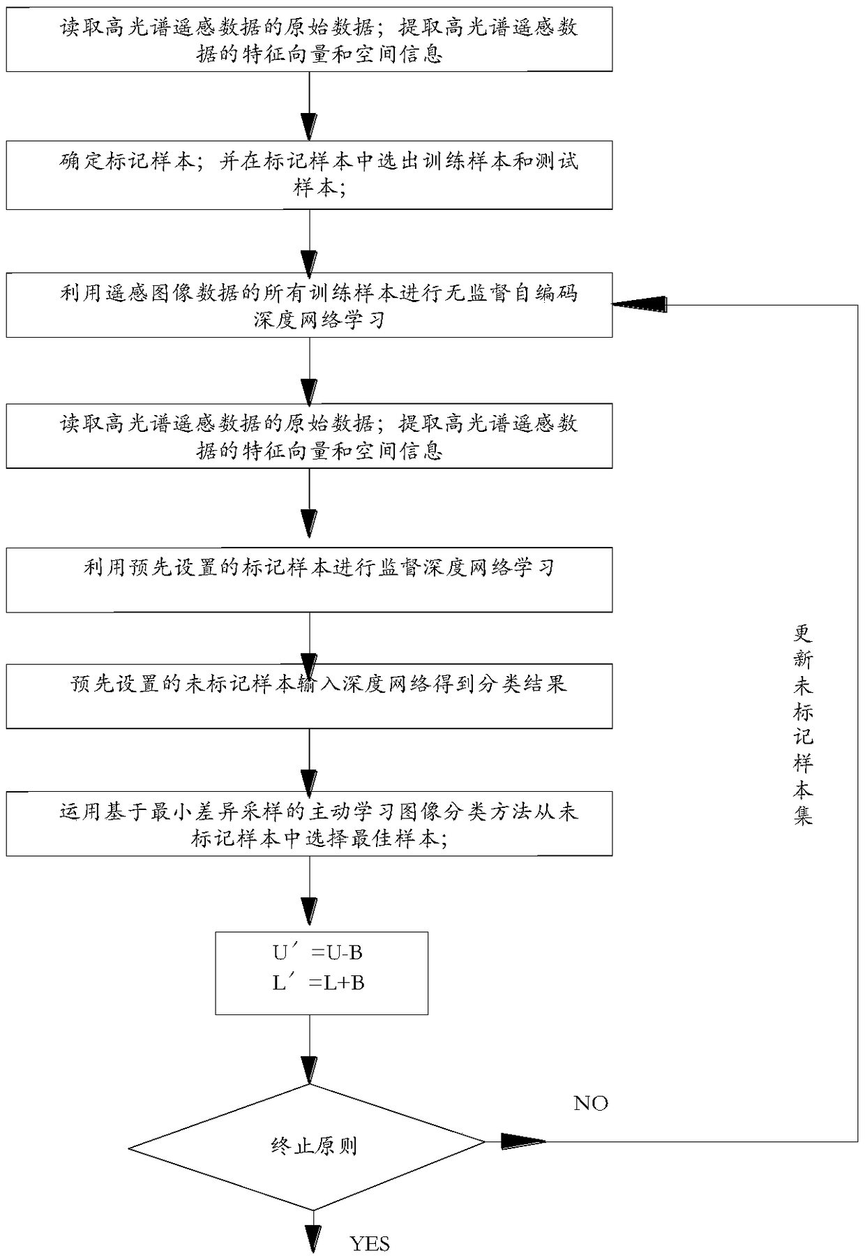
[0030] like figure 1 As shown, a remote sensing data analysis method based on deep learning includes the following steps:

[0031] 1) Read the original data of hyperspectral remote sensing data; perform data preprocessing operations to reduce data dimensions; build a basic deep belief network model to extract feature vectors and spatial information of hyperspectral remote sensing data;

[0032] 2) by the eigenvector and the spatial information of the hyperspectral remote sensing data extracted in step 1), determine the marked sample; And select the training sample and the test sample in the marked sample;

[0033] 3) Use all training samples of remote sensing image data for unsupervised self-encoding deep network learning;

[0034] 4) Then use the pre-set labeled samples for supervised deep network learning;

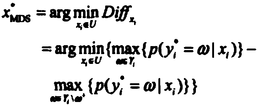
[0035] 5) Use the pre-set unlabeled samp...


PUM


Abstract

The invention discloses a remote sensing data analysis method based on depth learning, which can further improve classification accuracy and reduce the influence of the number of member models on classification accuracy. The method comprises the following steps of 1) reading the original data of the hyperspectral remote sensing data; 2) determining a marking sample; and selecting training samplesand test samples from the marked samples; 3) carrying out unsupervised self-coding depth network learning on all train samples; 4) marking samples for supervise in-depth network learning; 5) inputtingthat unlabeled samples into the depth network to obtain a classification result; 6) selecting the best sample from the unlabeled samples by using the active learning image classification method basedon the least difference sampling; 7) labeling the samples selected by active learning, deleting the samples from the unlabeled samples, adding the unlabeled samples into the training samples, updating the training samples, and obtaining the final classifier; 9) evaluating the accuracy of the classification results. By sampling the method, the classification accuracy and the classification efficiency can be improved.

Description

technical field [0001] The invention relates to the field of analysis of remote sensing data, in particular to a remote sensing data analysis method based on deep learning. Background technique [0002] The remote sensing data source is a series of ground object spectral data with different wavelengths obtained through active or passive remote sensors. After the obtained ground feature spectral data is converted into digital data, it can be used in geographic information system. [0003] Most Landsat scanners are typically spectral scanners, a linear array of devices. The scanner acquires ground data by reciprocating scanning (such as LANDSAT) or advancing scanning (such as SPOT). These scanners passively record the solar spectrum reflected from the earth's surface, such as multispectral scanning data can extract crop type, distribution and growth, topography, soil, water surface and river network information. Infrared scanners can record thermal radiation data emitted by...

Claims


Application Information

Patent Timeline
IPC IPC(8): G06K9/62G06K9/66
CPCG06V30/194G06F18/2411G06F18/214
Inventor 熊文轩周舒婷王珑
Owner 成都国星宇航科技股份有限公司
Features
  • R&D
  • Intellectual Property
  • Life Sciences
  • Materials
  • Tech Scout
  • Unparalleled Data Quality
  • Higher Quality Content
  • 60% Fewer Hallucinations
Learn More