Unknown terrain navigation system based on image processing and method

An image processing and navigation system technology, applied in the field of intelligent robots, to achieve the effect of complete search work and navigation sharing

Pending Publication Date: 2019-04-05
BEIHANG UNIV
View PDF8 Cites 4 Cited by
  • Summary
  • Abstract
  • Description
  • Claims
  • Application Information

AI Technical Summary

Problems solved by technology

[0004] In order to solve the problem that path planning in unknown terrain needs to be explored in advance, the present invention provides an unknown te

Method used


Image

  • Unknown terrain navigation system based on image processing and method
  • Unknown terrain navigation system based on image processing and method
  • Unknown terrain navigation system based on image processing and method

Examples


Embodiment Construction

[0036] The following will clearly and completely describe the technical solutions in the embodiments of the present application with reference to the accompanying drawings in the embodiments of the present application. Obviously, the described embodiments are only for illustration, and are not intended to limit the present application.

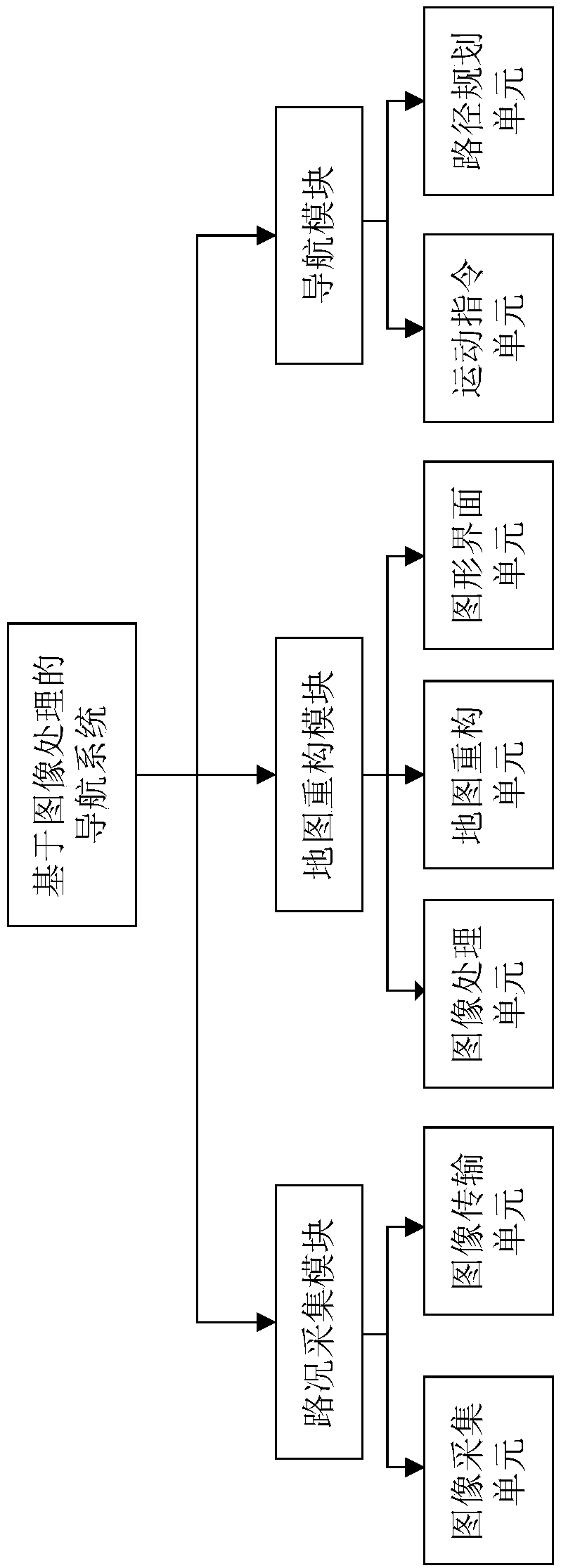
[0037] figure 1 It is a block diagram of the unknown terrain navigation system based on image processing of the present invention, including a road condition collection module, a map reconstruction module and a navigation module. The road condition acquisition module includes an image acquisition unit and an image transmission unit, wherein the image acquisition unit is composed of a monocular CMOS camera to realize the acquisition of image information; the image transmission unit includes serial port communication and wireless LAN communication, and the serial port communication transfers the information collected by the monocular CMOS camera ...


PUM


Abstract

The invention provides an unknown terrain navigation system based on image processing. The system comprises a road condition acquisition module, a map reconstruction module, and a navigation module. The road condition acquisition module comprises a monocular vision camera and an image transmission unit. The map reconstruction module comprises an image processing unit and a map reconstruction unit.The navigation module comprises a motion instruction unit and a path planning unit. The image transmission unit transmits local road conditions images acquired by the camera in real time to the imageprocessing unit. The image processing unit extracts road route features in the local road conditions. The map reconstruction unit continuously reconstructs the map according to the extracted road route features until the global map is reconstructed. The motion instruction unit sends motion instruction information to a mobile platform according to the reconstructed map. The invention further provides a navigation method based on the system. The navigation sharing system for the unknown terrain has the characteristics of being simple in structure, low in cost, and easy to realize learning and upgrading.

Description

technical field [0001] The present application relates to the field of intelligent robots, specifically but not exclusively, to a sharable unknown terrain navigation system and method based on image processing. Background technique [0002] The navigation system based on image processing is an industry with broad application prospects, in which mobile robots have been widely used in many fields such as production and processing, logistics, and scientific research. The substantial increase in computer computing power has also greatly improved the efficiency of processing the rich information collected by visual sensors. The navigation system of visually assisted mobile robots has received widespread attention, such as in various known or unknown scenes. , using monocular or binocular vision to help mobile robots complete autonomous obstacle avoidance and even path planning tasks. [0003] However, in an unknown terrain, mobile robots need to explore in advance to determine t...

Claims


Application Information

Patent Timeline
IPC IPC(8): G01C21/34G01S17/93G06K9/00
CPCG01C21/3446G01S17/931G06V20/10G06V20/56
Inventor 刘晓锋熊刘琦付家琪罗晨爽张哲源孙旭吴彦琛
Owner BEIHANG UNIV
Why Eureka
Try Eureka