Spatial data construction method, device and equipment and storage medium

A spatial data and spatial technology, applied in the field of geographic information systems, can solve problems such as different formats, repeated content, and different types, and achieve the effect of high practicability and wide application range

Inactive Publication Date: 2019-04-26
广东启慧城市信息有限公司
View PDF8 Cites 11 Cited by
  • Summary
  • Abstract
  • Description
  • Claims
  • Application Information

AI Technical Summary

Problems solved by technology

However, the data collected from different channels may have shortcomings such as different formats, different types, and repeated content, which greatly increases the difficulty of building a spatial database.

Method used


Image

  • Spatial data construction method, device and equipment and storage medium
  • Spatial data construction method, device and equipment and storage medium
  • Spatial data construction method, device and equipment and storage medium

Examples


Embodiment Construction

[0024] The application will be further described in detail below in conjunction with the accompanying drawings and embodiments. It should be understood that the specific embodiments described here are used to explain the present application rather than limit the present application. In addition, it should be noted that, for the convenience of description, only some structures related to the present application are shown in the drawings but not all structures.

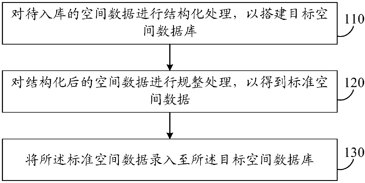
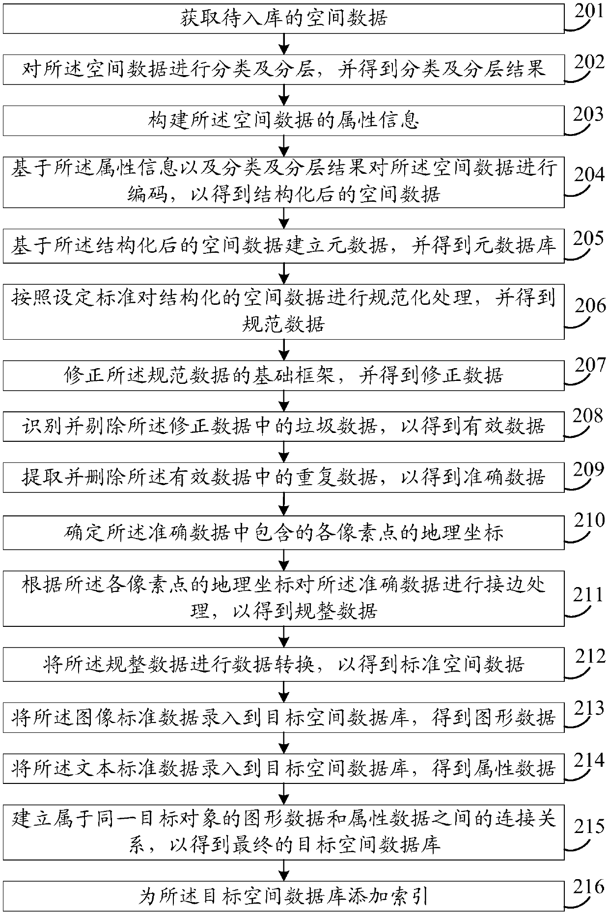
[0025] figure 1 It is a flow chart of a spatial data construction method provided by the embodiment of the present application. The spatial data construction method can be executed by a spatial data construction device. The spatial data construction device can be realized by software and / or hardware, and integrated in the spatial data building equipment. Among them, the spatial data construction equipment includes but is not limited to smart devices such as desktop computers, notebook computers, and tablet computers. ...


PUM


Abstract

The embodiment of the invention discloses a spatial data construction method and device, equipment and a storage medium, and the method comprises the steps: carrying out the structured processing of to-be-stored spatial data, so as to build a target spatial database, and enabling the type of the spatial data to comprise the image data of a target object and the text data of the target object; Performing regularization processing on the structured spatial data to obtain standard spatial data, the standard spatial data being data conforming to a warehousing standard; And inputting the standard spatial data into the target spatial database. By adopting the technical scheme, the construction process of the spatial database can be optimized; When spatial data types are diverse, it can be guaranteed that the spatial data are scientifically and systematically input into the target spatial database through structured processing and regularization processing, the application range is wide, thepracticability of the target spatial database is high, and a user can conveniently read, write, browse and search the spatial data in the target spatial database subsequently.

Description

technical field [0001] The embodiments of the present application relate to the technical field of geographic information systems, and in particular to a spatial data construction method, device, equipment, and storage medium. Background technique [0002] Geographic Information System (GIS) is a computer-based tool that can analyze and process spatial information. GIS technology integrates the unique visual effects and geographic analysis functions of maps with general database operations (such as query and statistical analysis, etc.). Spatial database refers to the sum of application-related geospatial data stored in computer physical storage media by geographic information system. [0003] In order to ensure the accuracy and richness of the data in the spatial database, a large amount of data needs to be collected in the early stage. However, data collected from different channels may have shortcomings such as different formats, different types, and repeated content, wh...

Claims


Application Information

Patent Timeline
Patent Type & Authority Applications(China)
IPC IPC(8): G06F16/29
Inventor 熊友谊张文金王勇熊四明张孝文
Owner 广东启慧城市信息有限公司
Why Eureka
Try Eureka