[0006] The principle of MR-based fingerprint
positioning technology is: divide the actual map into continuous square grids according to a certain distance, and then drop a large number of MR data points containing
latitude and
longitude into the grids according to the
latitude and
longitude, and extract the information in each grid The features are built into an MR fingerprint
library; the process of locating a certain MR
record is to extract the features of this MR data, and then compare it with the features of each grid in the existing
library to calculate the
Euclidean distance, and use the grid with the smallest distance grid as the grid to which this piece of MR data is positioned, and the center point of the grid is used as the longitude and latitude of positioning; Limited, the main defects and deficiencies are as follows:
[0007] In the construction process of traditional positioning products or platforms based on the principle of
fingerprint database, the method of data drop point is only to directly fall into the corresponding grid according to the latitude and longitude. However, the latitude and longitude data reported in the actual operator data is not accurate enough, and even a large part is The error is very large, and directly falling into the corresponding grid according to the erroneous latitude and longitude will cause the actual
data point to fall into the wrong grid, which will cause serious interference in the extraction of features and positioning of the subsequent
database construction, which will greatly affect the fingerprint. Location Accuracy of Libraries
[0008] In the construction process of traditional positioning products or platforms based on the principle of
fingerprint database, the existing technology divides the map into regular grids of the same size. The actual geographical conditions in a grid are complex and may cover subways, roads, elevated, irregular Various environments such as buildings and outdoors will cause large changes in
signal characteristics, which will affect the accuracy of
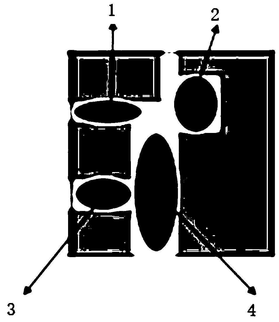
database construction; taking buildings as an example, such as figure 1 Shown: figure 1 Among them, the signal characteristics of areas 1, 2, 3, and 4 will be significantly different, and the fingerprint
library built based on the signal characteristics in this grid will inevitably cause positioning errors; if the grid is divided into smaller and finer, theoretically no matter No matter how small the grid is, this situation exists, and it can be avoided to a certain extent, but it cannot be completely avoided, but the smaller the grid division, the difficulty in building the database and the efficiency of positioning will inevitably occur (because the database is too large, the number of comparisons will increase). It has an exponential
impact, and because it is too detailed, it may also lead to
distortion of the actual built library, and poor positioning effect and accuracy
[0009] In the process of updating and optimizing traditional positioning products or platforms based on the principle of
fingerprint database, the optimization of the original fingerprint database is mostly based on manual search for errors with poor accuracy, which consumes a lot of manpower and the effect is not ideal; In changing, it is further required that the fingerprint database should be updated in time. The existing update method is to accumulate data for a period of time, and then re-build the database. The update cycle is long and needs to be re-optimized after the database is built; the entire reconstruction and optimization process is repeated in use. It consumes a lot of manpower and
material resources with low efficiency and poor effect; and after each optimization, some libraries with accurate positioning cannot be maintained, and
continuous optimization iterations cannot be achieved, resulting in the inability to achieve more accurate positioning effects
[0010] In the application process of traditional positioning products or platforms based on the principle of fingerprint library, when the actual application needs to know whether the user's location belongs to the road or in the building, a grid may include roads, buildings, other areas, etc., representing the user The actual location may also belong to any one of these types of areas, but at present, it can only be judged based on the returned center point. Obviously, there are errors, which lead to the failure of many subsequent applications.

