full-automatic orthographic image splicing method based on a GPS ground control point

A technology of ground control points and orthophotos, applied in image data processing, graphic image conversion, instruments, etc., can solve the problems of prone to human error and cumbersome stitching process.

Active Publication Date: 2019-05-24
SOUTHEAST UNIV
View PDF2 Cites 5 Cited by
  • Summary
  • Abstract
  • Description
  • Claims
  • Application Information

AI Technical Summary

Problems solved by technology

[0005] Aiming at the cumbersome process of stitching images taken by drones and prone to human errors, this invention proposes a fully automatic orthophoto stitching method based on GPS ground control points, setting control points on the ground, measuring the coordinates of the control points and sending For UAVs, the proximity classification algorithm is used to classify unknown points in the images taken by UAVs and calculate the coordinates of unknown points, and use the coordinates of overlapping areas for automatic image stitching

Method used


Image

  • full-automatic orthographic image splicing method based on a GPS ground control point
  • full-automatic orthographic image splicing method based on a GPS ground control point
  • full-automatic orthographic image splicing method based on a GPS ground control point

Examples


Embodiment Construction

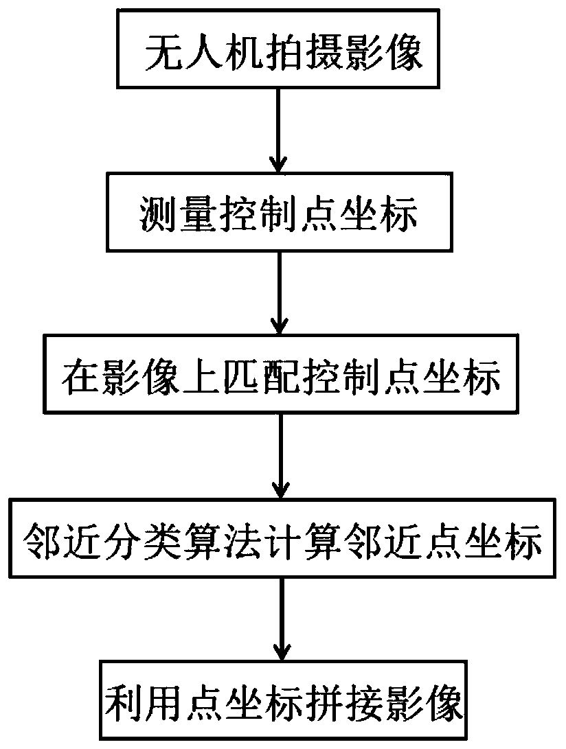
[0041] Below in conjunction with accompanying drawing, technical scheme of the present invention will be further described:

[0042] The present invention proposes a fully automatic orthophoto stitching method based on GPS ground control points, such as figure 1 As shown, it specifically includes the following steps:

[0043] S1. Utilize the UAV to shoot the survey area, and obtain a set of ground remote sensing images with a certain degree of overlap, and there are ground control points with eye-catching signs in the images. During the aerial photography of drones, the flight route planning is set according to the east-west direction, the route interval and side overlap during shooting are between 30% and 40%, and the course overlap is between 65% and 75%.

[0044] In the area to be studied, select some natural features with obvious characteristics and easy to receive GPS satellite signals as ground control points for drones to shoot images, such as the roof of a high-rise b...


PUM


Abstract

The invention provides a full-automatic orthographic image splicing method based on a GPS ground control point, and the method comprises the following steps: S1, employing an unmanned aerial vehicle to shoot a group of images with a certain overlapping degree, and enabling the images to comprise eye-catching ground control points; S2, measuring coordinates of a ground control point by adopting a GPS RTK method, and sending the coordinates of the control point to the unmanned aerial vehicle through radio frequency equipment; S3, the unmanned aerial vehicle automatically matches the control point coordinates to an image shot by the unmanned aerial vehicle according to the control point coding information; S4, calculating coordinates of adjacent ground object points in the image by using thecontrol point coordinates and an adjacent classification algorithm; S5, repeating S4 operation to process all images; And S6, automatically splicing the images by using the marked coordinates in the processed images. According to the method, manual operation is avoided, the image splicing time is shortened, the automation degree is high, and the splicing precision is good.

Description

technical field [0001] The invention relates to a fully automatic orthophoto stitching method, which belongs to the technical field of remote sensing image processing. Background technique [0002] With the development of social economy and the needs of national defense construction, the demand for high-resolution remote sensing images and basic geographic information in various industries in society is becoming more and more urgent, and the requirements for their current situation are getting higher and higher. The remote sensing data obtained by satellites and manned aviation aircraft alone cannot fully meet the needs of image data acquisition and processing. Compared with traditional aerospace remote sensing technology, UAV remote sensing technology, as an emerging low-altitude remote sensing technology, has strong flexibility, With many advantages such as convenient operation, good current situation, high resolution and low investment, it has become one of the indispensa...

Claims


Application Information

Patent Timeline
Patent Type & Authority Applications(China)
IPC IPC(8): G06T3/40G06K9/00G06K9/62
CPCY02T10/40
Inventor 王庆李静佳吴向阳
Owner SOUTHEAST UNIV
Why Eureka
Try Eureka