A three-dimensional live-action modeling method for hydrological monitoring

A technology of real scene modeling and hydrological monitoring, applied in 3D modeling, image data processing, instruments, etc., can solve problems such as difficulty in understanding, achieve the effect of enhancing geographic accuracy and ensuring reliability

Pending Publication Date: 2019-05-28
江苏嘉禾环境科技有限公司
View PDF2 Cites 6 Cited by
  • Summary
  • Abstract
  • Description
  • Claims
  • Application Information

AI Technical Summary

Problems solved by technology

[0002] At present, in the field of water regime monitoring, the results of water regime monitoring are mostly presented in specialized forms such as data and charts, which are difficult for non-professionals to understand

Method used


Image

  • A three-dimensional live-action modeling method for hydrological monitoring
  • A three-dimensional live-action modeling method for hydrological monitoring

Examples


Embodiment Construction

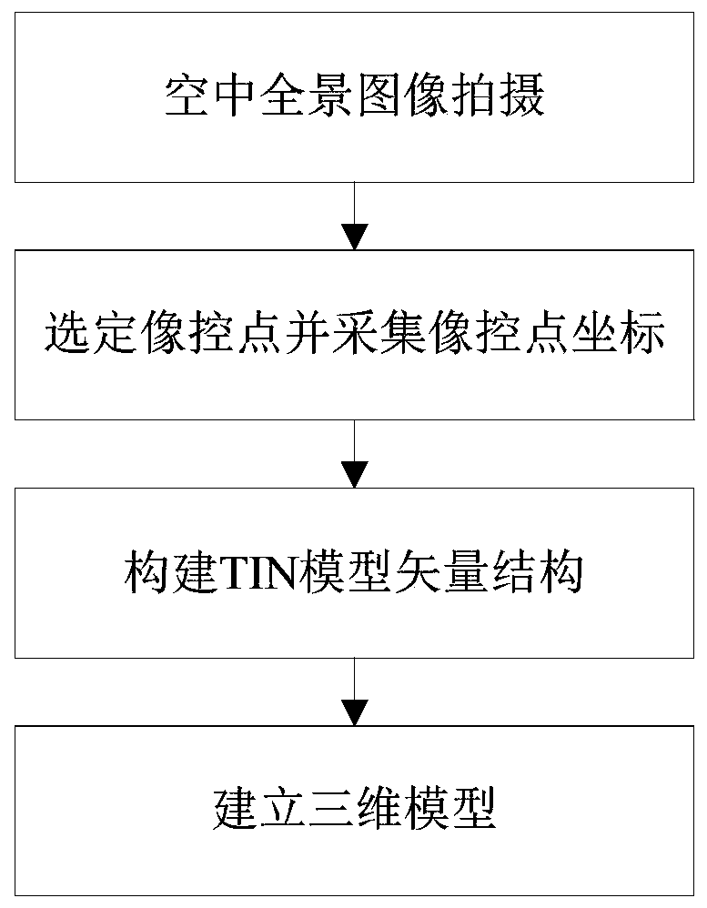
[0020] like figure 1 As shown, a kind of three-dimensional real scene modeling method for hydrological monitoring provided by the present invention comprises the following steps:

[0021] Step 1. Taking the hydrological station as the center to take aerial panoramic images of the hydrological station and its surrounding environment in the air. The photos taken should have moderate contrast, moderate contrast, harmonious light and shade, clear imaging, consistent color tone, and good image quality. The collection range is based on Geographical information determination of the hydrological station and its surroundings;

[0022] Step 2, select the image control point and collect the coordinates of the image control point. The image control point includes landmark points and feature points. Control point coordinates for accuracy evaluation;

[0023] Step 3: Puncture the image control points, and use the high-density point cloud obtained by dense matching of multi-view images to ...


PUM


Abstract

The invention provides a three-dimensional live-action modeling method for hydrological monitoring. The method comprises the following steps of: carrying out aerial panoramic image shooting on the hydrological station and the surrounding environment thereof in the air by taking the hydrological station as a center; selecting a photo control point, collecting photo control point coordinates, carrying out precision evaluation on the collected photo control point coordinates, carrying out point pricking on the photo control point, constructing a three-dimensional TIN model under different levelsof detail degrees, and carrying out texture mapping by utilizing the aerial panoramic image to realize three-dimensional model establishment. According to the three-dimensional live-action modeling method, live-action modeling of the three-dimensional model is carried out with the hydrological station as the center and the surrounding environment, the hydrological monitoring model can be established in a targeted mode, the three-dimensional model can be conveniently combined with hydrological monitoring data, and a vivid decision basis can be provided for hydrological early warning decision making due to hydrological simulation; The geographic accuracy of three-dimensional model modeling can be enhanced and the reliability of hydrological simulation can be ensured by utilizing the layout of the image control points and the feature points and the accuracy evaluation of the image control point coordinates.

Description

technical field [0001] The invention relates to a three-dimensional real scene modeling method, in particular to a three-dimensional real scene modeling method for hydrological monitoring. Background technique [0002] At present, in the field of water regime monitoring, the results of water regime monitoring are mostly presented in specialized forms such as data and charts, which are difficult for non-professionals to understand. Therefore, it is necessary to design a 3D real scene modeling method for hydrological monitoring, which can reduce the difficulty of non-professionals in understanding monitoring data. Contents of the invention [0003] The purpose of the present invention is to provide a three-dimensional real scene modeling method for hydrological monitoring, which can reduce the difficulty of non-professionals in understanding monitoring data. [0004] In order to achieve the above-mentioned purpose of the invention, the present invention provides a three-dim...

Claims


Application Information

Patent Timeline
Patent Type & Authority Applications(China)
IPC IPC(8): G06T17/20G06T19/20G06T7/33G06T3/40
Inventor 聂银波闫冬刘昊霖
Owner 江苏嘉禾环境科技有限公司
Why Eureka
Try Eureka