Residual correction method for NWP inversion tropospheric delay under multi-factor constraints
A tropospheric delay and multi-factor technology, applied in satellite radio beacon positioning systems, measuring devices, instruments, etc., can solve problems such as poor tropospheric delay accuracy, achieve the effects of improving positioning accuracy, shortening convergence time, and wide application range
- Summary
- Abstract
- Description
- Claims
- Application Information
AI Technical Summary
Problems solved by technology
Method used
Image
Examples
Embodiment 1
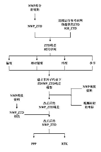
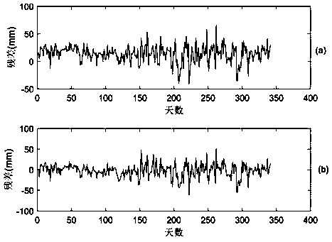
[0037] The first step is to obtain the ZTD of SCIP station and ROCK station in 2015 from the IGS MGEX network, record it as IGS_ZTD, and eliminate gross errors.
[0038] In the second step, in the ERA-Interim (Jan1979-present) product of the reanalysis data of the European Center for Mesoscale Weather Forecasting (ECMWF), obtain a plane resolution of 0.125°×0.125°, a vertical resolution of 37 layers, and a time resolution of It is the 6-hour layered meteorological data of SCIP station and ROCK station area in 2015. The meteorological data includes air pressure, temperature, relative humidity and geopotential height.
[0039] The third step is to use the integration method to invert the regional meteorological data of the SCIP station to obtain the ZTD of the SCIP station in 2015, which is recorded as NWP_ZTD. The calculation formula of ZTD inversion by layered integration method is:
[0040]
[0041] where ZTD grid is the ZTD value of the grid point at the height of the m...
Embodiment 2
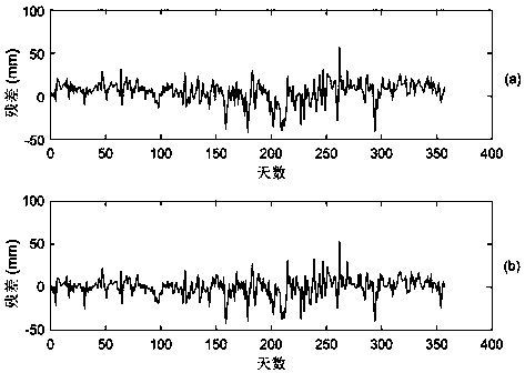
[0055] The first step is to obtain the ZTD of PIN1 station and ROCK station for consecutive years in 2015 from the IGS MGEX network, record it as IGS_ZTD, and eliminate gross errors.
[0056] In the second step, in the ERA-Interim (Jan1979-present) product of the reanalysis data of the European Center for Mesoscale Weather Forecasting (ECMWF), obtain a plane resolution of 0.125°×0.125°, a vertical resolution of 37 layers, and a time resolution of It is the 6-hour layered meteorological data of PIN1 station and ROCK station area in 2015. The meteorological data includes air pressure, temperature, relative humidity and geopotential height.
[0057] The third step is to use the integration method to invert the regional meteorological data of the PIN1 station to obtain the ZTD of the SCIP station in 2015, which is recorded as NWP_ZTD. The calculation formula of ZTD inversion by layered integration method is:
[0058]
[0059] In the above formula: ZTD grid is the ZTD value of...
PUM
 Abstract
Description
Claims
Application Information
 - R&D
- Intellectual Property
- Life Sciences
- Materials
- Tech Scout
- Unparalleled Data Quality
- Higher Quality Content
- 60% Fewer Hallucinations
Browse by: Latest US Patents, China's latest patents, Technical Efficacy Thesaurus, Application Domain, Technology Topic, Popular Technical Reports.
© 2025 PatSnap. All rights reserved.Legal|Privacy policy|Modern Slavery Act Transparency Statement|Sitemap|About US| Contact US: help@patsnap.com


