Coordinated local path planning method based on V2X communication and binocular vision

A technology of local path planning and binocular vision, which is applied in services based on location information, services based on specific environments, communications between vehicles and infrastructure, etc. information and environmental perception information, and other issues such as low reliability, to achieve the effect of improving reliability, reducing computing load, and expanding the range of perception

Active Publication Date: 2019-06-21
CHONGQING UNIV OF POSTS & TELECOMM
View PDF9 Cites 52 Cited by
  • Summary
  • Abstract
  • Description
  • Claims
  • Application Information

AI Technical Summary

Problems solved by technology

[0004] The invention aims at the problems that a single vehicle has a small range of environmental perception, low rel

Method used


Image

  • Coordinated local path planning method based on V2X communication and binocular vision
  • Coordinated local path planning method based on V2X communication and binocular vision
  • Coordinated local path planning method based on V2X communication and binocular vision

Examples


Embodiment Construction

[0044] The technical solutions in the embodiments of the present invention will be described clearly and in detail below with reference to the drawings in the embodiments of the present invention. The described embodiments are only some of the embodiments of the invention.

[0045] The technical scheme that the present invention solves the problems of the technologies described above is:

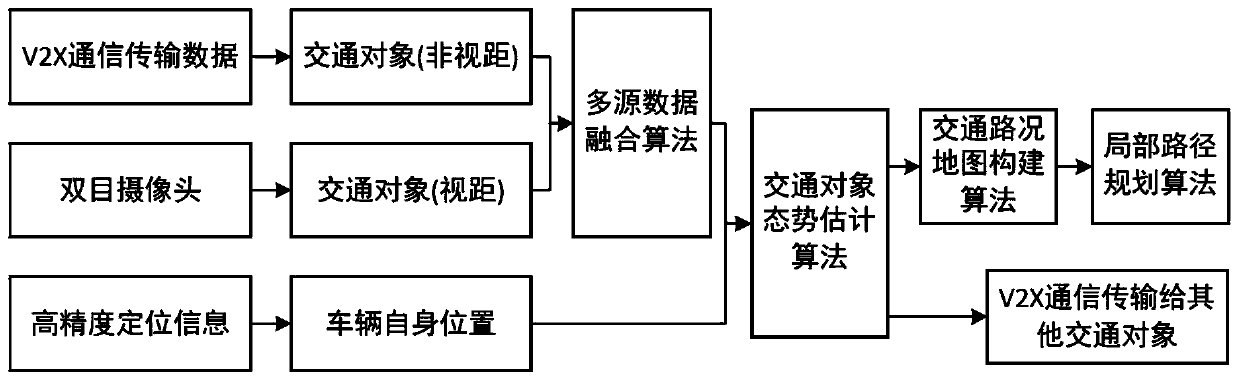
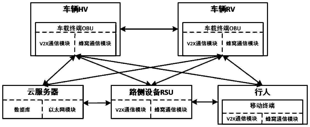
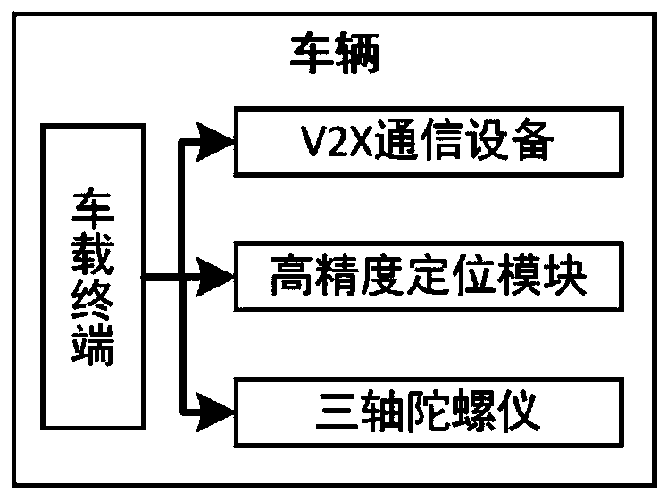
[0046] A collaborative local path planning method based on V2X communication and binocular vision, such as figure 1 Shown is the overall architecture diagram of the method, which is mainly controlled by the vehicle-mounted terminal (OBU), roadside unit (RSU), cloud server, mobile terminal, OBD device, vehicle central control device, binocular camera, and cooperative local path planning device complete, figure 2 Shown is the framework diagram of V2X communication. Among them, the OBU device on the host vehicle HV (Host Vehicle) is the information collection center for local path planning,...


PUM


Abstract

The invention claims for protection of a coordinated local path planning method based on V2X communication and binocular vision. An OBU acquires vehicle body information and environmental informationthrough a binocular preposed camera, OBD equipment and V2X communication and the information is transmitted to a coordinated local path planning controller; with a traffic object mixed state estimation model, state prediction is carried out on a traffic object state, spatio-temporal data fusion is carried out on the traffic object information and traffic rules after state estimation based on a multi-source data fusion algorithm, a traffic road map with high credibility is constructed by the fused traffic data according to a coordinate mapping model, an own vehicle state is calculated by combining own vehicle information according to an own vehicle state estimation model, and then an optimal smooth driving path of the current vehicle is calculated based on an improved local path planning algorithm; and then the path is transmitted to the OBU and the information is broadcasted to other vehicles through V2X. According to the invention, the accuracy of vehicle environment perception and local path planning is improved by combining visibility-range and non-visibility-range traffic object sense sensing.

Description

technical field [0001] The invention belongs to the field of intelligent networked vehicles and intelligent transportation, and relates to a local path planning method based on V2X communication and binocular vision. Background technique [0002] With the rapid increase of the number of vehicles in our country, the number of traffic accidents is also increasing, most of which are caused by improper operation of drivers. In an emergency, the driver needs a certain amount of time to react, and it is difficult to make an optimal decision, which are potential factors leading to traffic accidents. Therefore, reducing the influence of human factors on traffic accidents is now becoming more and more concerned. Before an accident occurs, the vehicle can automatically take corresponding measures to avoid traffic accidents. This vehicle active safety technology is of great significance for preventing traffic accidents. Partial path planning is one of the key technologies for vehicle...

Claims


Application Information

Patent Timeline
IPC IPC(8): G08G1/01G08G1/0968H04L29/08H04W4/02H04W4/024H04W4/44G06K9/00G01C21/20G01C21/34G05D1/02
Inventor 蒋建春张卓鹏曾素华奚川龙王肖贾敬森郭真妮彭飞
Owner CHONGQING UNIV OF POSTS & TELECOMM
Why Eureka
Try Eureka