

Mobile terminal high-precision oblique photography three-dimensional modeling method based on OpenGL
A technology of oblique photography and 3D modeling, which is used in 3D modeling, image enhancement, instruments, etc. It can solve the problem that high-precision oblique photography models cannot be loaded on a large scale, eliminate the influence of aircraft attitude and terrain fluctuations, and improve accuracy. , the effect of model accuracy improvement
- Summary
- Abstract
- Description
- Claims
- Application Information
AI Technical Summary
Problems solved by technology
Method used
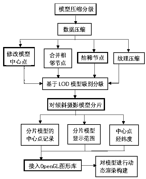
Image

Examples
Embodiment 1
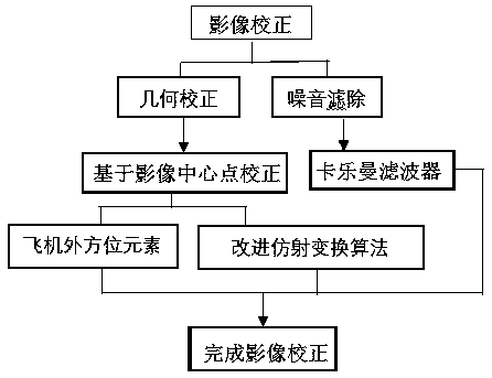
[0052] Example 1, see figure 1 , 2 , 3, 4; the image is corrected for the center image point, and the filter removes the noise step, see the image correction method in the present invention figure 1 :
[0053] First, the area to be measured is acquired by drones with 60% overlap rate image data, and the drones are equipped with five-lens cameras. Due to the influence of aircraft attitude, terrain fluctuations, and noise, the acquired image data needs to be corrected and imaged. Transformation; each piece of image data obtained at this time has the coordinates of the center point, recording the longitude and latitude of the drone when shooting the area;
[0054] Use the outer orientation elements of each image data combined with the affine transformation formula to calculate the offset of the center point of the image, and calculate the correct center point based on the offset of the center point; improve the accuracy of the oblique photographic model, and the accuracy of the...
PUM
 Abstract
Description
Claims
Application Information