Optimal coverage satellite image screening method based on geographic grids
A satellite image and geographic grid technology, applied in the field of remote sensing, can solve the problems of satellite image automation level and low efficiency, and achieve the effect of ensuring reliability, good versatility, and small amount of calculation
- Summary
- Abstract
- Description
- Claims
- Application Information
AI Technical Summary
Problems solved by technology
Method used
Image
Examples
Embodiment Construction
[0029] The technical scheme of the invention will be described in detail below in conjunction with the accompanying drawings and embodiments.
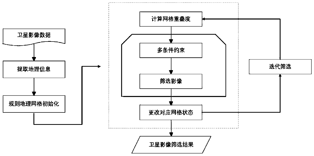
[0030] The present invention proposes a method based on regular geographic grids, using iteration and multi-condition constraints (constraint conditions allow self-definition, strong scalability), and screens large-scale satellite images that cover the same area multiple times, effectively screening It produces large-scale multi-source satellite images covering a single time. At the same time, this screening algorithm is fully automatic, with a very small amount of calculation and high processing efficiency. It is suitable for satellite images of various sensor types.
[0031] Such as figure 1 , the embodiment provides a geographic grid-based optimal coverage satellite image screening method, based on a regular geographic grid, using loop iterations and multi-conditional constraints (conditions are self-defined, expandable), for large-...
PUM
 Abstract
Description
Claims
Application Information
 - R&D
- Intellectual Property
- Life Sciences
- Materials
- Tech Scout
- Unparalleled Data Quality
- Higher Quality Content
- 60% Fewer Hallucinations
Browse by: Latest US Patents, China's latest patents, Technical Efficacy Thesaurus, Application Domain, Technology Topic, Popular Technical Reports.
© 2025 PatSnap. All rights reserved.Legal|Privacy policy|Modern Slavery Act Transparency Statement|Sitemap|About US| Contact US: help@patsnap.com


