Regional scale wheat stripe rust monitoring method based on remote sensing image red wave band

A technology for wheat stripe rust and remote sensing imagery, applied in neural learning methods, image enhancement, image analysis and other directions, can solve problems such as poor accuracy

Active Publication Date: 2019-07-12
ANHUI UNIVERSITY
View PDF6 Cites 12 Cited by
  • Summary
  • Abstract
  • Description
  • Claims
  • Application Information

AI Technical Summary

Problems solved by technology

[0008] The purpose of the present invention is to solve the defect of poor accuracy of remote sensing monitoring of wheat stripe rust in the prior art, and provide a regional-scale monitoring method of wheat stripe rust based on the red edge band of remote sensing images to solve the above problems

Method used


Image

  • Regional scale wheat stripe rust monitoring method based on remote sensing image red wave band
  • Regional scale wheat stripe rust monitoring method based on remote sensing image red wave band
  • Regional scale wheat stripe rust monitoring method based on remote sensing image red wave band

Examples


Embodiment Construction

[0067] In order to have a further understanding and understanding of the structural features of the present invention and the achieved effects, the preferred embodiments and accompanying drawings are used for a detailed description, as follows:

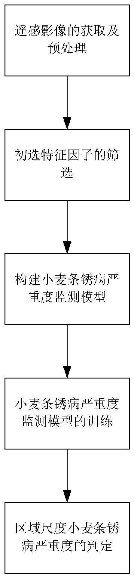
[0068] Such as figure 1 As shown, the regional scale wheat stripe rust monitoring method based on the red edge band of the remote sensing image of the present invention comprises the following steps:

[0069] The first step is the acquisition and preprocessing of remote sensing images.

[0070] In the present invention, the data used mainly include remote sensing data and wheat stripe rust field survey data (label data). The remote sensing data is Sentinel-2 satellite remote sensing data. Its detailed band and resolution information are shown in Table 1. According to the weather conditions in the study area, the image data with better quality and the time closest to the ground survey were selected. A 1m×1m quadrat was taken for ea...


PUM


Abstract

The invention relates to a regional scale wheat stripe rust monitoring method based on a remote sensing image red-side waveband. Compared with the prior art, the regional scale wheat stripe rust monitoring method solves the defect of poor wheat stripe rust remote sensing monitoring precision. The method comprises the following steps: acquiring and preprocessing a remote sensing image; screening primarily selected characteristic factors; constructing a wheat stripe rust severity monitoring model; training a wheat stripe rust severity monitoring model; and judging the severity of the regional scale wheat stripe rust. According to the invention, Sentine-2 is used tocarry out inversion on the remote sensing image to obtain a broadband vegetation index feature and a red-edge vegetation index feature related to the disease, and the Relief FF and K-means algorithm to screen a broadband vegetation index feature set which is relatively high in disease correlation and relatively low in redundancy and a feature set with added red-edge vegetation indexes, and a wheat stripe rust severity monitoring model is established with a BPNN algorithm, so as to realize monitoring of the wheat stripe rustseverity on a regional scale.

Description

technical field [0001] The invention relates to the technical field of remote sensing data processing, in particular to a regional-scale monitoring method for wheat stripe rust based on the red edge band of remote sensing images. Background technique [0002] Wheat stripe rust (Puccinia striiformis f. sptritici) is an airborne disease, spores are transmitted through the air, and has the characteristics of wide incidence, strong prevalence, and high incidence probability. It is one of the main diseases that threaten wheat yield. After the wheat is damaged, it can lead to early withering of the leaves and a reduction in the number of ears. Generally, the yield can be reduced by 5% to 10%, and the severe disease field can reduce the yield by more than 20%. Traditional pest monitoring mainly relies on ground surveys. Although it is highly authentic, it is time-consuming and laborious and difficult to meet the needs of large-scale monitoring. Remote sensing technology is a new t...

Claims


Application Information

Patent Timeline
Patent Type & Authority Applications(China)
IPC IPC(8): G06K9/00G06K9/62G06N3/04G06N3/08G06T7/00G06T7/136
CPCG06N3/084G06T7/0002G06T7/136G06T2207/10032G06T2207/10048G06T2207/20081G06T2207/30188G06V20/188G06N3/044G06F18/23213G06F18/241
Inventor 黄林生江静黄文江梁栋徐超张东彦赵晋陵张寒苏胡廷广
Owner ANHUI UNIVERSITY
Why Eureka
Try Eureka