
Multi-platform point cloud intelligent processing method for holographic mapping

An intelligent processing and multi-platform technology, applied in image data processing, details related to processing steps, 3D image processing, etc., can solve the problem that two-dimensional spatial data expression cannot meet the needs of cognition, and improve the product update cycle , easy to achieve, and improve work productivity

Active Publication Date: 2019-07-16
WUHAN UNIV +1
View PDF9 Cites 13 Cited by
  • Summary
  • Abstract
  • Description
  • Claims
  • Application Information

AI Technical Summary

Problems solved by technology

The expression of two-dimensional spatial data represented by maps and images is far from meeting people's needs for real three-dimensional space cognition. How to accurately and quickly obtain three-dimensional geographic information has become the fundamental task and urgent demand in the field of surveying and mapping geographic information.

Method used


Image

  • Multi-platform point cloud intelligent processing method for holographic mapping
  • Multi-platform point cloud intelligent processing method for holographic mapping
  • Multi-platform point cloud intelligent processing method for holographic mapping

Examples


Embodiment Construction

[0042] The technical solutions of the present invention will be described in detail below in conjunction with embodiments and drawings.

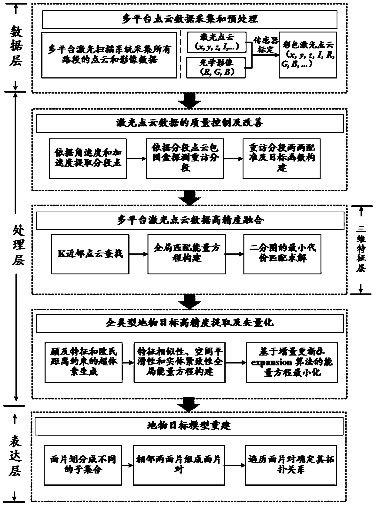
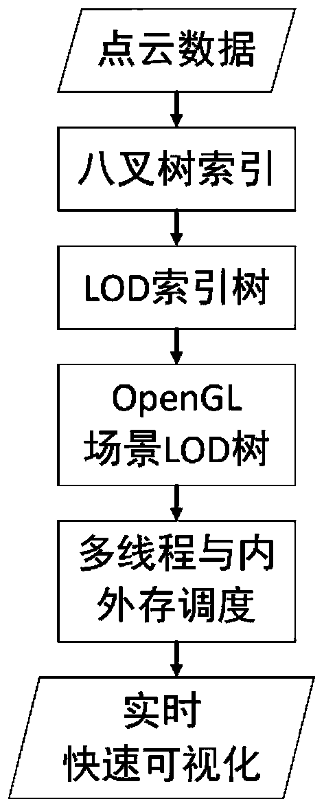
[0043] The present invention proposes a new multi-platform point cloud intelligent processing method for holographic surveying and mapping, which uses airborne, vehicle-mounted, ground-mounted and portable (backpack) multi-platform point clouds and images as data sources to achieve full element extraction of urban scenes And the automatic reconstruction of the real scene model is developed as the goal. The method includes 5 key parts: organization and scheduling of massive point cloud data, point cloud data quality control and improvement, multi-platform laser point cloud data high-precision fusion, automatic extraction of ground objects, and ground object model reconstruction, etc. The degree of automation of point cloud data processing is improved, the production efficiency is improved, and the method is simple and easy to implement. The over...


PUM


Abstract

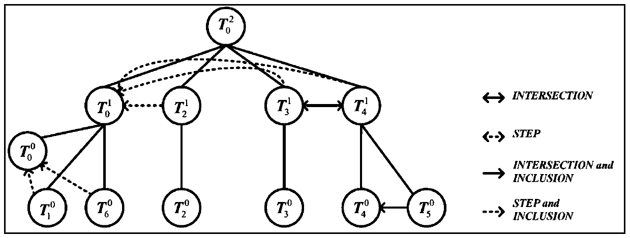
The invention relates to a multi-platform point cloud intelligent processing method for holographic mapping. The method comprises the steps of organizing and scheduling mass point cloud data; carryingout point cloud data quality control and improvement, and achieving automatic correction of point cloud position consistency under the condition of no control point; carrying out high-precision fusion of multi-platform laser point cloud data, which comprises neighbor point cloud search, global matching energy equation construction and bipartite graph minimum cost matching; automatically extracting the ground object targets, namely realizing high-precision extraction and vectorization of the full-type ground object targets through geometric semantic consistency extraction of the ground objecttargets; carrying out the ground object target multi-detail-level model reconstruction based on the Grignard law, which comprises the step of establishing a multi-detail-level three-dimensional modelof the ground object target through a Grignard mathematical model and a topological relation graph. The holographic surveying and mapping product production process based on the multi-platform point cloud data is achieved, the method is easy to operate and implement, the manual workload of data processing can be greatly reduced, the working production efficiency is improved, and the product updating period is prolonged.

Description

Technical field [0001] The invention relates to the key technologies of intelligent holographic surveying and mapping, including processing of multi-platform laser point cloud data organization and management, quality improvement, benchmark unification, automatic extraction of ground objects and reconstruction of real scene models, and belongs to the field of automatic laser point cloud processing and new basic surveying and mapping. . Background technique [0002] With the penetration of the "digital earth" and the rapid development of "smart cities", people's demand for comprehensive, accurate, and real-time geographic information data, especially high-precision three-dimensional geographic information, is growing. The expression of two-dimensional spatial data represented by maps and images is far from meeting people's needs for real three-dimensional spatial cognition. How to accurately and quickly obtain three-dimensional geographic information has become a fundamental task ...

Claims


Application Information

Patent Timeline
Patent Type & Authority Applications(China)
IPC IPC(8): G06T19/00G06T15/00
CPCG06T15/00G06T19/006G06T2200/08
Inventor 杨必胜顾建祥董震杨铭邹响红
Owner WUHAN UNIV
Learn More