A satellite navigation ground simulation device and method

A ground simulation and satellite navigation technology, which is applied in the field of satellite navigation ground simulation, can solve the problems of damage to precision components of positioning base stations, inconvenient position adjustment, waste of manpower and time, etc., to achieve accurate accuracy, save manpower and time, The effect of eliminating potential safety hazards

Active Publication Date: 2022-03-01
郑州航空港经济综合实验区空港人工智能研究院 +1
View PDF20 Cites 0 Cited by
  • Summary
  • Abstract
  • Description
  • Claims
  • Application Information

AI Technical Summary

Problems solved by technology

[0005] However, the above-mentioned positioning base station is fixed on the wall or ceiling, which is inconvenient to adjust the position, and before and after the simulation, the simulation operator needs to manually install and disassemble the operation, which wastes manpower and time. There will be certain safety hazards in working at heights, and it is very easy to cause damage to the precision components on the positioning base station during the installation and disassembly process

Method used


Image

  • A satellite navigation ground simulation device and method
  • A satellite navigation ground simulation device and method
  • A satellite navigation ground simulation device and method

Examples


Embodiment 1

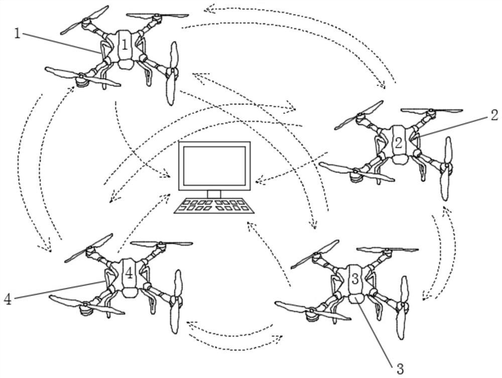
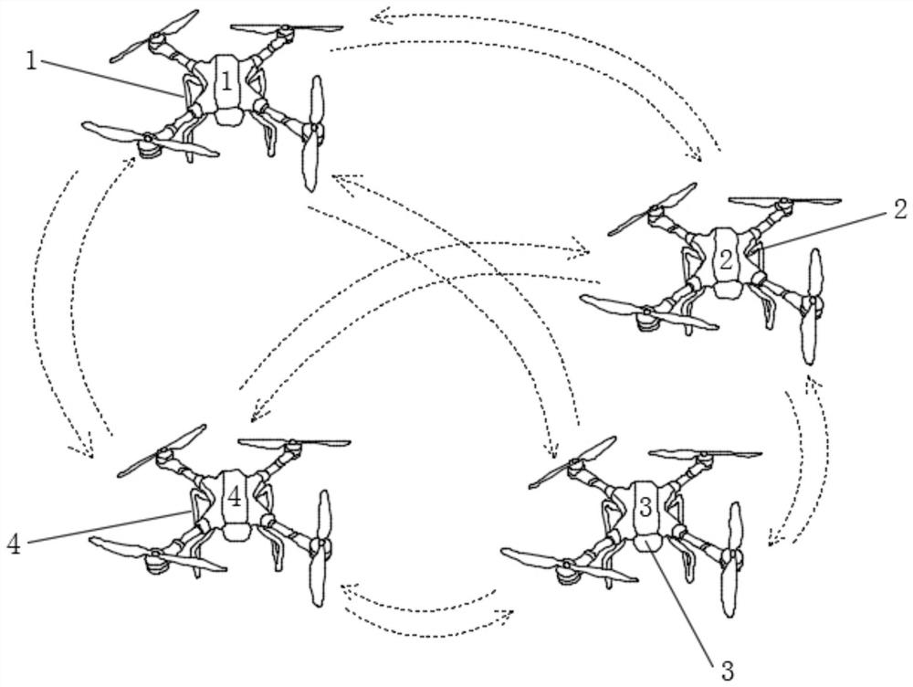
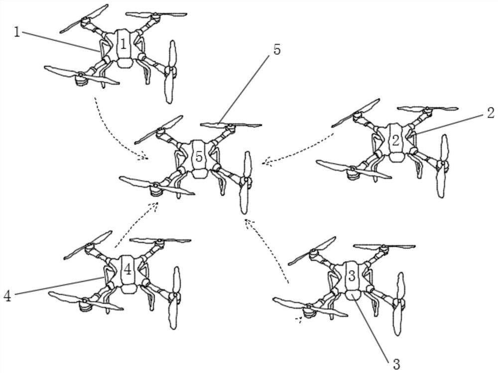
[0040] see figure 1 , a satellite navigation ground simulation device and method, including a positioning base station group, a tracked part and a receiving control module, the positioning base station group is installed in a simulated unmanned aerial vehicle group, and the simulated unmanned aerial vehicle group conducts regular operations on a preset orbit The movement is to simulate the operation of the satellite, and the tracked part also moves regularly on the preset orbit, please refer to image 3 , the positioning base station group locates the tracked part and sends a position signal to it, and the receiving control module receives the position signal sent by the positioning base station group, and obtains the precise position through calculation. In this scheme, the positioning base station group is installed in the simulated UAV group , use the simulated UAV group to move regularly on the preset orbit to simulate the satellite operation, directly control and change t...


PUM


Abstract

The invention discloses a satellite navigation ground simulation device and method, which belong to the technical field of satellite navigation ground simulation. A satellite navigation ground simulation device and method include a positioning base station group, a tracked part and a receiving control module. The positioning base station group is installed on In the simulated unmanned aerial vehicle group, the positioning base station group locates the tracked part and sends a position signal to it, and the receiving control module receives the position signal sent by the positioning base station group, and obtains the precise position through calculation. In this scheme, the positioning base station group is installed on In the simulated UAV group, the simulated UAV group is used to move regularly on the preset orbit to simulate the operation of the satellite, and the position of the positioning base station is directly controlled from the receiving control module to realize installation-free and disassembly-free, saving Save manpower and time, eliminate potential safety hazards in installation and disassembly operations, and realize the simulation of satellite navigation systems safely and conveniently.

Description

technical field [0001] The invention relates to the technical field of satellite navigation ground simulation, and more specifically, to a satellite navigation ground simulation device and method. Background technique [0002] Positioning and navigation technology is a multi-disciplinary high-tech involving automatic control, computer, microelectronics, optics, mechanics, and mathematics. It is the key technology to realize the flight mission of aircraft, especially spacecraft, and the core technology of weapon precision guidance. Improving the maneuverability, response rate and long-range precision strike capability of aircraft, spacecraft and weaponry is of great significance, and is widely used in modern and weapon platforms such as sea, land and air. [0003] The Beidou satellite positioning system is a kind of global satellite positioning system. Its basic working principle is to measure the distance between the satellite with known position and the user receiver, and t...

Claims


Application Information

Patent Timeline
Patent Type & Authority Patents(China)
IPC IPC(8): G09B25/00
CPCG09B25/00
Inventor 高健
Owner 郑州航空港经济综合实验区空港人工智能研究院
Why Eureka
Try Eureka