Geomagnetic matching navigation method based on magnetic declination correction

A geomagnetic matching and navigation method technology, applied in ground navigation and other directions, can solve problems such as complex mathematical modeling of geomagnetic database, cumulative error of inertial devices, and uncorrectable movement direction deviation, and achieve the effect of reducing computational complexity and improving accuracy

Active Publication Date: 2019-07-26
HANGZHOU DIANZI UNIV
View PDF4 Cites 10 Cited by
  • Summary
  • Abstract
  • Description
  • Claims
  • Application Information

AI Technical Summary

Problems solved by technology

However, the mathematical modeling of the geomagnetic database is complex, and it is required that the geomagnetic information and the mileage information should be strictly corresponding when the data is col

Method used


Image

  • Geomagnetic matching navigation method based on magnetic declination correction
  • Geomagnetic matching navigation method based on magnetic declination correction
  • Geomagnetic matching navigation method based on magnetic declination correction

Examples


Embodiment example 2

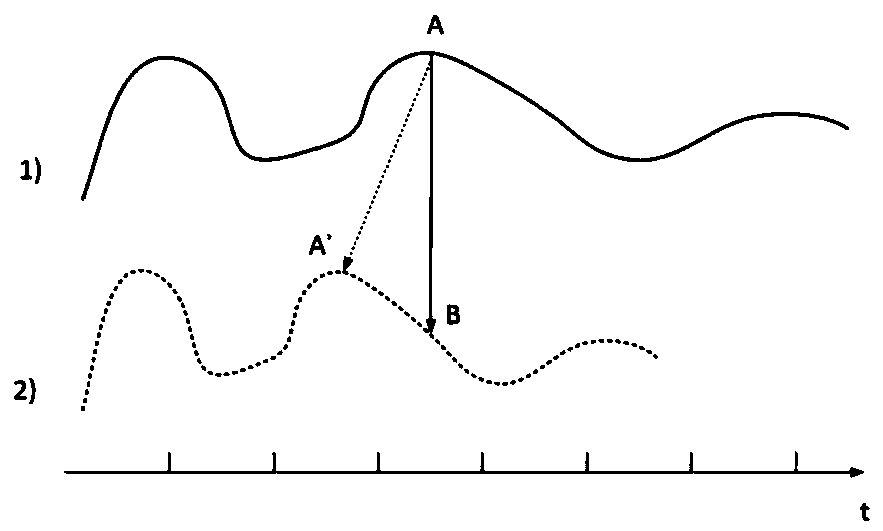
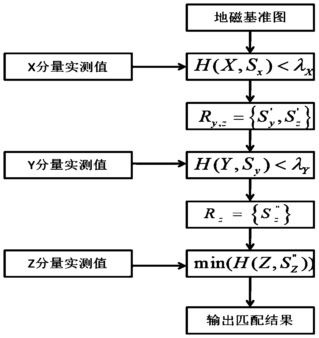
[0108] combine figure 2 , image 3 , Figure 4 To illustrate the present invention, Figure 5 It is a geomagnetic matching navigation method based on magnetic declination correction. After actual measurement, and finally through simulation software simulation, it is based on the motion track diagram drawn by the two-dimensional plan of the underground garage. In the experiment, when the discrete geomagnetic database and the magnetic declination error database were established, the grid sampling interval was 1 meter, and 50 data were collected at one sampling point, and the gross error was removed by the Raida criterion. Take the average and save the data in the database. Then, by moving for a certain distance, geomagnetic matching positioning is performed to obtain the initial positioning point. Then correct the dead reckoning positioning track for the following movement track through the magnetic declination error compensation, do geomagnetic matching positioning settlem...


PUM


Abstract

The invention discloses a geomagnetic matching navigation method based on magnetic declination correction. The geomagnetic matching navigation method comprises the steps that geomagnetic triaxial vector magnetic field intensity data is first collected, and a grid type geomagnetic database is established; an electronic compass is utilized to sample magnetic declination, and a grid type magnetic declination error database is established; then through a method of generalized continuation approximation, database files with grids subdivided as much as possible are generated for the collected discrete data; in the online navigation and positioning stage, a series of geomagnetic field intensity information sequences are measured by a geomagnetic sensor, at the same time, accelerated speeds and direction angles obtained by an inertial device are subjected to dead reckoning to calculate a motion trajectory, and the motion trajectory is integrated with the geomagnetic field intensity informationsequences; the direction of the motion trajectory is corrected through error compensation; and a corrected dead reckoning positioning result and a corrected geomagnetic feature matching positioning result are subjected to extended Kalman filter fusion to obtain a final positioning result. The geomagnetic matching navigation method improves the accuracy of dead reckoning and reduces the computational complexity.

Description

technical field [0001] The invention belongs to the field of geomagnetic navigation and relates to a geomagnetic feature similarity matching navigation method based on magnetic declination correction. [0002] technical background [0003] With the continuous development of the Internet of Things and the popularity of smart terminals in the 21st century, users' demand for location-based services (LBS) continues to increase. Users urgently need to obtain location information services with high positioning accuracy in various geographical locations. Currently, there are various navigation methods available. Satellite navigation system is one of the most popular and very important methods, such as Beidou navigation system , GPS navigation system, GLONASS navigation system and other satellite navigation systems can provide high-precision location information for navigation and positioning service users around the clock. Due to the global popularity of smart phones and the Interne...

Claims


Application Information

Patent Timeline
IPC IPC(8): G01C21/08
CPCG01C21/08
Inventor 保金宏尚俊娜施浒立
Owner HANGZHOU DIANZI UNIV
Why Eureka
Try Eureka