Drainage basin rainfall product correction method and system based on satellite-ground fusion

A watershed and product technology, applied in the field of watershed rainfall product correction based on satellite-ground fusion, can solve problems such as poor rainfall monitoring accuracy, and achieve the effects of reducing rainfall deviation, reducing pixel value smoothing, and improving estimation accuracy.

Active Publication Date: 2019-07-26
WUHAN UNIV
View PDF3 Cites 10 Cited by
  • Summary
  • Abstract
  • Description
  • Claims
  • Application Information

AI Technical Summary

Problems solved by technology

[0030] Aiming at the problem that the above-mentioned high-spatial resolution multi-source fusion rainfall products are sparsely distributed on the ground and the terrain is complex in mountainous areas, the daily rainfall monitoring accuracy is poor, the present invention proposes a watershed rainfall product correction method based on satellite-ground fusion (WHU-SGCC, Wuhan Univer

Method used


Image

  • Drainage basin rainfall product correction method and system based on satellite-ground fusion
  • Drainage basin rainfall product correction method and system based on satellite-ground fusion
  • Drainage basin rainfall product correction method and system based on satellite-ground fusion

Examples


Embodiment Construction

[0078] Below in conjunction with accompanying drawing and embodiment the technical scheme of the present invention will be further described:

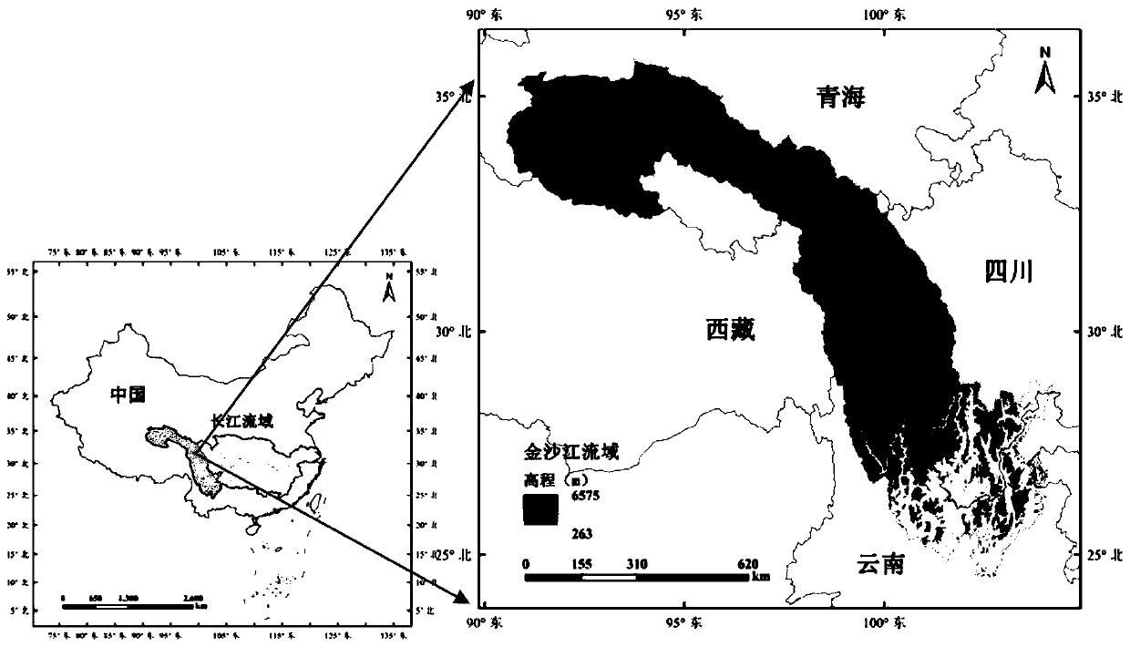
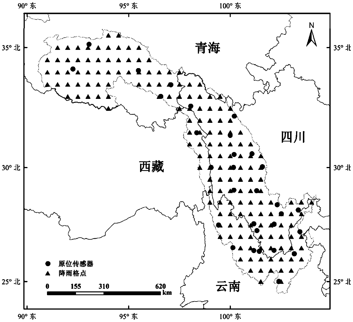
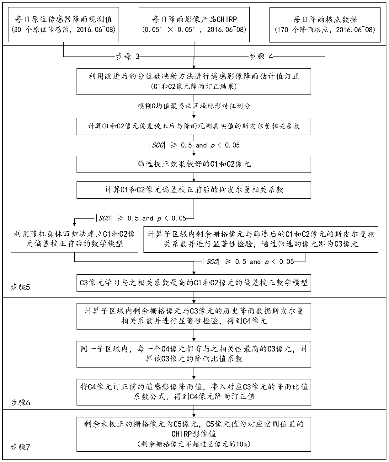
[0079] Embodiment First select the Jinsha River Basin in the upper reaches of the Yangtze River as the research area, the latitude and longitude of the lower left corner of the region is (26.0394062025, 119.2702907161), and the latitude and longitude of the upper right corner is (26.1295047540, 119.3653516906), as figure 1 shown. The input data include daily in-situ sensor rainfall observations, daily rainfall grid point data (spatial resolution 0.5°×0.5°), and daily rainfall image products (that is, rainfall estimates from remote sensing images). The first two are the actual rainfall values, which can be downloaded from the National Meteorological Information Center. The rainfall estimation value of remote sensing images is selected from the CHIRP (the Climate Hazards Group Infrared Precipitation) rainfall dataset with a spatial reso...


PUM


Abstract

The invention provides a drainage basin rainfall product correction method and system based on satellite-ground fusion, and the method comprises the steps: dividing all pixels in a remote sensing image to be corrected into five types, and enabling a C1 pixel to be an image grid pixel corresponding to the position of a ground in-situ sensor; wherein the C2 pixel is an image grid pixel correspondingto the rainfall grid point data position; wherein the C3 pixels and the C1 and C2 pixels are located in the same rainfall subarea, and the C3 pixels and the C1 and C2 pixels have rainfall correlation; wherein the C4 pixels and the C3 pixels are located in the same rainfall subarea and have rainfall correlation; for the C1 pixel and the C2 pixel, correcting the C1 pixel and the C2 pixel by using an improved quantile mapping method; for the C3 pixel, establishing mathematical expressions of the C1 and C2 pixel correction methods by utilizing a random forest regression method to realize correction; for a C4 pixel, realizing correction by taking a rainfall ratio relational expression before and after the C3 pixel is corrected as a reference; wherein the uncorrected grid pixels in the image are C5 pixels, and the rainfall correction value is a remote sensing image rainfall estimation value corresponding to the spatial position.

Description

technical field [0001] The invention relates to a technical solution for rainfall product revision, in particular to a method and system for calibrating rainfall products in a watershed based on satellite-ground fusion, and belongs to the field of synergy and fusion of multiple heterogeneous data for rainfall estimation. Background technique [0002] High-accuracy continuous rainfall estimation is critical for planning and decision-making in hydrological modeling, flood forecasting, and climate research [1-3] . Surface meteorological stations have the advantages of high precision, high time resolution and long-term observation records, but their disadvantages are that their spatial distribution is sparse, which limits the accurate estimation of rainfall with full spatial coverage [4] . [0003] In view of the problems of sparse spatial distribution of ground stations and easy loss of recorded data, regional rainfall observations using satellite images can make up for their...

Claims


Application Information

Patent Timeline
IPC IPC(8): G06K9/62G06F17/18
CPCG06F17/18G06F18/23213G06F18/214G06F18/25
Inventor 陈能成沈高云王伟陈泽强
Owner WUHAN UNIV
Why Eureka
Try Eureka