A GNSS-based aircraft monitoring system and method

An aircraft and Beidou navigation system technology, applied in the field of GNSS-based aircraft monitoring systems, can solve the problems of route layout, limited monitoring range, and inability to effectively cover medium and low-altitude airspace, saving system construction costs and improving system reuse rate effect

Active Publication Date: 2021-12-03
CHINESE AERONAUTICAL RADIO ELECTRONICS RES INST
View PDF9 Cites 0 Cited by
  • Summary
  • Abstract
  • Description
  • Claims
  • Application Information

AI Technical Summary

Problems solved by technology

[0003] The traditional aircraft radar monitoring method has limited radar coverage. More than 70% of the area has no radar coverage, and it is seriously affected by terrain and altitude. The communication update frequency is low, the device has a single function and poor versatility
[0004] In civil aviation, the ADS-B-based aircraft surveillance method uses the VHF air-to-ground data link to periodically broadcast the accurate position information of the aircraft. The ADS-B is insufficiently equipped, the cost of airborne electronic equipment is high, and the data update rate is low. The deployment of ADS-B ground stations on the air route is expensive, limited by geographical factors, and the maintenance cost of ground stations is high. Currently, it is not meaningful to promote in UAV and general aviation monitoring

Method used


Image

  • A GNSS-based aircraft monitoring system and method
  • A GNSS-based aircraft monitoring system and method
  • A GNSS-based aircraft monitoring system and method

Examples


Embodiment 1

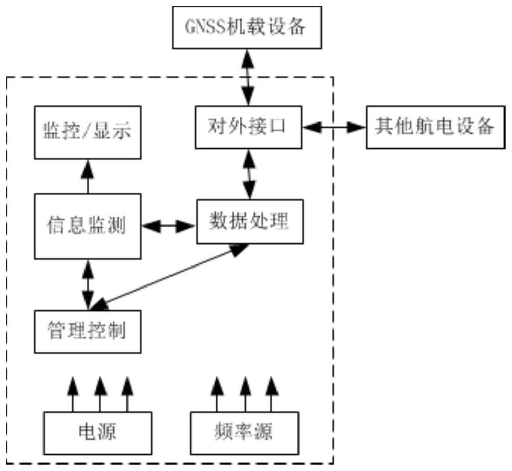
[0048] This application adopts the following technical solutions. This application includes comprehensive processing of the airborne terminal and comprehensive processing of the ground management terminal.

[0049] This application uses GNSS airborne equipment, including Beidou RNSS and GALILEO to realize passive positioning, and RDSS large-capacity inbound and outbound stations combined with ground communication network technology to report aircraft flight status, as well as related air route operations, air traffic control and other services. Among them, RNSS and RDSS are satellite navigation with independent intellectual property rights of my country, and GALILEO is invested by my country and is one of the research and development countries, so there are no safety hazards or technical conditions controlled by others at the equipment level.

[0050] The workflow of this technical solution is as follows:

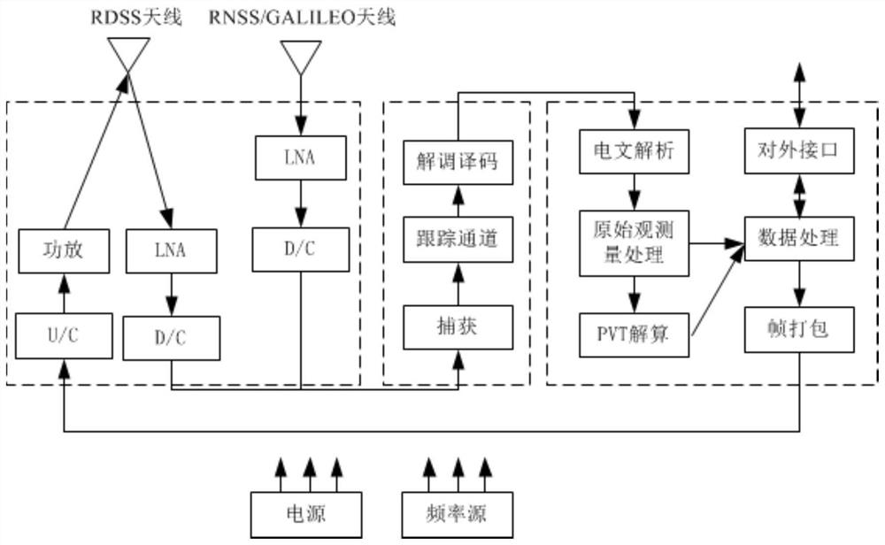
[0051] 1) Comprehensive processing The airborne terminal acquires and ...

Embodiment 2

[0062] This application uses GNSS airborne equipment, including Beidou RNSS and GALILEO to realize passive positioning, and RDSS large-capacity inbound and outbound stations combined with ground communication network technology to report aircraft flight status, as well as related air route operations, air traffic control and other services. Among them, RNSS and RDSS are satellite navigation with independent intellectual property rights of my country, and GALILEO is invested by my country and is one of the research and development countries, so there are no safety hazards or technical conditions controlled by others at the equipment level.

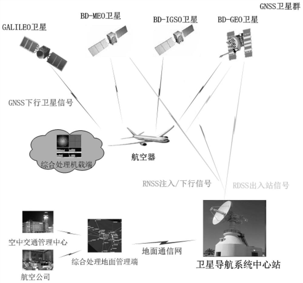
[0063] Such as figure 1 As shown, this embodiment includes: a comprehensive processing airborne terminal, a comprehensive processing ground management terminal, GNSS airborne equipment, and an established satellite navigation central station and GNSS satellite group necessary for a satellite navigation system. Among them, the GNSS airborne ...


PUM


Abstract

A GNSS-based aircraft monitoring system provided by the present application, the system includes an integrated processing airborne terminal, GNSS airborne equipment, and a satellite navigation center station, wherein the GNSS airborne equipment is used to realize aircraft positioning; the The comprehensive processing airborne terminal is used to integrate aircraft flight information and send frames to the satellite navigation central station through the Beidou RDSS system; the satellite navigation central station is used to comprehensively process aircraft flight information to realize aircraft flight display and target aircraft and surrounding aircraft groups, while sending the flight status of the aircraft to the target aircraft through the Beidou RDSS system.

Description

technical field [0001] The application belongs to the field of aviation technology, and in particular relates to a GNSS-based aircraft monitoring system and method. Background technique [0002] With the continuous growth of China's economy, China's aviation industry has achieved unprecedented development. The rapid development of the entire industry has resulted in an increase in the number of aircraft in the air. The problems of airspace management and aircraft monitoring have gradually become prominent. The monitoring methods of manned and unmanned aerial vehicles are not uniform. The monitoring of general aircraft and civil aircraft is restricted by terrain and altitude. In order to ensure the safety of air transportation, improve airspace capacity and aircraft operating efficiency, it is urgent to adopt new technologies and implement new methods in aircraft surveillance and air traffic management. [0003] The traditional aircraft radar monitoring method has limited ra...

Claims


Application Information

Patent Timeline
Patent Type & Authority Patents(China)
IPC IPC(8): G08G5/00G08G5/06H04B7/185
CPCG08G5/0043G08G5/0073G08G5/06H04B7/18502H04B7/18517H04B7/18545
Inventor 何巍巍
Owner CHINESE AERONAUTICAL RADIO ELECTRONICS RES INST
Why Eureka
Try Eureka