Road marking display method and device, electronic device and storage medium

A display method and road technology, applied in the field of information, can solve the problems of low display efficiency, incompleteness, uneven display of road markings, etc. of electronic map information, and achieve the effect of improving information display efficiency and moderate density.

Active Publication Date: 2019-07-30
TENCENT TECH (SHENZHEN) CO LTD
View PDF6 Cites 13 Cited by
  • Summary
  • Abstract
  • Description
  • Claims
  • Application Information

AI Technical Summary

Problems solved by technology

[0005] In the existing technology, in the process of offline calculation, there is no separate processing for the large-scale level, resulting in uneven, incomplete or missing road labeling at the large-scale level, resulting in low information display efficiency of the electronic map

Method used


Image

  • Road marking display method and device, electronic device and storage medium
  • Road marking display method and device, electronic device and storage medium
  • Road marking display method and device, electronic device and storage medium

Examples


Embodiment Construction

[0036] In order to make the purpose, technical solutions and advantages of the present invention clearer, the following will further describe in detail the embodiments of the present invention in conjunction with the accompanying drawings.

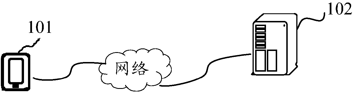
[0037] figure 1 is a schematic diagram of a map information system provided by an embodiment of the present invention, such as figure 1 As shown, the map information system includes a terminal 101 and a server 102 for providing map information services for the terminal 101.

[0038] Information exchange between the terminal 101 and the server 102 can be performed based on a network connection, and the server 102 is used for storing map information, so as to provide map information services for the terminal 101 .

[0039] The map information in the server 102 is calculated and stored offline by the server 102 . The map information includes basemap data and road labels. Basemap data includes Point of Interest (POI) information, roads, roa...


PUM


Abstract

The invention discloses a road marking display method and device, an electronic device and a storage medium, and belongs to the technical field of information. The method comprises the steps of obtaining a to-be-displayed scale level; when the scale level is smaller than a specified scale level, based on the base map data of a target area, displaying a first road mark on a road corresponding to the base map of the target area, the first road mark being a road mark determined based on offline calculation, and the target area being a to-be-displayed area corresponding to the scale level; when the scale level is greater than or equal to a specified scale level, determining a second road mark according to the road information in the base map data of the target area; and displaying the second road mark on the corresponding road of the base map of the target area. According to the invention, the road label can be uniformly and completely displayed at any scale level, and the information display efficiency of the electronic map is improved.

Description

technical field [0001] The present invention relates to the field of information technology, in particular to a road marking display method, device, electronic equipment and storage medium. Background technique [0002] With the rapid development of information technology, the application of electronic map is more and more extensive. An electronic map is a means of representing an actual map in the form of electronic data using computer technology. People can access the electronic map online or download the client of the electronic map to find the location, find the travel route and navigate, and also know the basic information of a location and the surrounding service information. The basic information includes contacts, contact information, and service information. , and even, people can view the real scene of a place through the panorama mode. [0003] The electronic map can display the shape, location and road labeling of the road according to a certain proportion. The...

Claims


Application Information

Patent Timeline
Patent Type & Authority Applications(China)
IPC IPC(8): G06F16/29
CPCG06F16/29
Inventor 徐勋
Owner TENCENT TECH (SHENZHEN) CO LTD
Why Eureka
Try Eureka