Arrangement method of exploration survey lines for railway tunnel with airborne electromagnetic method
What is AI technical title?
AI technical title is built by Patsnap AI team. It summarizes the technical point description of the patent document.
An aviation electromagnetic and layout method technology, which is applied in the direction of electric/magnetic exploration, measurement device, radio wave measurement system, etc. The effect of quality and precision, reduced number of layouts, and labor saving
Pending Publication Date: 2019-08-16
CHINA RAILWAY ERYUAN ENG GRP CO LTD
View PDF0 Cites 5 Cited by
Summary
Abstract
Description
Claims
Application Information
AI Technical Summary
This helps you quickly interpret patents by identifying the three key elements:
Problems solved by technology
Method used
Benefits of technology
Problems solved by technology
If the surveying lines are arranged at equal intervals according to the above-mentioned mineral resources exploration method, when the conditions for the exploration accuracy of the underground section of the tunnel center line are met, the surveying line spacing is required to be small and the number of surveying lines is large, but the exploration cost is high
If the survey line spacing is large, the number of survey lines is small, and the detection cost is low, but the survey accuracy of the centerline underground section cannot be satisfied
Method used
Image
Click on the blue label to locate the original text in one second.
Reading with bidirectional positioning of images and text.
Examples
Embodiment 1
[0037] Example 1—Exploration Test of Airborne Electromagnetic Method in Zheduoshan Tunnel of Sichuan-Tibet Railway
[0038] (1) Purpose of the test
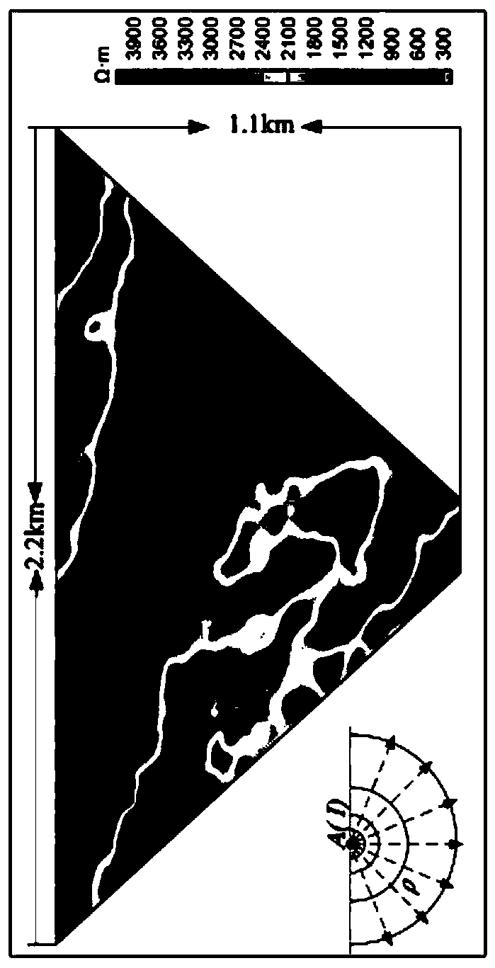
[0039] From December 22, 2018 to January 28, 2019, an airborne electromagnetic exploration test was carried out in the AK289+000-AK270+000 section of the Zheduoshan Tunnel on the Sichuan-Tibet Railway. The Zheduo Mountain Tunnel is located in an area with convenient transportation. Before the test work, ground audio magnetotelluric survey work has been carried out in most sections of the test section. The purpose of the airborne electromagnetic exploration test is to:
[0040] 1. In the exploration of main lithological boundaries and geological structures, especially in the detection of fault occurrences (apparent dip angles) and the buried depth and scale of broken, weak or water-rich rock masses, it is necessary to focus on interpreting data within the height range of the tunnel, which is the tunnel Design provides basic info...
Embodiment 2 and Embodiment 3
[0073] Example 2 and Example 3—Airborne Electromagnetic Surveying of Chaluo Tunnel and Zilashan Tunnel on Sichuan-Tibet Railway
[0074] (1) Exploration purpose
[0075] The Chaluo Tunnel and the Zila Mountain Tunnel are explored by the airborne electromagnetic method, with the purpose of ascertaining the main lithological boundaries, geological structures, especially fault occurrences (apparent dip angles) and fractured, weak, karst-developed or water-rich rocks In order to provide basic data for tunnel design, we should focus on interpreting data within the range of tunnel height and elevation.
[0076] (2) Geological profile
[0077] ①Chaluo Tunnel
[0078] The Chaluo Tunnel is located between Xide Village, Chaluo Township, Batang County, Ganzi Prefecture, and Moxi Village, Songduo Township, Batang County, with a total length of 11870m. 1460m.
[0079] The Quaternary Holocene system overlying the tunnel surface is alluvial and diluvial (Q 4 al+pl ) silty clay, pebble ...
PUM
Property
Measurement
Unit
Length
aaaaa
aaaaa
Abstract
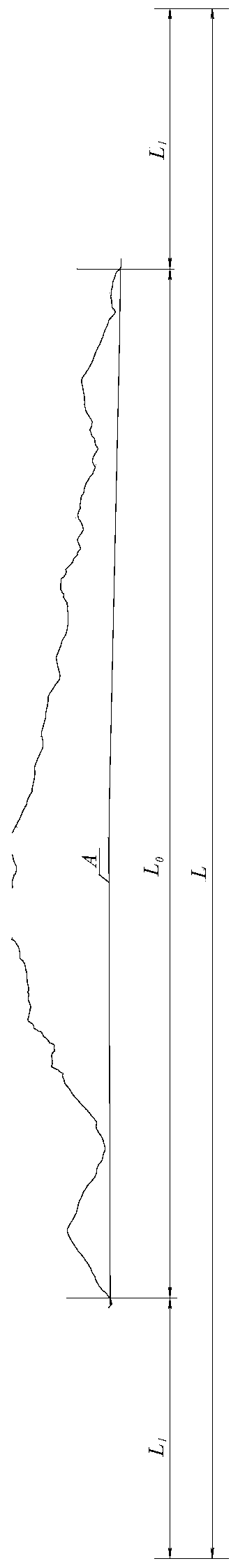
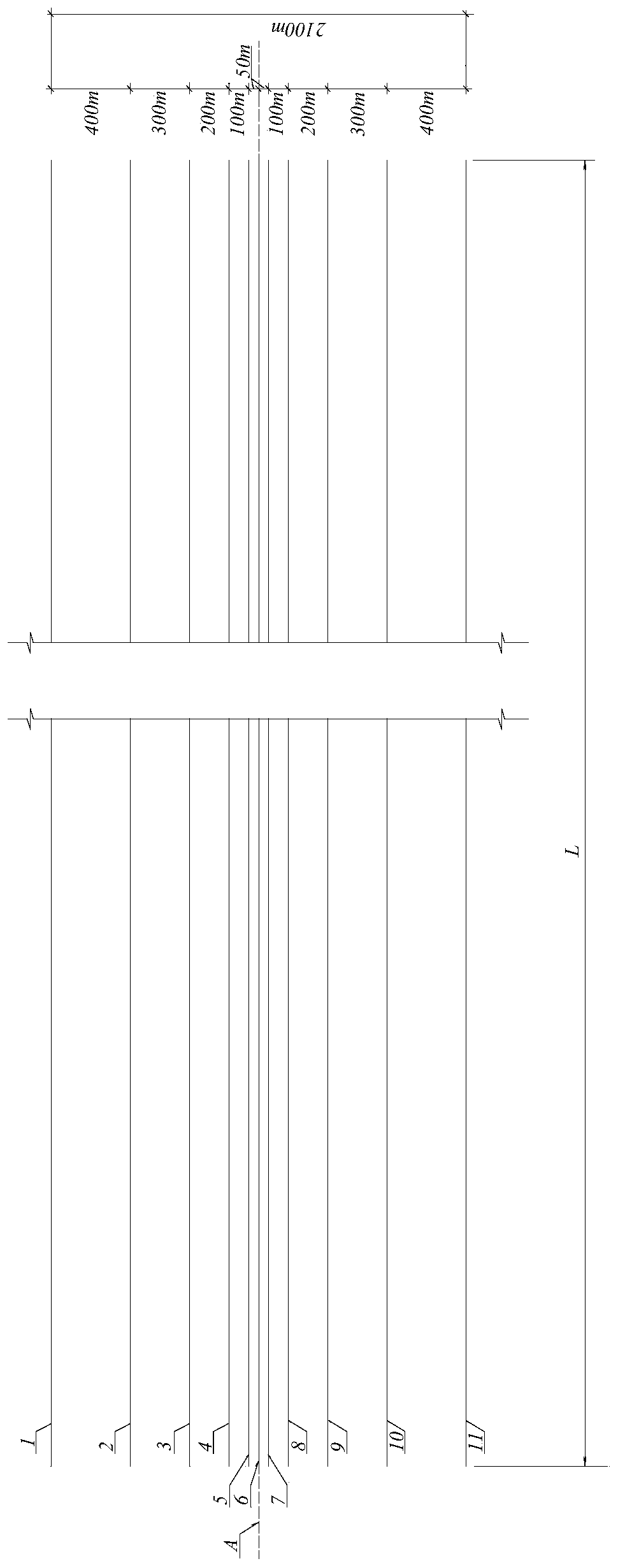
An arrangement method of exploration survey lines for a railway tunnel with an airborne electromagnetic method effectively explores geological conditions of a underground section at a center line of arailway line, so as to ensure reliability of geophysical data and realize economical efficiency, rationality and high efficiency of the exploration project as best as possible. The exploration surveylines comprise a central survey line arranged at the center line of the railway line; a left-side survey line group and a right-side survey line group that are arranged on the left side and the rightside of the center line in the direction of the railway line respectively. In the left-side survey line group and the right-side survey line group, the survey lines are symmetrically arranged with respect to the central survey line, and the spacing between the survey lines at the same side is gradually changed from the smallest spacing between the survey lines closest to the central survey line to the largest spacing between the survey lines farthest away from the the centrak survey line. The spacing between the survey line nearest to the edge in the left-side survey line group and the surveyline nearest to the edge in the right-side survey line group is twice as much as the depth of tunnel exploration. The lengths of the central survey line, the survey lines in the left-side survey linegroup and in the right-side survey line group are the sum of the tunnel length and the length of extended segment extending outward from both ends of the tunnel.
Description
technical field [0001] The invention relates to the field of applied geophysics, in particular to a method for arranging detection lines of railway tunnel airborne electromagnetic survey. Background technique [0002] The main line of the Ya'an-Linzhi section of the Sichuan-Tibet Railway is about 1,000 kilometers long, of which the total length of the tunnels is about 800 kilometers, and the ratio of tunnels to lines is as high as 80%. The line crosses the Hengduan Mountains and crosses the Jinsha River, Lancang River, and Nujiang River. It is the most dangerous railway in the world. The terrain along the line is steep and the problems of high cold and hypoxia are extremely prominent. A considerable number of personnel in the tunnel section cannot reach the line for ground geophysical survey work. Data gaps are expected to occur in 60% of the paragraphs. [0003] Airborne geophysical prospecting methods are divided into four categories: airborne gravity, aeromagnetic, aeron...
Claims
Application Information
Patent Timeline
Application Date:The date an application was filed.
Publication Date:The date a patent or application was officially published.
First Publication Date:The earliest publication date of a patent with the same application number.
Issue Date:Publication date of the patent grant document.
PCT Entry Date:The Entry date of PCT National Phase.
Estimated Expiry Date:The statutory expiry date of a patent right according to the Patent Law, and it is the longest term of protection that the patent right can achieve without the termination of the patent right due to other reasons(Term extension factor has been taken into account ).
Invalid Date:Actual expiry date is based on effective date or publication date of legal transaction data of invalid patent.

