Accumulated snow coverage measuring and calculating method based on satellite-borne multispectral remote sensing data

A technology of snow cover and remote sensing data, applied in the field of satellite remote sensing image processing and application, can solve the problems affecting the accuracy of snow cover monitoring under forest, and achieve the effect of improving the monitoring results of under forest snow cover and reducing cloud layer interference.

Active Publication Date: 2019-08-16
JILIN UNIV
View PDF9 Cites 19 Cited by
  • Summary
  • Abstract
  • Description
  • Claims
  • Application Information

AI Technical Summary

Problems solved by technology

For forest areas, in order to solve the problem that the existing optical satellite data is blocked by the forest canopy and affect the accuracy of understory snow monitoring, the present invention uses a method based on the calculation of forest transmittance to convert understory snow coverage into satellite-borne The extraction method of the reflectance function of multi-spectral data reduces the influence of forest canopy shading and effectively extracts the information of understory snow coverage

Method used


Image

  • Accumulated snow coverage measuring and calculating method based on satellite-borne multispectral remote sensing data
  • Accumulated snow coverage measuring and calculating method based on satellite-borne multispectral remote sensing data
  • Accumulated snow coverage measuring and calculating method based on satellite-borne multispectral remote sensing data

Examples


Embodiment 1

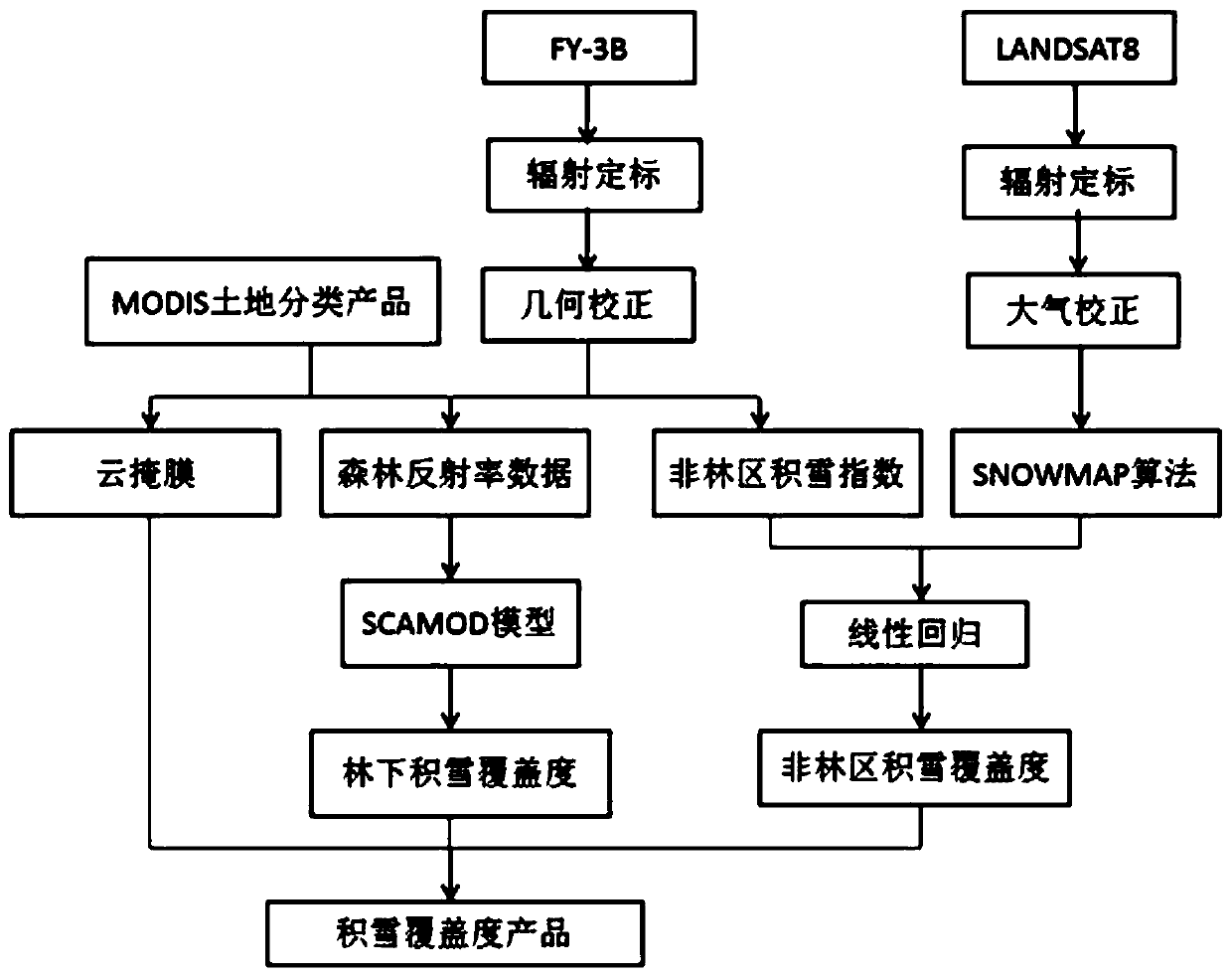
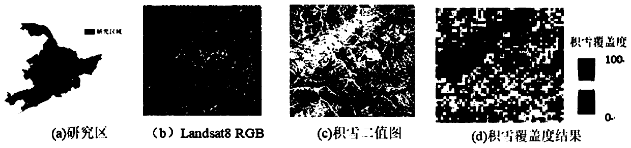
[0042] As shown in Table 1., the multispectral FY-3B data with a spatial resolution of 1 km in January 2016 was used as the experimental data, and the Northeast region was divided into forest areas and non-forest areas according to land types. For non-forest areas, use Landsat8OLI data combined with SNOWMAP algorithm to obtain "true" surface snow information, and use FY-3B data to calculate snow index; then, establish the relationship between snow index and snow coverage through linear regression; finally, The snow cover index regression equation with high precision is selected to obtain the snow cover product under cloudless conditions. For forest areas, the SCAMOD model is used to calculate the forest transmittance, and the understory snow coverage is expressed as a function of FY-3B visible light reflectance and forest transmittance to generate a more accurate understory snow coverage product, and combined with GF-2 The data were verified for snow cover.

[0043] Table 1. ...


PUM


Abstract

The invention discloses an accumulated snow coverage measuring and calculating method based on satellite-borne multispectral remote sensing data in the technical field of satellite remote sensing image processing and application. For the problems of cloud interference and under-forest accumulated snow observation existing in a current accumulated snow extraction algorithm, the method comprises thefollowing steps: firstly, dividing a selected area into a forest area and a non-forest area based on different types of land, calculating the accumulated snow coverage rate by using Landsat8 data forthe non-forest area, and performing FY-to-FY observation on the accumulated snow coverage rate; performing wave band operation on the multi-wave band data acquired by the 3B, calculating an NDSI snowindex, fitting a linear regression equation for the resampled snow coverage rate and snow index by combining a least square method, and establishing a function relationship between the snow index andthe snow coverage degree; and for the forest region, establishing a function relationship among the snow coverage, the surface reflectance and the forest transmissivity, and converting the snow coverage into a correlation function based on the forest reflectance. The influence of forest canopy shielding can be reduced, and the under-forest snow coverage information can be effectively extracted.

Description

technical field [0001] The invention belongs to the technical field of satellite remote sensing image processing and application. Background technique [0002] Snow cover is one of the most active natural elements on the Earth's surface, directly affecting surface radiation balance and energy exchange, hydrological processes, and climate change at global and continental scales. The traditional method of obtaining snow cover information is mainly to obtain corresponding data through meteorological stations, but factors such as topography or high logistics costs still have great limitations in measurement, especially in developing countries, which reduces the The ability to directly assess snow cover characteristics does not yield accurate snow cover data on a large scale. Monitoring snow parameters such as snow cover area and snow water equivalent is a challenging task. Remote sensing technology provides extremely important advantages for in-depth exploration and research o...

Claims


Application Information

Patent Timeline
Patent Type & Authority Applications(China)
IPC IPC(8): G06T7/62G01W1/14
CPCG06T7/62G01W1/14G06T2207/10032G06T2207/30192Y02A90/10
Inventor 顾玲嘉吴桐任瑞治
Owner JILIN UNIV
Why Eureka
Try Eureka