Harbor area navigation capability judgment method and system
A port area and capability technology, which is applied in the field of judging methods and systems for port navigation capability, and can solve the problems of high requirements for hardware infrastructure, long period and high quotation.
- Summary
- Abstract
- Description
- Claims
- Application Information
AI Technical Summary
Problems solved by technology
Method used
Image
Examples
Embodiment 1
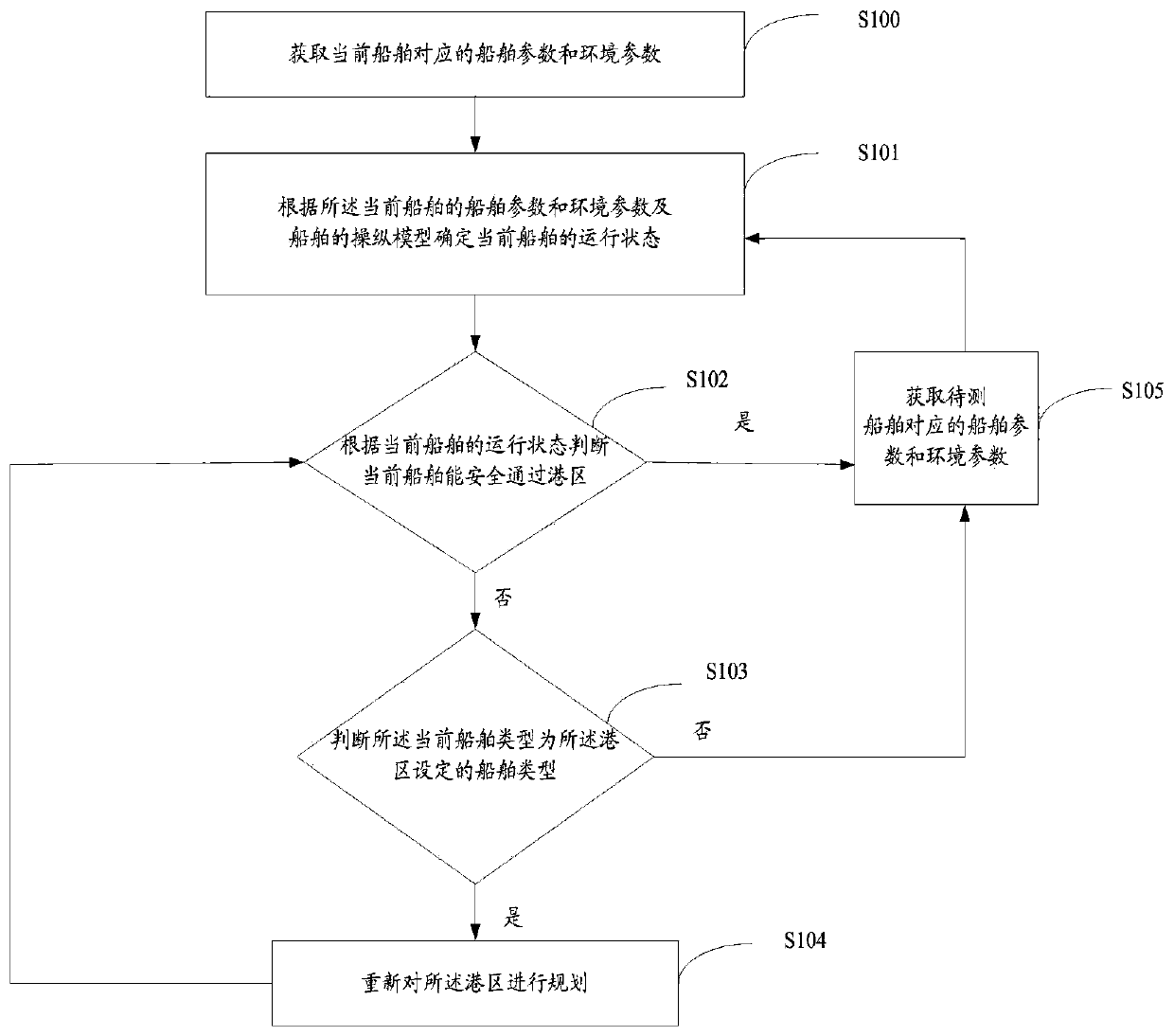
[0061] This embodiment provides a method for judging the navigability of a port area, figure 1 It is a schematic flow chart of a method for judging the navigability of a port area provided by the embodiment of the present invention, as shown in figure 1 As shown, a method for judging the navigability of a port area comprises the following steps:
[0062] S100: Obtain the ship parameters and environmental parameters corresponding to the current ship; the ship parameters include ship main dimensions and coefficients, propeller scales, rudder scales, wind area, main engine parameters, and ship types; the environmental parameters include the current ship entering the port area The wind field, wave field, current field, water depth data and channel data of the port area;
[0063] S101: Determine the operating state of the current ship according to the ship parameters and environmental parameters of the current ship and the maneuvering model of the ship; the operating state include...
Embodiment 2
[0092] This embodiment provides a system for judging the navigability of a port area, such as figure 2 According to the structural diagram of a system for judging the navigation capability of a port area provided by the embodiment of the present invention, it can be seen that a system for judging the navigation capability of a port area provided by the present invention includes a ship parameter and environmental parameter acquisition module 1 corresponding to the current ship, and a current ship operating state acquisition module. 2. The first judging module 3 and the second judging module 4 .
[0093] Wherein, the ship parameter and environmental parameter acquisition module 1 corresponding to the current ship is used to obtain the ship parameter and environmental parameter corresponding to the current ship; Host parameters and ship type; the environmental parameters include wind field, wave field, flow field, water depth data and port channel data of the current ship enter...
Embodiment 3
[0104] This embodiment provides a method for judging the navigability of a port area, and uses software for judging the navigability of a port area to realize the above process.
[0105] Figure 3-Figure 10 It is the operation interface of the software for judging the navigability of the port area, such as Figure 3-Figure 10 As shown, the left side of the operation interface of the software for judging the navigability of the port area is a sea chart, which shows the trajectory of the ship's navigation, the marine geographical environment, etc., and the right side is the parameter modification and ship control interface, which can modify the ship's main scale, marine environment, Manipulate control and other parameters to realize navigation simulation of different ships and get the final evaluation report.
[0106] Operating users can set ship parameters, marine environment parameters (including wind, current, etc.), electronic charts, etc., and the program will automaticall...
PUM
 Abstract
Description
Claims
Application Information
 - R&D
- Intellectual Property
- Life Sciences
- Materials
- Tech Scout
- Unparalleled Data Quality
- Higher Quality Content
- 60% Fewer Hallucinations
Browse by: Latest US Patents, China's latest patents, Technical Efficacy Thesaurus, Application Domain, Technology Topic, Popular Technical Reports.
© 2025 PatSnap. All rights reserved.Legal|Privacy policy|Modern Slavery Act Transparency Statement|Sitemap|About US| Contact US: help@patsnap.com


