Mapping control point measurement point cloud data-based coordinate system conversion method

A technology of point cloud data and map root points, applied in the field of surveying and mapping, can solve problems such as low efficiency, many operating procedures, and low efficiency, and achieve the effect of improving operating efficiency and reducing operating links

Active Publication Date: 2019-08-20
XIAN CHANGQING TECH ENG +1
View PDF8 Cites 5 Cited by
  • Summary
  • Abstract
  • Description
  • Claims
  • Application Information

AI Technical Summary

Problems solved by technology

[0006] For the above two schemes, scheme (1) has the problems of repeated measurement, many working procedures, and low efficiency; scheme (2) requires two operations, and has the problems of long time for scanning and setting up stations, poor freedom, and low efficiency

Method used


Image

  • Mapping control point measurement point cloud data-based coordinate system conversion method

Examples


Embodiment 1

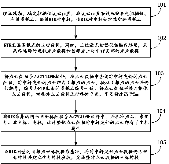
[0033] refer to figure 1 , the first embodiment of the present invention relates to a coordinate system transformation method based on map root point measurement point cloud data, comprising the following steps:

[0034] Step 101, conduct on-site survey of each station in the oil and gas field, determine the station location of the scanner, set up the 3D laser scanner at the station location, and lay out the map root point at the erection place of the 3D laser scanner, and set up RTK in each station of the oil and gas field at the same time The centering rod of the measurement system, so that the tip of the RTK centering rod is aligned with the root point of the map;

[0035] Step 102, use the RTK measurement system to collect the coordinate data of the map root point, and at the same time, use the 3D laser scanner to scan each station, collect the current point cloud data of each station and the point cloud data of the centering rod tip on the map root point ;

[0036] Step 1...

Embodiment 2

[0042] Such as figure 1 As shown, the second embodiment of the present invention relates to a coordinate system conversion method based on map root point cloud data measurement, including the following steps:

[0043] Step 101, conduct on-site survey of each station in the oil and gas field, determine the station location of the scanner, set up the 3D laser scanner at the station location, and lay out the map root point at the erection place of the 3D laser scanner, and set up RTK in each station of the oil and gas field at the same time The centering rod of the measurement system, so that the tip of the RTK centering rod is aligned with the root point of the map;

[0044] Preferably, the reconnaissance is to select the station location of the scanner, select the four corners and the central part of the oil and gas field station as the station location and set up the three-dimensional laser scanner, the selected station location has less line of sight during scanning, and can ...

Embodiment 3

[0051] refer to figure 1 , the third embodiment of the present invention relates to a coordinate system transformation method based on map root point measurement point cloud data, comprising the following steps:

[0052] Step 101, conduct on-site survey of each station in the oil and gas field, determine the station location of the scanner, set up the 3D laser scanner at the station location, and lay out the map root point at the erection place of the 3D laser scanner, and set up RTK in each station of the oil and gas field at the same time The centering rod of the measurement system, so that the tip of the RTK centering rod is aligned with the root point of the map;

[0053] Preferably, the number of map root points laid out in step 101 is at least 3, and the map root points are open and open to each other.

[0054] It should be noted that the map root points laid out are used to place points, control azimuth and elevation during station construction in the later stage. The ...


PUM


Abstract

The invention provides a mapping control point measurement point cloud data-based coordinate system conversion method. The coordinate attributes of three mapping control points are measured; point cloud positions corresponding to the three mapping control points are labeled in CYCLONE software; and the addition of point cloud coordinate attributes is realized according to corresponding relations between point clouds and coordinates. According to the method of the invention, the coordinates and point clouds of the mapping control points of a site are measured, in specific, RTK measurement and scanning are carried out on the mapping control points, and therefore, an instrument can automatically collect the point clouds of the mapping control points while collecting the coordinates of the mapping control points; and the coordinate conversion of a later stage can be realized with one-time operation, working efficiency can be effectively improved under the condition that precision is met. The coordinate conversion of the whole cloud data of the site is realized. The mapping control point measurement point cloud data-based coordinate system conversion method has the advantages of simpleprocess, quickness, convenience and high operability.

Description

technical field [0001] The invention belongs to the field of surveying and mapping, and in particular relates to a coordinate system transformation method for measuring point cloud data based on map root points. Background technique [0002] The drawings and materials usually required to be provided in the project must use the national coordinate system or the engineering coordinate system, while the 3D laser scanner uses its own coordinate system when performing scanning operations. Therefore, the scanning coordinates recorded by the 3D laser scanner need to be system to the national coordinate system or engineering coordinate system. [0003] At present, the scheme to convert the scanning coordinate system (the coordinate system that comes with the 3D scanner) into the national coordinate system or engineering coordinate system is: [0004] (1) Set the target on site, use the total station to collect the coordinate data of the target, and then perform data conversion in t...

Claims


Application Information

Patent Timeline
Patent Type & Authority Applications(China)
IPC IPC(8): G01C15/00G01S19/43
CPCG01C15/002G01S19/43
Inventor 王研何军王治军范文超侯大勇张晓林周子栋马健钧杨绥院胡伟明
Owner XIAN CHANGQING TECH ENG
Why Eureka
Try Eureka