Urban catchment area division method

A technology for catchment areas and cities, applied in image data processing, 3D modeling, instruments, etc., can solve the problem of lack of consideration of urban drainage pipe network, and achieve the effect of improving rationality and accuracy

Active Publication Date: 2019-09-13
HANGZHOU NORMAL UNIVERSITY
View PDF3 Cites 9 Cited by
  • Summary
  • Abstract
  • Description
  • Claims
  • Application Information

AI Technical Summary

Problems solved by technology

[0004] The present invention mainly solves the problem that the existing water catchment division method ignores the impact of complex underlying surfaces such as urban pipe networks, roads, and buildings on the runoff

Method used


Image

  • Urban catchment area division method
  • Urban catchment area division method
  • Urban catchment area division method

Examples


Embodiment 1

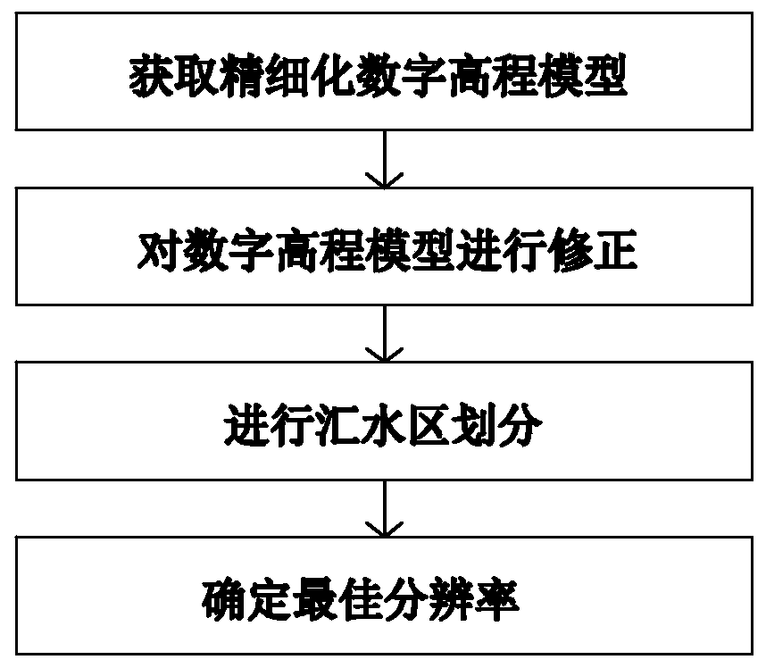
[0043] In this embodiment, a method for dividing urban water catchment areas, such as figure 1 shown, including the following steps:

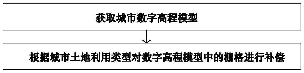
[0044] S1: Obtain a refined digital elevation model, such as figure 2 shown, including the following steps:

[0045] S11: Obtain the digital elevation model of the city by using topographic maps, high-resolution remote sensing images, urban administrative boundary data, urban land use data, etc.;

[0046] S12: Use the acquired urban land use type data to compensate the corresponding grid cells in the digital elevation model of the research area, and obtain a refined digital elevation model. The urban land use types include roads, buildings, green spaces and water channels, and road protrusions It is easy to prevent the generation of water systems, and the low-lying terrain on both sides will introduce rainfall into surrounding rivers or outfalls. Therefore, the corresponding value is added to the elevation value of the grid occupied by the r...


PUM


Abstract

The invention relates to an urban catchment area division method. The urban catchment area division method comprises the steps: obtaining a refined digital elevation model, correcting the digital elevation model, carrying out catchment area division on digital elevation models with different resolutions, and determining the optimal resolution. The urban catchment area division method has the advantages that the digital elevation model is refined, and the influence of all urban terrains on catchment area division is fully considered; the digital elevation model is corrected based on urban drainage points, and the influence of the drainage points on catchment area division is converted into elevation values, and the accuracy of catchment area division is improved; by determining the optimalresolution, the influence of DEM data with different resolutions on catchment area division is fully considered, and the rationality of catchment area division is improved.

Description

technical field [0001] The invention relates to the field of urban hydrology, in particular to a method for dividing urban catchment areas. Background technique [0002] Catchment delineation is the basis and premise of catchment data input in distributed hydrological models. Each subcatchment in a distributed hydrological model is an independent hydraulic unit in which topographical and drainage factors cause surface runoff to flow directly to a discharge point (O'Callaghan et al., 1984). The scale, accuracy, and authenticity of the flow direction of the watershed division will have an important impact on the accuracy and efficiency of the simulation (Zhou Sisi et al., 2014). When studying the urban rainstorm flooding model, due to the complex model structure, more model parameters and a larger amount of data are involved, the accuracy of watershed division will have a greater impact on the model results. At the same time, due to the highly complex, broken, and small but ...

Claims


Application Information

Patent Timeline
IPC IPC(8): G06T17/05G06Q50/26
CPCG06T17/05G06Q50/26Y02A10/40
Inventor 胡潭高沈黎达李瑶张路李东臣
Owner HANGZHOU NORMAL UNIVERSITY
Why Eureka
Try Eureka