Suppression method of offshore ground clutter and azimuth ambiguity thereof of SAR images

A technology with fuzzy orientation and ground clutter, applied in radio wave measurement systems, radio wave reflection/re-radiation, utilization of re-radiation, etc.

Active Publication Date: 2019-09-20
SHANGHAI RADIO EQUIP RES INST
View PDF9 Cites 3 Cited by
  • Summary
  • Abstract
  • Description
  • Claims
  • Application Information

AI Technical Summary

Problems solved by technology

The relevant patents that can be found are "A Method for Suppressing Spaceborne Synthetic Aperture Radar Strip Mode Azimuth Ambiguity" (application number: CN201310428893.5), but this method also loses some existing information when performing azimuth filtering
With the introduction of the concept of SAR over-navigation, Leng Xiangguang et al. proposed a method for removing near-shore azimuth blurring based on multi-temporal SAR images. Azimuth Blur Removal Method" (Application No.: CN201810033162.3), this method finds out the blurred area through the strong correlation of the ground-based source and target of two SAR images according to the autocorrelation difference between the ground clutter and its azimuth blur and the moving sea surface, Then the blurred position is removed by the binarization method, and the blurred area is restored by the image patching algorithm. Although this method can remove the azimuth blur caused by the clutter near the coast to some extent, when the blurred area covers When there is useful information on the sea surface, this method also removes this useful information at the same time, which undoubtedly produces a false alarm phenomenon when detecting near the coast

Method used


Image

  • Suppression method of offshore ground clutter and azimuth ambiguity thereof of SAR images
  • Suppression method of offshore ground clutter and azimuth ambiguity thereof of SAR images
  • Suppression method of offshore ground clutter and azimuth ambiguity thereof of SAR images

Examples


Embodiment Construction

[0019] based on the following Figure 1 to Figure 5 , specifically explain the preferred embodiment of the present invention.

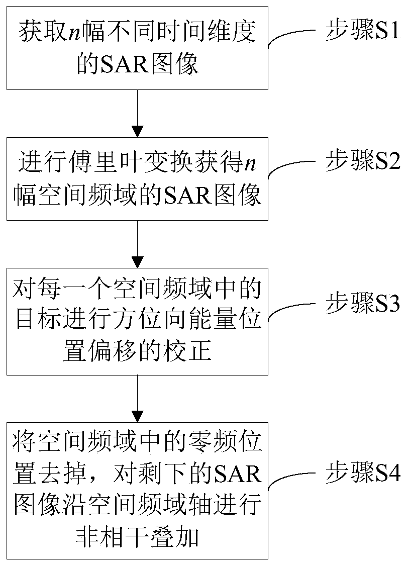
[0020] Such as figure 1 As shown, the present invention provides a method for suppressing near-coast surface clutter and azimuth blurring thereof of a SAR image, comprising the following steps:

[0021] Step S1, at T 1 moment, T 2 moment, ..., T n The SAR images of the same scene area are acquired by radar at all times, and n pieces of SAR images of different time dimensions are obtained. For stationary land targets, their characteristics do not change with time, because the ocean itself has dynamic characteristics. , so the position of the ocean area is different between the SAR images obtained at different times;

[0022] Step S2, performing Fourier transform on the obtained n pieces of SAR images of different time dimensions along the time dimension to obtain n pieces of SAR images in the spatial frequency domain;

[0023] In the n pieces of ...


PUM


Abstract

The invention relates to a suppression method of offshore ground clutter and azimuth ambiguity thereof of SAR images. The method comprises the following steps of: acquiring SAR images of the same scene region at different moments through radar to obtain n SAR images with different time dimensions, performing Fourier transform on the obtained n SAR images with different time dimensions along the time dimensions to obtain n SAR images in a space frequency domain, accumulating a stationary target and distance and azimuth ambiguity energy thereof in the n SAR images in the space frequency domain at a zero frequency position in the space frequency domain, removing the zero frequency position in the space frequency domain, and performing incoherent superposition on the rest SAR images along a space frequency domain axis to obtain a pure ocean SAR image from which the stationary ground clutter and the azimuth ambiguity thereof are removed. According to the method, the static ground clutter is filtered through the multi-temporal SAR images, the azimuth resolution is not lost while azimuth ambiguity is suppressed, the static ground clutter and azimuth ambiguity energy thereof are completely removed while ocean moving target information is not lost, and the phenomenon of alarm missing is prevented.

Description

technical field [0001] The invention relates to the field of synthetic aperture radar signal processing, in particular to a multi-temporal SAR image-based clutter of near-shore objects and a method for suppressing azimuth ambiguity. Background technique [0002] Synthetic aperture radar technology has the characteristics of all-weather and all-weather, and it is a widely used remote sensing technology for ground observation. Azimuth ambiguity is a major problem faced by synthetic aperture imaging radar, which is an inherent defect of SAR system. [0003] At present, there are a large number of research methods at home and abroad to remove azimuth ambiguity from SAR data. The traditional method is to suppress the sidelobe energy by using an azimuth filter to achieve azimuth ambiguity suppression. The relevant patents that can be found include "A method for azimuth ambiguity suppression for synthetic aperture radar" (application number: CN201711449591.0 ), "A SAR orientation...

Claims


Application Information

Patent Timeline
Patent Type & Authority Applications(China)
IPC IPC(8): G01S13/90
CPCG01S13/9011G01S13/9029G01S13/9027
Inventor 赵晗希王伟王卓群王志诚沈謇李芬
Owner SHANGHAI RADIO EQUIP RES INST
Why Eureka
Try Eureka