

Land utilization/covering information space-time monitoring method based on priori knowledge
A prior knowledge, land technology, applied in geographic information databases, special data processing applications, structured data retrieval, etc., can solve problems such as uncertainty in spatial analysis, and achieve the effect of ensuring continuity
- Summary
- Abstract
- Description
- Claims
- Application Information
AI Technical Summary
Problems solved by technology
Method used
Image

Examples
Embodiment
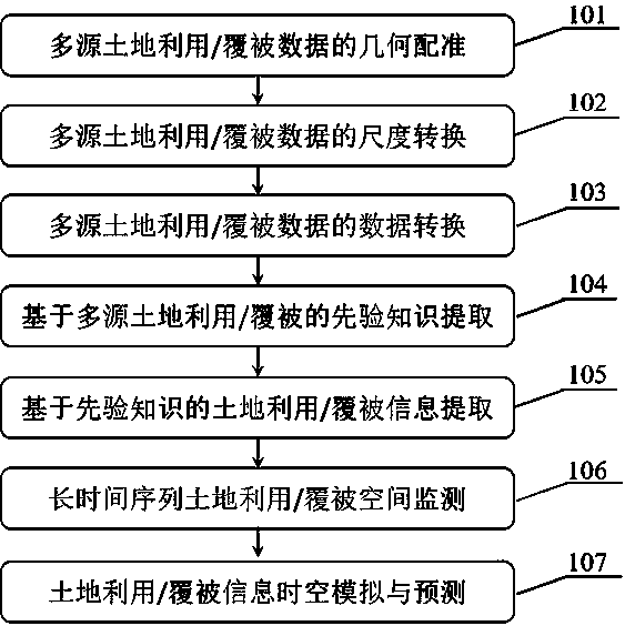
[0094] The spatio-temporal monitoring method and technology of land use / cover information based on prior knowledge, including the following steps:
[0095] (1) Geometric registration of multi-source land use / cover data (101)
[0096] (2) Scale conversion of multi-source land use / cover data (102)
[0097] (3) Data conversion of multi-source land use / cover data (103)
[0098] (4) Extraction of prior knowledge based on multi-source land use / cover (104)
[0099] (5) Extraction of land use / cover information based on prior knowledge (105)
[0100] (6) Long-term land use / cover spatial monitoring (106)
[0101] (7) Spatial-temporal simulation and prediction of land use / cover information (107)
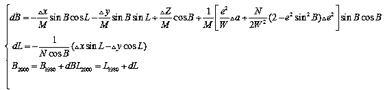
[0102] (1) Geometric registration of multi-source land use / cover data (101): The remote sensing data used in China’s third land survey mainly used high-resolution remote sensing images better than 0.2 meters and uniformly provided standards Survey base map, as well as land use status data, l...
PUM
 Abstract
Description
Claims
Application Information