LEO satellite-enhanced GNSS ionospheric normalization and fusion modeling method

A modeling method and ionospheric technology, applied in satellite radio beacon positioning systems, radio wave measurement systems, instruments, etc., can solve the problem of short effective observation arcs, uneven global distribution of GNSS ground tracking stations, and LEO satellite operating speed. wait for the question

Inactive Publication Date: 2019-09-24
WUHAN UNIV
View PDF11 Cites 17 Cited by
  • Summary
  • Abstract
  • Description
  • Claims
  • Application Information

AI Technical Summary

Problems solved by technology

[0007] (1) Using GNSS to build an ionospheric model will be limited by the uneven global distribution of GNSS ground tracking stations, especially in some land areas with harsh natural conditions and ocean areas that account for 70% of the earth's surface. Model fit extrapolation cannot compensate for this objective lack of data
[0008] (2) The ionospheric model is constructed using LEO satellites. The fast running speed of LEO satellites results in short effective observation arcs. The different orbit heights of LEO satellites lead to different detectable ranges of the ionosphere. The different observation methods of LEO satellites lead to the accuracy of extracted ionospheric TEC observations. There are different deviations from the accuracy of ionospheric TEC observations extracted based on GNSS satellite observations
[0010] Due to the different orbital heights of LEO satellites, the detectable range of the ionosphere is different, resulting in different deviations in the accuracy of ionospheric TEC observations based on LEO satellite observations and the accuracy of ionospheric TEC observations extracted based on GNSS satellite observations.

Method used


Image

  • LEO satellite-enhanced GNSS ionospheric normalization and fusion modeling method
  • LEO satellite-enhanced GNSS ionospheric normalization and fusion modeling method
  • LEO satellite-enhanced GNSS ionospheric normalization and fusion modeling method

Examples


Embodiment 1

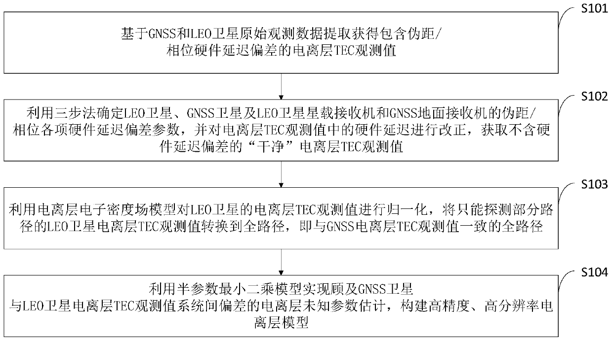
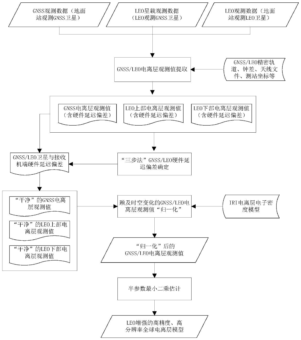
[0100] Step 1. Construct a full-path global ionospheric model based on ground-based GNSS observation data, and simultaneously estimate and obtain ground receiver hardware delay and GNSS satellite terminal hardware delay. When estimating the hardware delay of different GNSS satellite terminals, the deviation sum of the hardware delay deviation of different GNSS satellite terminals is used as a benchmark of zero.

[0101] Step 2, build the global ionospheric model of the lower part of LEO, and estimate and obtain the hardware delay of the LEO satellite terminal synchronously. In order to maintain self-consistency, the same single-layer model height as in step 1 can be selected, and the “sum of zero” of satellite hardware delay deviations of all observable LEO satellites can be selected as the baseline constraint.

[0102] Step 3: Construct the upper global ionosphere model of LEO, and simultaneously estimate and obtain the hardware delay deviation of the LEO onboard GNSS receive...

Embodiment 2

[0110] Step 1, extraction of ionospheric TEC observations based on GNSS / LEO observations.

[0111] Step 2, GNSS / LEO receiver and satellite terminal hardware delay deviation is accurately determined.

[0112] Step 3, "normalize" the GNSS / LEO ionospheric observations based on the background field model of the IRI model.

[0113] Step 4, GNSS / LEO ionospheric parameter estimation of the semiparametric compensated least squares model.

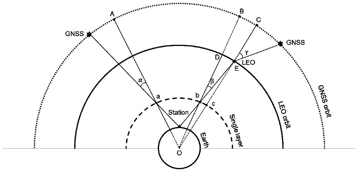
[0114] In the embodiment of the present invention, the GNSS / LEO signal in step 1 mainly includes two commonly used observations, code measurement pseudo-range and carrier phase. For the present invention, observation equation comprises three parts: the observation equation (formula 1) of GNSS satellite receiver to satellite, the observation equation (formula 2) of LEO satellite GNSS receiver to satellite and the observation equation of GNSS satellite receiver to LEO satellite (Formula 3), the specific expression is

[0115]

[0116]

[0117...


PUM


Abstract

The invention belongs to the GNSS data processing and ionospheric modeling technology field and discloses an LEO satellite-enhanced GNSS ionospheric normalization and fusion modeling method. The method comprises the following steps of extracting and obtaining an ionospheric total electron content observation value containing pseudo-range/phase hardware delay deviation based on original observation data of a GNSS satellite and an LEO satellite; determining various hardware delay deviation parameters and obtaining a "clean" ionospheric TEC observation value; normalizing the TEC observation value of the LEO satellite and converting the LEO satellite TEC observation value which can only detect partial paths into a full path; and realizing ionospheric unknown parameter estimation of the deviation with an LEO satellite TEC observation value system to construct a high-precision and high-resolution ionospheric model. In the invention, a problem of GNSS/LEO multi-source ionospheric TEC information normalization and time varying systematic deviation estimation is solved, and construction of a high-precision and high-resolution global ionospheric model is realized.

Description

technical field [0001] The invention belongs to the technical field of GNSS data processing and ionospheric modeling, in particular to a GNSS ionospheric normalization and fusion modeling method enhanced by LEO satellites. Background technique [0002] At present, the existing technologies commonly used in the industry are as follows: [0003] Global Navigation Satellite Systems (GNSS) have been widely used in ionospheric model construction and monitoring due to its advantages of high precision, wide coverage, and all-weather continuous monitoring. And with the rapid development of GPS, GLONASS, BDS, Galileo and other global navigation satellite systems and the increasing number of ground GNSS tracking stations, the accuracy and reliability of global ionospheric models have been continuously improved. However, due to the uneven global distribution of GNSS ground tracking stations, especially in some land areas with harsh natural conditions and ocean areas that account for 7...

Claims


Application Information

Patent Timeline
Patent Type & Authority Applications(China)
IPC IPC(8): G01S19/07
CPCG01S19/07
Inventor 任晓东张小红李星星赵智博陈军
Owner WUHAN UNIV
Why Eureka
Try Eureka