Method for extracting slope collapse information based on Sentinel-2A satellite remote sensing image

A technology of satellite remote sensing images and remote sensing images, which is applied to instruments, character and pattern recognition, scene recognition, etc., to achieve the effects of improving accuracy and work efficiency, broad application prospects, and easy promotion and application

Active Publication Date: 2019-10-15
HUAZHONG AGRI UNIV
View PDF11 Cites 4 Cited by
  • Summary
  • Abstract
  • Description
  • Claims
  • Application Information

AI Technical Summary

Problems solved by technology

Retrieval of Chinese and foreign literature, there is no method in the prior art to use Senti

Method used


Image

  • Method for extracting slope collapse information based on Sentinel-2A satellite remote sensing image
  • Method for extracting slope collapse information based on Sentinel-2A satellite remote sensing image
  • Method for extracting slope collapse information based on Sentinel-2A satellite remote sensing image

Examples


Embodiment Construction

[0017] In order to have a clearer understanding of the technical features, purposes and effects of the present invention, the specific implementation manners of the present invention will now be described in detail with reference to the accompanying drawings.

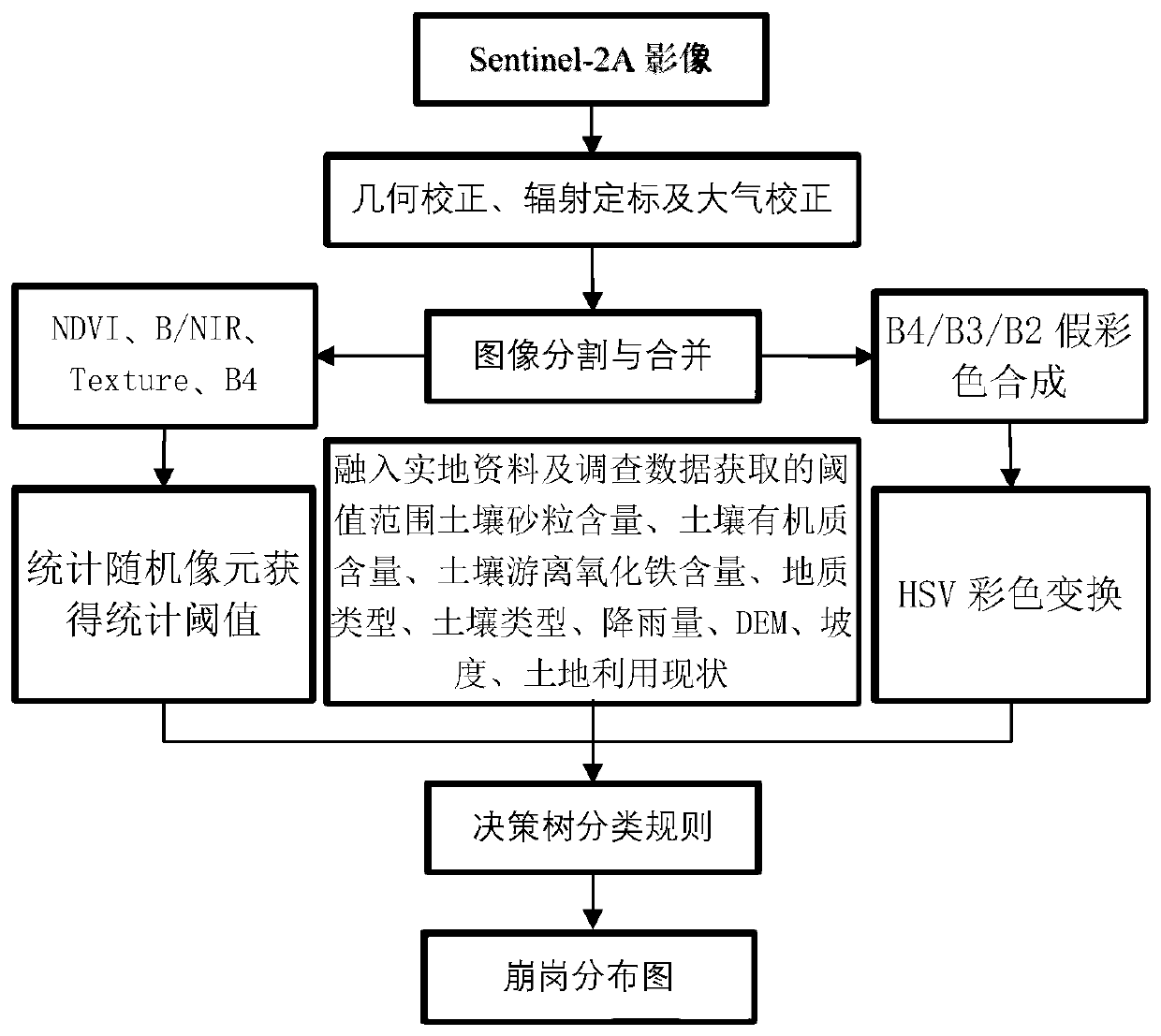
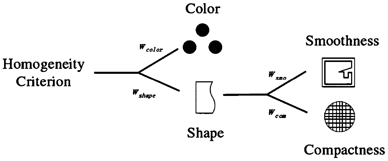
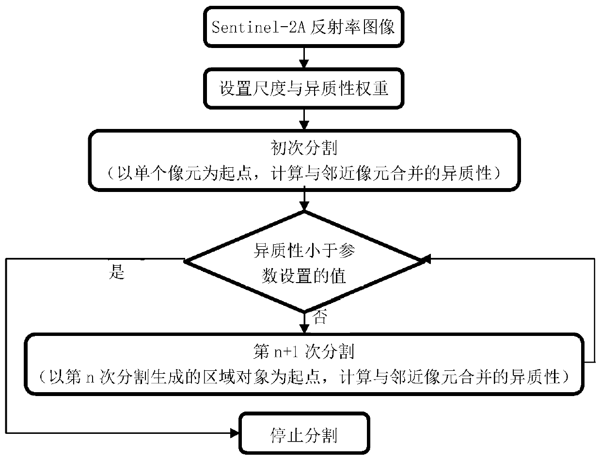
[0018] refer to figure 1 , the method for extracting collapse information based on Sentinel-2A satellite remote sensing image of the present embodiment comprises the following steps:

[0019] S1. Cut out the original Sentinel-2A remote sensing image first, and then use geometric correction, radiometric calibration and atmospheric correction to obtain the reflectance image of the remote sensing image.

[0020] The original Sentinel-2A satellite image multispectral resolution that adopts the inventive method to process is 10 meters, comprises 4 wave bands, blue wave band (447.6-545.6nm), green wave band (537.5-582.5nm), red wave band (645.5-683.5 nm) nm), infrared band (762.6-907.6nm), the image is cropped with the count...


PUM


Abstract

The invention discloses a method for extracting slope collapse information based on Sentinel-2A satellite remote sensing image. The method comprises the steps: carrying out the geometric correction, radiometric calibration and atmospheric correction of an original remote sensing image, and obtaining the reflectivity of the remote sensing image; performing graphic segmentation and combination on aSentinel-2A satellite remote sensing image reflectivity image by an object-oriented method; calculating a bare soil index and a normalized difference vegetation index by utilizing the reflectivity wave band, inverting vegetation coverage and calculating texture parameters, and performing HSV color conversion on a false color image synthesized by the b2/b3/b4 wave band; determining the threshold range of related parameters according to field data and survey data, and establishing decision tree rules in combination with statistical thresholds of randomly acquired pixel reflectivity data, textureparameters and graphic parameters, so as to quickly extracting the collapse information by utilizing the Sentinel-2A satellite remote sensing image. According to the method, the precision and the working efficiency of slope collapse field investigation can be improved, the safety of slope collapse investigation is improved, and a scientific basis can be provided for disaster prevention and reduction work in low hilly areas.

Description

technical field [0001] The invention relates to the technical field of information extraction of collapsed hill erosion, in particular to a method for extracting collapsed hillock information based on Sentinel-2A satellite remote sensing images. Background technique [0002] Benggang is a severe erosion type unique to the southern red soil area, widely distributed in the southern red soil hilly area, and it plays an important role in the problem of soil erosion. It is the result of long-term natural and man-made damage to the shallow hills and hills of granite, which lead to the collapse of the hills; the collapse of the hill is called the ecological ulcer in southern my country; the erosion and sand production of the collapse of the hill cause "sediment pollution" and serious damage to the ecological environment; The hazards of hillocks are also manifested in: harming the downstream farmlands, which may turn fertile land into sandy land; silting up river courses, affecting s...

Claims


Application Information

Patent Timeline
IPC IPC(8): G06K9/00G06K9/62
CPCG06V20/13G06F18/24323
Inventor 王家强王天巍李念盖宇函
Owner HUAZHONG AGRI UNIV
Why Eureka
Try Eureka