Remote sensing image tile generation and real-time deployment method

A remote sensing image and tile technology, which is applied in multi-channel program devices, instruments, program control design, etc., can solve the problems of low slicing efficiency, complicated deployment, and high hardware cost, and achieves fast slicing speed, easy deployment, and low hardware cost. Effect

Active Publication Date: 2019-10-18
WUHAN UNIV
View PDF6 Cites 11 Cited by
  • Summary
  • Abstract
  • Description
  • Claims
  • Application Information

AI Technical Summary

Problems solved by technology

[0004] In order to solve the problems of high hardware cost, low slicing efficiency, complex deployment and boundary problems in the prior art, the present invention provides an efficient and easy-to-implement and deploy remote sensing image tile generation and real-time deployment method

Method used


Image

  • Remote sensing image tile generation and real-time deployment method
  • Remote sensing image tile generation and real-time deployment method
  • Remote sensing image tile generation and real-time deployment method

Examples


Embodiment Construction

[0039] In order to better illustrate the present invention, the present invention will be further described in detail below in conjunction with the accompanying drawings and embodiments.

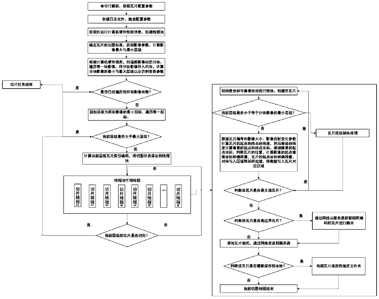
[0040] Such as figure 1 A method for generating and real-time deployment of remote sensing image tiles is shown, using a pyramid model and an image processing algorithm to slice image data, including the following steps:

[0041] Step 1, analyze the command line, determine the configuration parameter analysis method, and obtain the tile configuration parameters. The parsing methods include static mode and dynamic mode. The static mode reads the XML file of the specified path, and the dynamic mode parses the command line parameters when calling the program;

[0042] Step 2, create a log file, check various configuration parameters, and if a certain configuration parameter is empty, the program exits. Including image path, coordinate system type, tile specification, tile format, etc.;

[00...


PUM


Abstract

The invention relates to a remote sensing image tile generation and real-time deployment method, which comprises the following steps of analyzing a command line, and obtaining tile configuration parameters; creating a log file, and checking configuration parameters; running computer hardware information is obtained, and a thread pool is created; determining a tile slice standard, obtaining image parameters, and calculating the maximum and minimum levels of the image; dynamically partitioning the remote sensing image according to the hardware information of the running computer, traversing eachimage, importing the partitioned images into a memory, and calculating the minimum and maximum hierarchies and affine transformation parameters of the partitioned images; traversing each level, and carrying out tile index coding; slicing the thread pool in parallel; after each level of tile is processed, finishing the slicing of the current block; and after each image is processed, finishing slicing. The method is high in slicing speed and high in efficiency, and data can be sent through a network to be stored in a server and can also be stored locally.

Description

technical field [0001] The invention belongs to the technical field of image slicing, in particular to a method for generating and deploying remote sensing image tiles in real time. Background technique [0002] Currently, slicing is an important function in Web GIS. However, with the growth of image data and the increase of image size, the real-time performance of network geographic information system is facing challenges, and the speed of image slicing seriously affects the use of network geographic information system. At the same time, when performing image slicing, the boundary tiles only exist in some areas, but currently there are relatively few processing methods for boundary tiles. [0003] At present, how to achieve efficient slicing of image data, how to realize ultra-large-size image slicing, and how to realize tile processing in some areas of image boundaries have become urgent problems to be solved. Currently, there are two commonly used slicing methods. One i...

Claims


Application Information

Patent Timeline
Patent Type & Authority Applications(China)
IPC IPC(8): G06F9/50G06F16/29G06F16/73G06F16/75
CPCG06F9/5027G06F9/5061G06F16/29G06F16/73G06F16/75
Inventor 李治江刘亚旗乐晓峰杨振雷张过
Owner WUHAN UNIV
Why Eureka
Try Eureka