Land quality monitoring method based on aerial hyperspectrum

A quality monitoring, hyperspectral technology, applied in color/spectral property measurement, soil material testing, image detector method and image signal processing, etc., can solve the problem of reducing workload, high cost, shortening land quality monitoring cycle problem, to achieve the effect of improving accuracy and stability

Active Publication Date: 2019-10-25
北京绿土科技有限公司 +1
View PDF19 Cites 11 Cited by
  • Summary
  • Abstract
  • Description
  • Claims
  • Application Information

AI Technical Summary

Problems solved by technology

[0004] The purpose of the present invention is to solve the problems of high labor intensity, low efficiency, long cycle and high cost in the existing soil quality detection method, and provides a soil quality

Method used


Image

  • Land quality monitoring method based on aerial hyperspectrum
  • Land quality monitoring method based on aerial hyperspectrum
  • Land quality monitoring method based on aerial hyperspectrum

Examples


Embodiment

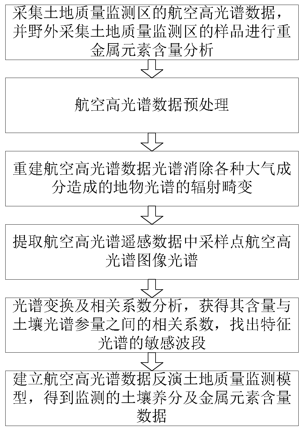
[0049] Such as figure 1 As shown, the land quality monitoring method based on aerial hyperspectral includes the following steps: Step 1. Use aerial hyperspectral imaging spectrometer to collect aerial hyperspectral data of land quality monitoring area, and collect samples from land quality monitoring area in the field to determine the content of heavy metal elements. Analysis; step 2, preprocessing the aerial hyperspectral data; step 3, reconstructing the aerial hyperspectral data spectrum to eliminate the radiation distortion of the ground object spectrum caused by various atmospheric components; step 4, extracting the aerial hyperspectral remote sensing data of the sampling points Hyperspectral image spectrum; step 5, spectral transformation and correlation coefficient analysis, obtain the correlation coefficient between its content and soil spectral parameters, and find out the sensitive band of the characteristic spectrum; step 6, establish the aerial hyperspectral data inv...


PUM


Abstract

The invention discloses a land quality monitoring method based on an aerial hyperspectrum. The method comprises the following steps of step1, collecting aerial hyperspectral data of a land quality monitoring area, and collecting a sample of the land quality monitoring area in the field and carrying out heavy metal element content analysis; step2, pre-processing the aerial hyperspectral data; step3. reconstructing an aerial hyperspectral data spectrum to eliminate radiation distortion of ground and object spectrum caused by various atmospheric components; step4, extracting an aerial hyperspectral image spectrum of a sampling point in aerial hyperspectral remote sensing data; step 5, carrying out spectral transformation and correlation coefficient analysis, obtaining a correlation coefficient between a content and a soil spectral parameter, and finding a sensitive band of a characteristic spectrum; and step6, establishing aerial hyperspectral data to invert a land quality monitoring model, and acquiring a monitored soil nutrient and metal element content data. During application, a wide range of land-based data can be accurately acquired, a workload can be reduced, a land quality monitoring period is shortened, and cost is reduced.

Description

technical field [0001] The invention relates to the field of ecological environment monitoring, in particular to a land quality monitoring method based on aerial hyperspectral. Background technique [0002] The current high-intensity predatory development has seriously degraded the soil, which is mainly reflected in the decline of farmland soil nutrients, nutrient imbalance, and local heavy metals exceeding the standard. Therefore, carrying out land and soil quality evaluation research is of great significance to the standardized management, effective use and protection of land resources, and to ensuring food security. [0003] The traditional soil quality detection method needs to invest a lot of manpower and material resources to carry out geochemical sampling in the study area. Take 1:50,000 geochemical sampling as an example: the sampling density is 4-8 points / km 2 , each land sampling point takes more than one hour, and field monitoring usually requires long-term and ...

Claims


Application Information

Patent Timeline
IPC IPC(8): G01N21/25G01N21/31G01N33/24
CPCG01N21/25G01N21/31G01N33/24G01N2021/1793G01N2021/1765Y02A40/10
Inventor 常睿春王建华郭科李一平
Owner 北京绿土科技有限公司
Why Eureka
Try Eureka