Road vision detection method combined with laser point cloud data

A technology of laser point cloud data and point cloud data, applied in neural learning methods, instruments, biological neural network models, etc., can solve the problems of unable to achieve information complementarity, unable to improve road detection accuracy and robustness, etc.

Active Publication Date: 2019-10-25
UNIV OF ELECTRONICS SCI & TECH OF CHINA
View PDF10 Cites 33 Cited by
  • Summary
  • Abstract
  • Description
  • Claims
  • Application Information

AI Technical Summary

Problems solved by technology

[0007] In view of the problems of the above research, the purpose of the present invention is to provide a road vision detection method combined with laser point cloud data to solve the problem of multi-sensor fusion in the prior art, which cannot realize information complementation and thus cannot improve the accuracy and robustness of road detection The problem

Method used


Image

  • Road vision detection method combined with laser point cloud data
  • Road vision detection method combined with laser point cloud data
  • Road vision detection method combined with laser point cloud data

Examples


Embodiment

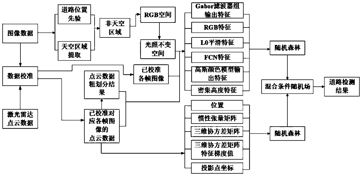
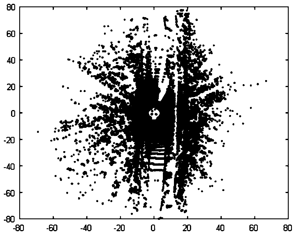
[0176] According to the spatial relationship between point cloud data and image data, the point cloud data acquired by the laser radar and the image data acquired by the camera are jointly calibrated to obtain the data-level fusion of point cloud data and image data, in which the image data includes a frame image, such as figure 2 shown; corresponding figure 2 The uncalibrated point cloud data, such as image 3 shown;

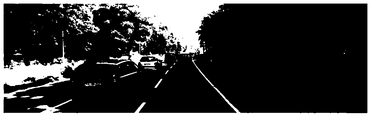
[0177] Road division is performed on each frame image in the image data to obtain a rough division image of the area where the road is located, such as Figure 4 As shown, the coarsely divided image is converted to the illumination invariant space, and the illumination invariant space image is obtained;

[0178] According to M estimation sample consistency, plane fitting is performed on the point cloud data corresponding to each frame image after data level fusion, and the rough division result of point cloud data on the road area is obtained, as shown in ...


PUM


Abstract

The invention discloses a road vision detection method combined with laser point cloud data, belongs to the field of unmanned driving, and solves the problem of multi-sensor fusion in the prior art. The method comprises the steps of performing data-level fusion on the point cloud data and the image data; performing road division on each frame of image in the image data, and performing conversion after division to obtain an illumination-invariant space image; according to the M estimation sample consistency, performing plane fitting on the point cloud data after data level fusion to obtain a point cloud data coarse division result; performing road feature extraction on each frame of image, the illumination-invariant space image and the point cloud data coarse division result of the image data after data level fusion and the point cloud data after data level fusion corresponding to each frame of image; respectively sending the extracted road features into two random forests for training,and obtaining probability output of each pixel point and probability output of each point cloud data; and constructing each point cloud-image mixed conditional random field to obtain a road area. Themethod is used for road vision detection.

Description

technical field [0001] A road vision detection method combined with laser point cloud data is used for road vision detection and belongs to the field of unmanned driving. Background technique [0002] Road detection is a basic research task in driving environment perception, and it plays a vital role in ensuring vehicle driving safety and realizing high-level automatic driving. However, in the real outdoor environment, road detection faces challenges such as complex weather, lighting, shadows, and scene diversity. In the face of these problems, road detection algorithms are required to have strong scene adaptation and resistance to complex weather, lighting, and shadows. The robustness of changes is used to ensure the safe and stable driving of intelligent vehicles. [0003] Road detection methods are divided into road detection based on single sensor and road detection based on multi-sensor fusion. Due to the inevitable defects of using a single sensor, road detection meth...

Claims


Application Information

Patent Timeline
Patent Type & Authority Applications(China)
IPC IPC(8): G06K9/00G06K9/62G06N3/04G06N3/08
CPCG06N3/08G06V20/588G06N3/045G06F18/251G06F18/253G06F18/214
Inventor 马沪敏彭真明杨心怡陈明彭凌冰陶冰洁杨春平赵学功蒲恬何艳敏袁国慧
Owner UNIV OF ELECTRONICS SCI & TECH OF CHINA
Why Eureka
Try Eureka