Three-dimensional road curve reconstruction method based on vehicle-mounted mobile laser scanning point cloud

A technology of laser scanning and vehicle-mounted movement, which is applied in 3D modeling, image data processing, instruments, etc., can solve problems such as road construction quality evaluation that cannot be used, and achieve the effect of simple, convenient and reliable three-dimensional information extraction method

Active Publication Date: 2019-10-25
XIAMEN UNIV
View PDF7 Cites 4 Cited by
  • Summary
  • Abstract
  • Description
  • Claims
  • Application Information

AI Technical Summary

Problems solved by technology

In addition, the curves reconstructed by many methods are general curves (such as basic sp...

Method used


Image

  • Three-dimensional road curve reconstruction method based on vehicle-mounted mobile laser scanning point cloud
  • Three-dimensional road curve reconstruction method based on vehicle-mounted mobile laser scanning point cloud
  • Three-dimensional road curve reconstruction method based on vehicle-mounted mobile laser scanning point cloud

Examples


Embodiment

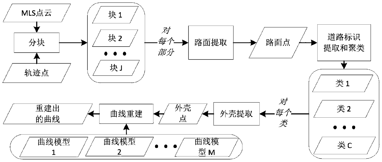
[0044] figure 1 Shows the implementation process of this embodiment, refer to figure 1 As shown, the present invention discloses a three-dimensional highway curve reconstruction method based on a vehicle-mounted mobile laser scanning point cloud, which includes the following steps:

[0045] S1. Using the driving trajectory information of the laser scanning vehicle to divide the original point cloud of the vehicle-mounted mobile laser scanning into several sub-point clouds:

[0046] This step also divides the data into blocks, refer to figure 2 As shown, the original vehicle-mounted mobile laser scanning point cloud usually contains a large number of points (several millions or tens of millions), and it is very difficult to process so many points at the same time. The usual approach is to divide the original vehicle-mounted mobile laser scanning point cloud into several small point clouds for processing separately. The goal of this embodiment is road curve reconstruction, so it is ...


PUM


Abstract

The invention discloses a three-dimensional road curve reconstruction method based on a vehicle-mounted mobile laser scanning point cloud. The method comprises the following steps: S1, dividing a vehicle-mounted mobile laser scanning original point cloud into a plurality of sections of sub-point clouds; S2, performing road surface extraction on each section of sub-point cloud to obtain a road surface point set; S3, performing road sign extraction on the road surface point set to obtain a road sign point set; S4, clustering the road sign point set to obtain a plurality of road sign sub-point sets; S5, performing shell extraction on each road sign sub-point set to obtain a shell point set; S6, respectively carrying out model fitting on the basic three-dimensional road curve model and the shell point set specified by the standard to obtain candidate curves; and S7, comparing the candidate curves to obtain an optimal curve. According to the method, the type of the road curve can be automatically and robustly recognized and the parameters of the three-dimensional road curve meeting the geometric design standard of the road can be accurately estimated under the condition that a large number of outliers are contained in the data. The method can be applied to the fields of road construction quality evaluation and the like.

Description

Technical field [0001] The invention relates to a method for reconstructing a three-dimensional highway curve, in particular to a method for reconstructing a three-dimensional highway curve using a vehicle-mounted mobile laser scanning point cloud. Background technique [0002] The curve shape of highway has an important influence on highway construction, traffic safety and driving comfort. The goal of highway curve reconstruction is to estimate the geometric information (that is, the type and parameter value of the curve) of the curve of the built highway. Therefore, highway curve reconstruction can be applied to many applications such as digital surveying and mapping, autonomous driving, highway geometric design, traffic accident analysis, and highway construction quality assessment. [0003] There are currently two main types of data that can be used to reconstruct highway curves. The first type is ground measurement data, mainly using real-time kinematic GPS (Global Positionin...

Claims


Application Information

Patent Timeline
IPC IPC(8): G06T17/00G06T5/00
CPCG06T17/00G06T5/002G06T2207/10028
Inventor 李军张宗良陈一平王程
Owner XIAMEN UNIV
Why Eureka
Try Eureka