
Aircraft monocular vision scale estimation method and device, aircraft navigation system and aircraft

A technology of monocular vision and scale estimation, which is applied in the field of aircraft and can solve problems such as inability to achieve

Active Publication Date: 2021-07-13
BEIJING JINGDONG SHANGKE INFORMATION TECH CO LTD +1
View PDF0 Cites 0 Cited by
  • Summary
  • Abstract
  • Description
  • Claims
  • Application Information

AI Technical Summary

Problems solved by technology

Many scholars have conducted research in this area. For example, the classic algorithm PTAM (Parallel Tracking and Mapping, Tracking and Drawing) in monocular vision SLAM uses artificial operations to estimate the scale, and translates and fixes along the coordinate axis during its initialization process. The distance is used to estimate the scale through this known distance, but such a method requires manual initialization with human intervention, and cannot achieve complete autonomy

Method used


Image

  • Aircraft monocular vision scale estimation method and device, aircraft navigation system and aircraft
  • Aircraft monocular vision scale estimation method and device, aircraft navigation system and aircraft
  • Aircraft monocular vision scale estimation method and device, aircraft navigation system and aircraft

Examples


Embodiment Construction

[0043] The technical solution of the present disclosure will be described in further detail below with reference to the drawings and embodiments.

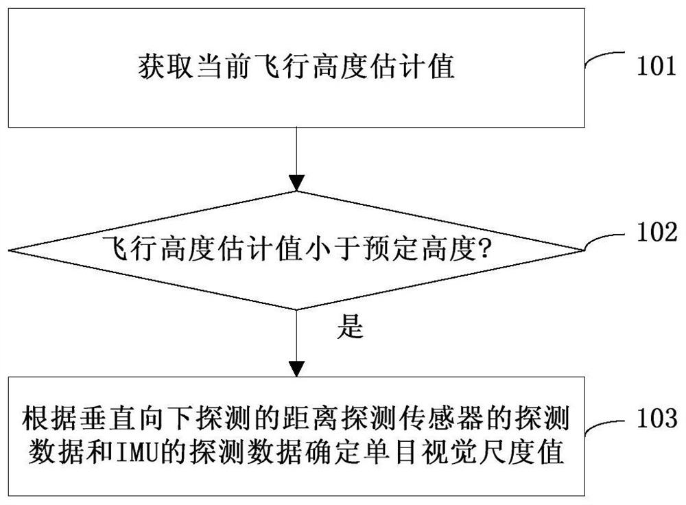
[0044] The flow chart of an embodiment of the aircraft monocular vision scale estimation method of the present disclosure is as follows figure 1 shown.

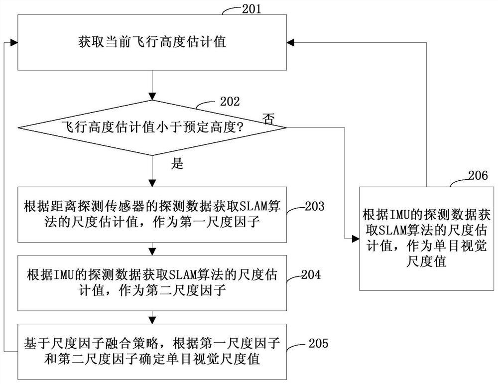
[0045] In step 101, an estimated current flight height is acquired. In an embodiment, the estimated value of the flying height may be obtained by a distance detection sensor installed on the aircraft with a detection direction vertically downward. When the flight height exceeds the measurement range of the sensor and the detection cannot be performed, the estimated value of the flight height may be a predetermined threshold value by default, and the predetermined threshold value is higher than the predetermined height in step 102 .

[0046] In step 102, the flight altitude estimate is compared to a predetermined altitude. Step 103 is executed when the estimated flight height is...


PUM


Abstract

The disclosure proposes a method and device for estimating a monocular visual scale of an aircraft, an aircraft navigation system and flight, and relates to the technical field of aircraft. The method for estimating the scale of the aircraft monocular vision of the present disclosure includes: obtaining the estimated value of the current flying height; when the estimated value of the flying height is less than the predetermined height, detecting the detection data of the sensor and the detection of the inertial measurement unit IMU according to the vertically downward detection distance The data determine the monocular vision scale value. Through this method, when the flying height of the aircraft is lower than the predetermined height, the distance detection sensor and the IMU can be used to obtain the monocular visual scale value. On the one hand, no manual participation is required, which improves the degree of automation. Combining the advantages of distance detection sensors and IMUs, it reduces the error caused by a single measurement method and improves the accuracy of scale estimation.

Description

technical field [0001] The present disclosure relates to the field of aircraft technology, in particular to an aircraft monocular vision scale estimation method and device, an aircraft navigation system, and an aircraft. Background technique [0002] Accurate pose estimation is critical for autonomous flight control of aircraft such as small rotorcraft. At present, most aircraft use GNSS (Global Navigation Satellite System, Global Satellite Navigation System) and IMU (Inertial Measurement Unit, Inertial Measurement Unit) for pose estimation, but it cannot work normally when the GNSS signal strength and accuracy are not good. , through visual SLAM (Simultaneous Localization and Mapping, real-time positioning and map construction) for pose estimation, it can solve the problem of pose estimation of the aircraft when satellite signals cannot be obtained. [0003] For monocular vision SLAM, monocular vision scale estimation is the prerequisite for accurate pose estimation. At pr...

Claims


Application Information

Patent Timeline
Patent Type & Authority Patents(China)
IPC IPC(8): G01C21/16G01C21/20
CPCG01C21/165G01C21/20
Inventor 门春雷刘艳光张文凯陈明轩郝尚荣郑行徐进韩微
Owner BEIJING JINGDONG SHANGKE INFORMATION TECH CO LTD
Learn More