Method and system for establishing storm surge overtopping and flooding analysis based on GIS technology

A storm surge and floodplain technology, applied in the field of storm surge floodplain and inundation models, can solve problems such as failure to achieve accuracy, calculation of storm surge flooding or flooding, and low accuracy of floodplain process.

Active Publication Date: 2019-11-05
中国地质大学深圳研究院
View PDF6 Cites 6 Cited by
  • Summary
  • Abstract
  • Description
  • Claims
  • Application Information

AI Technical Summary

Problems solved by technology

[0005] However, the traditional storm surge simulation is relatively rough and fails to achieve the ideal accuracy. The traditional method does not use the possible maximum storm surge water level and seawall elevation to calcul

Method used


Image

  • Method and system for establishing storm surge overtopping and flooding analysis based on GIS technology
  • Method and system for establishing storm surge overtopping and flooding analysis based on GIS technology
  • Method and system for establishing storm surge overtopping and flooding analysis based on GIS technology

Examples


Embodiment Construction

[0044] In order to have a clearer understanding of the technical features, purposes and effects of the present invention, the specific implementation manners of the present invention will now be described in detail with reference to the accompanying drawings.

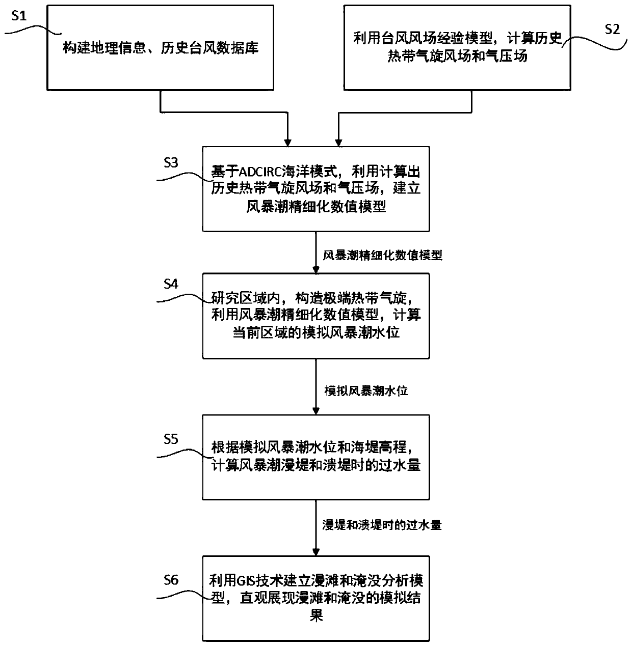
[0045] Please refer to figure 1 , which is a flow chart of the storm surge floodplain and inundation analysis method disclosed in the present invention, the method specifically includes the following steps:

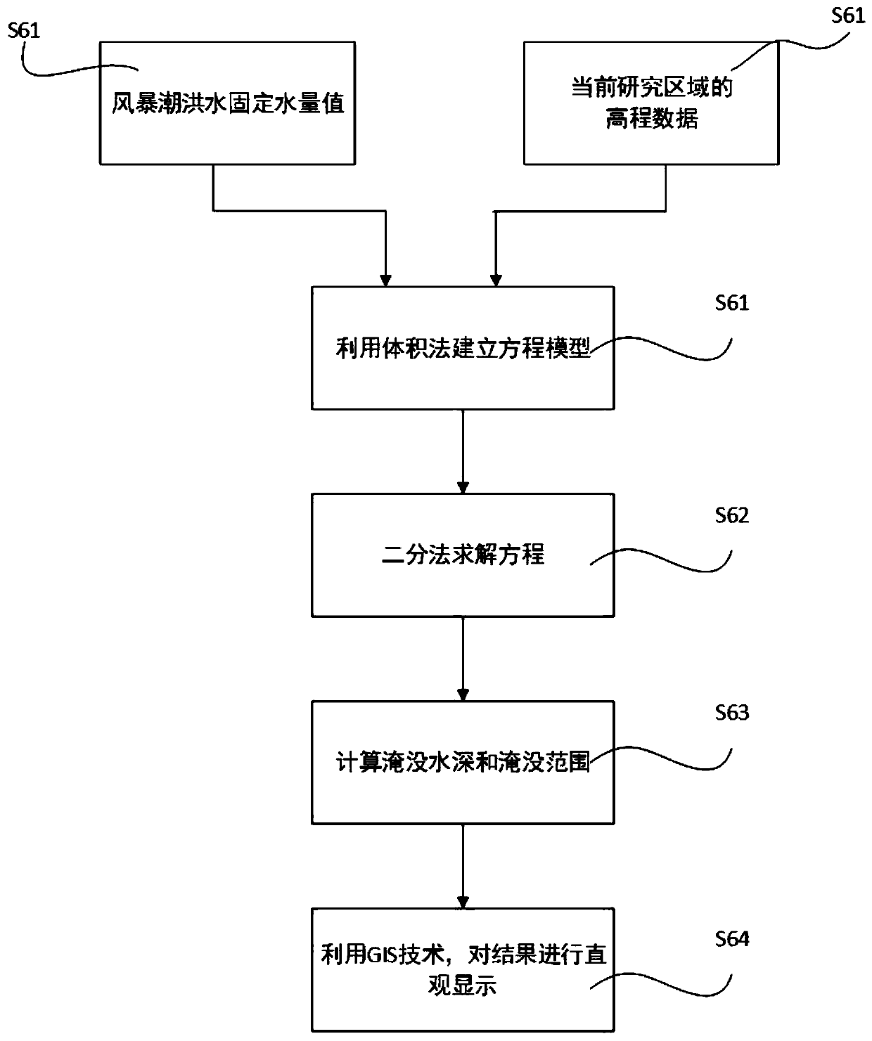
[0046] S1. Determine the research area, organize the basic geographic information data and historical tropical cyclone data in the area, and construct geographic information and historical typhoon databases; among them, the geographic information database of the research area includes high-precision DEM, sea water depth distribution, and coastal warning data , community or village population distribution, land use status secondary classification spatial distribution data, and important carrier data; the content of ...


PUM


Abstract

The invention discloses a method and a system for establishing storm surge overtopping and flooding analysis based on a GIS (Geographic Information System) technology, and the method comprises the following steps: firstly, reconstructing historical tropical cyclone data of a research area by utilizing constructed geographic information and a historical typhoon database and adopting a typhoon windfield empirical model; secondly, determining a calculation range of a research area, and establishing a storm surge refined numerical model based on an ADCIRC ocean mode; and finally, after the reliability and accuracy of the numerical model are determined, constructing an extreme tropical cyclone of the research area, designing the maximum water increase caused by the extreme tropical cyclone tomeet the astronomical high tide level, performing coupling calculation to obtain the possible maximum storm surge water level of the simulation area, and calculating the overtopping or collapsing water flow of the storm surge in combination with the seawall elevation. The method has the advantages that on the premise that the water flow calculation during storm surge overtopping and dike collapsing is increased, the volume method is adopted for calculating the water level of the submerged area, the GIS technology is utilized for building the overtopping and submerging analysis model, and the overtopping and submerging simulation result is visually displayed.

Description

technical field [0001] The invention relates to the technical fields of marine science and marine engineering, in particular to a GIS-based storm surge floodplain and inundation model. Background technique [0002] Storm surge is a huge natural disaster phenomenon from the sea, which refers to the abnormal rise of the sea level caused by strong atmospheric disturbances such as strong winds and sudden changes in air pressure. Storm surges are often accompanied by astronomical tides (normal tide levels) and short-period (several seconds) waves, causing the tide levels to skyrocket and even seawater to overflow, causing disasters. [0003] Storm surge can be divided into two categories, namely typhoon storm surge and extratropical storm surge. my country is a country where natural disasters occur frequently, especially marine disasters, and storm surge disasters rank first in marine disasters, often occurring in economically developed coastal areas. The east of my country is ...

Claims


Application Information

Patent Timeline
IPC IPC(8): G06F17/50G06F16/29
CPCG06F16/29Y02A10/40
Inventor 牟林尹哲元翔飞高佳王道胜
Owner 中国地质大学深圳研究院
Why Eureka
Try Eureka