Multi-water-level-station-linked inland river water level intelligent prediction method

A technology for intelligent forecasting and water level, applied in forecasting, neural learning methods, image data processing, etc.

Pending Publication Date: 2019-11-05
DALIAN MARITIME UNIVERSITY
View PDF4 Cites 10 Cited by
  • Summary
  • Abstract
  • Description
  • Claims
  • Application Information

AI Technical Summary

Problems solved by technology

[0005] In response to the above problems, the application number is 201810464065.X, and the patent name is a method for predicting the upstream and downstream water levels of cascade power stations. This invention is to predict the water level of the power station, but only uses the water level of the upstream power station, and the water level value of the downstream power station is also easy to observe

Method used


Image

  • Multi-water-level-station-linked inland river water level intelligent prediction method
  • Multi-water-level-station-linked inland river water level intelligent prediction method
  • Multi-water-level-station-linked inland river water level intelligent prediction method

Examples


Embodiment 1

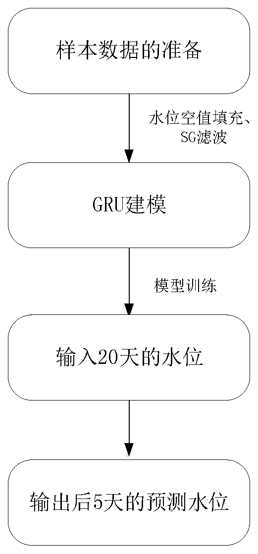
[0080] When analyzing time-series data, the quality of the data has a great influence on the analysis results. A piece of low-quality time-series data, no matter how ingenious the time-series model, is difficult to achieve the desired analysis results. In this embodiment, the sample data is preprocessed as follows.

[0081] Specifically, in step S1, the vacant value is filled using the average value. In this embodiment, the water levels of the 4 points around the vacant item are used to take the average, such as the water level x 1 ,x 2 ,x 3 ,x 4 ,x 5 , where x 3 is a blank item, the filling value is:

[0082]

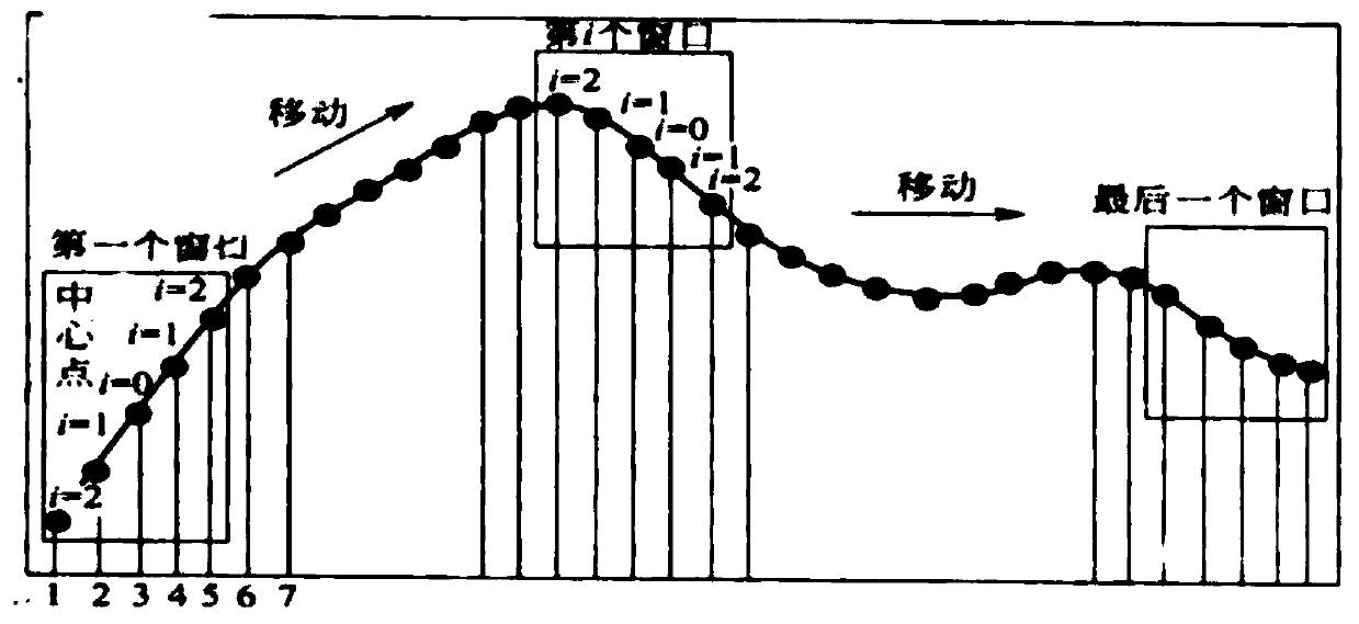
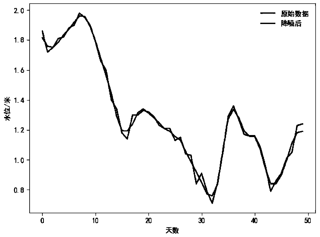
[0083] In this embodiment, five-point smoothing (with a window width of 5) is taken as an example to illustrate the smoothing process. Such as figure 2 As shown, the SG filter smoothing process in step S1 includes:

[0084] Step S11: For the data points in the window, use the following formula to fit, k-1 is the number of fittings:

[0085] p(n)=a 0 +a 1...

Embodiment 2

[0092] Taking the Yangtze River as an example, the joint prediction model of three water level stations in this scheme is explained. Such as Figure 4 As shown, there are water level observation stations in Nanjing, Wuhu and Anqing along the Yangtze River, and Wuhu is located between Nanjing and Anqing.

[0093] In this embodiment, the GRU-based linkage prediction model of three water level stations is constructed, such as Figure 5 As shown, including the input layer, the first GRU layer, the second GRU layer and the output layer;

[0094] The input dimension of the input layer [(None,20,3)], where None represents the batch_size of data input to the network once (for example: set to 128), and 20 represents the step size, that is, the water level data of the past 20 days is used as input; 3 is the number of features; that is, the water level value input every day contains 3 features, that is, the 3 water level values ​​​​arranged in sequence by the 3 water level stations in ...

Embodiment 3

[0108] The training of the model is divided into two parts, forward propagation and back propagation. The purpose of forward propagation is to give the output of the model, and back propagation is used to update the network weights. According to the above model structure, the focus of forward propagation and backpropagation is mainly on the GRU model, and the following assumes that the time step is 20 (such as Figure 8 Shown), the training of the GRU layer is described.

[0109] Forward propagation in step S3 such as Figure 6 As shown, it is determined by the following formula, and finally the output y is obtained t .

[0110] r t =σ(W r [h t-1 ,x t ])

[0111] z t =σ(W z [h t-1 ,x t ])

[0112]

[0113]

[0114] the y t =σ(W o h t )

[0115] Among them, [h t-1 ,x t ] means that the two vectors h t-1 ,x t Stitched together vertically, h t-1 represents the hidden information of the water level, x t Indicates the input water level data, W r ,W z ...


PUM


Abstract

The invention provides a multi-water-level-station-linked inland river water level intelligent prediction method. The method comprises the steps of S1, preparing sample data, and performing vacancy value filling and SG filtering smoothing processing on the sample data; S2 constructing a three-water-level-station linkage prediction model based on the GRU; and S3, training and predicting the three-water-level-station linkage prediction model constructed in the step S2 by adopting forward propagation and reverse propagation. According to the technical scheme, a water level prediction model is constructed by using a GRU (gated recurrent unit) recurrent neural network. The difference between the scheme and the prior art is that the time relationship of water level values and the space relationship between water level stations are considered. In order to predict the water level value of a certain water level station. The scheme not only depends on the historical data of the water level station, but also utilizes the historical data of the adjacent upstream and downstream water level stations to assist in establishing a prediction model. Therefore, the error of single station data is reduced. The general law of water level change is better reflected and the accuracy of water level prediction is improved.

Description

technical field [0001] The invention relates to the technical field of water level prediction, in particular to an intelligent prediction method for inland river water level linked by multiple water level stations. Background technique [0002] my country's inland waterways are rich in resources, including the Yangtze River, Pearl River, and the Beijing-Hangzhou Grand Canal. The total navigable mileage has reached 127,000 km, and it has become an important part of the comprehensive transportation system in various regions of our country. As the main indicator of channel scale maintenance, the water level of inland waterway is an important factor to guide the reasonable stowage of ships and ensure the safe navigation of ships. Comprehensive, timely and accurate perception of water level information along inland waterways and reasonable prediction of short-term water level trends are crucial to improving waterway traffic capacity, ensuring ship navigation safety, and scientifi...

Claims


Application Information

Patent Timeline
Patent Type & Authority Applications(China)
IPC IPC(8): G06Q10/04G06T5/00G06N3/08
CPCG06Q10/04G06T5/002G06N3/084
Inventor 潘明阳周海南李邵喜王枭雄王德强
Owner DALIAN MARITIME UNIVERSITY
Why Eureka
Try Eureka