Linear array CCD satellite image on-board geometric correction method based on FPGA

A satellite image, geometric correction technology, applied in the field of remote sensing image processing

Pending Publication Date: 2019-11-08
GUILIN UNIVERSITY OF TECHNOLOGY
View PDF0 Cites 9 Cited by
  • Summary
  • Abstract
  • Description
  • Claims
  • Application Information

AI Technical Summary

Problems solved by technology

The present invention can accurately and quickly complete geometric correction calculations on the satellite, and solves the problem of real-time geometric correction on the satellite with high-resolution linear array CCD satellite images

Method used


Image

  • Linear array CCD satellite image on-board geometric correction method based on FPGA
  • Linear array CCD satellite image on-board geometric correction method based on FPGA
  • Linear array CCD satellite image on-board geometric correction method based on FPGA

Examples


Embodiment

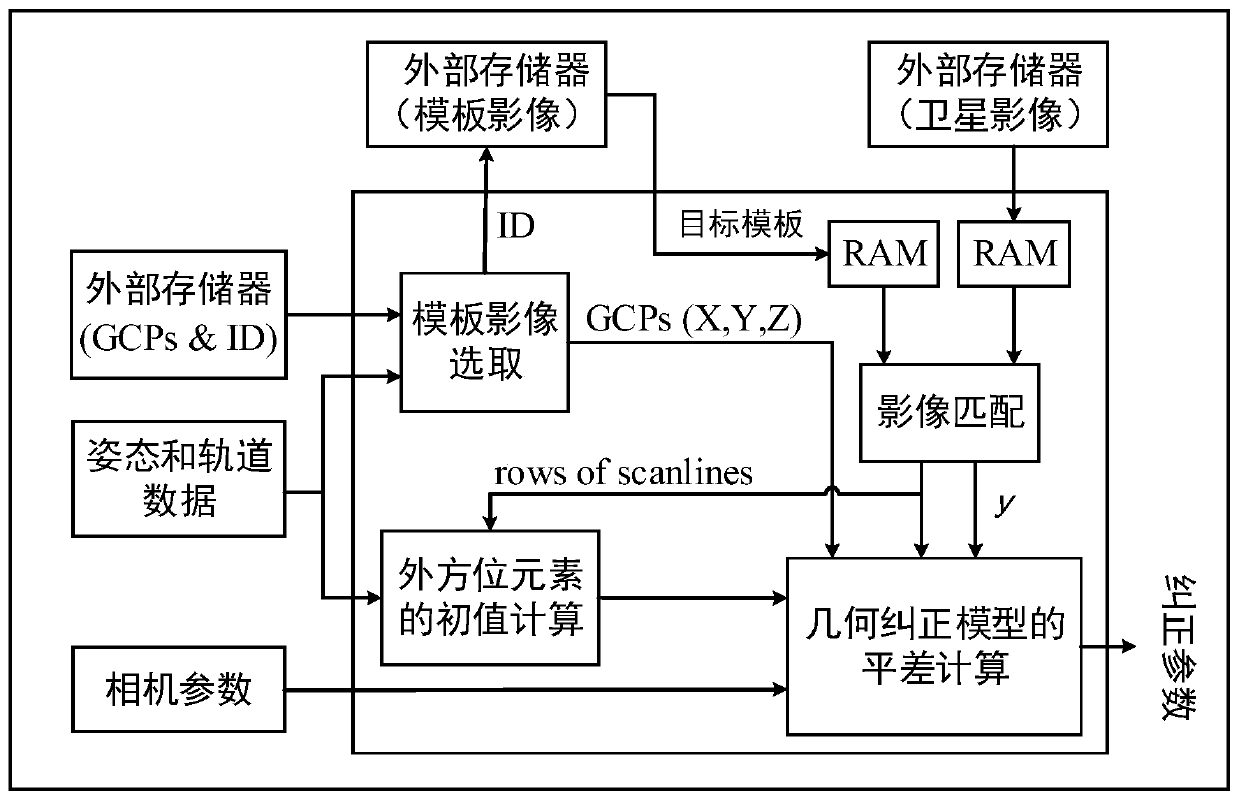
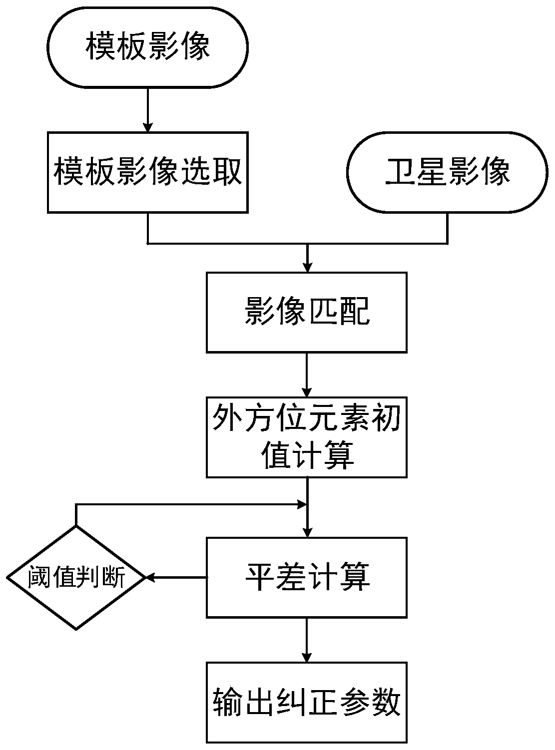
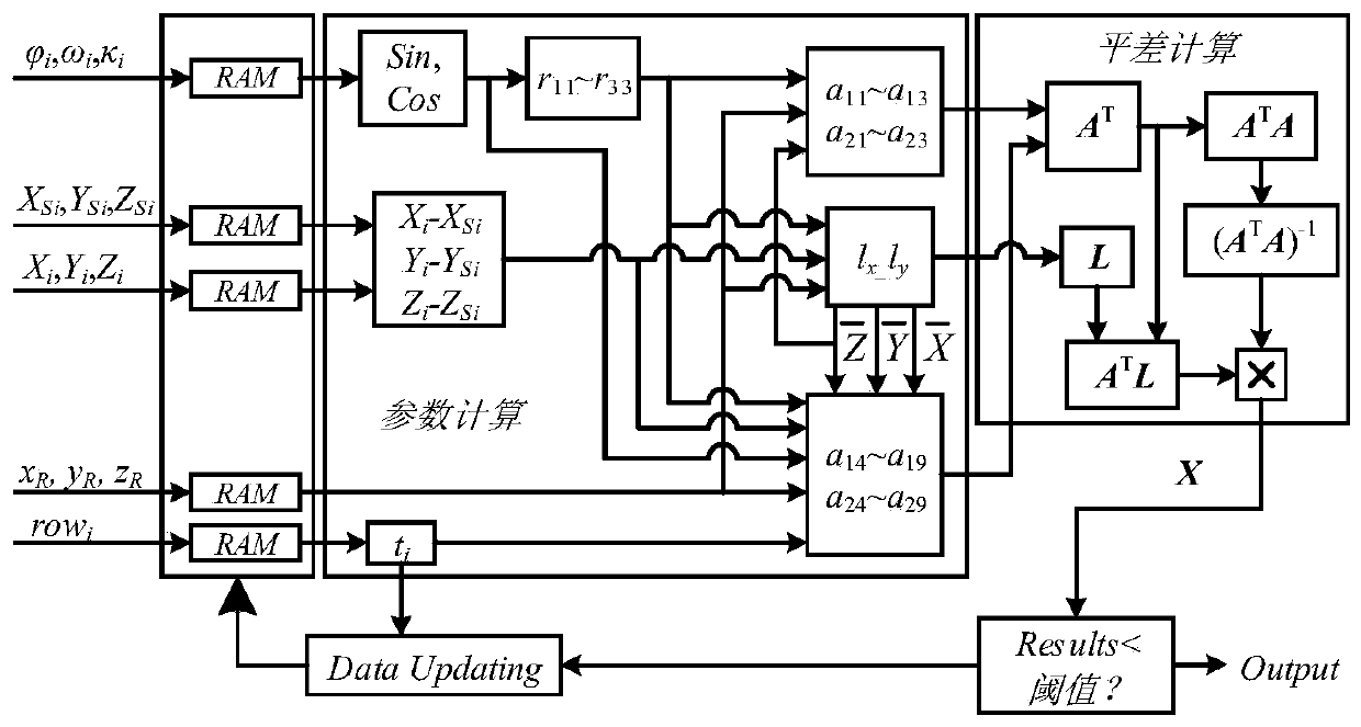
[0030] like figure 1 As shown, the present invention is mainly applied to on-board geometric correction of linear array CCD satellite images based on FPGA. Taking the three-line array CCD camera MOMS-2P as an example, its hardware is mainly divided into two parts: the initial value calculation of the outer orientation element and the calculation of the difference .

[0031] Based on the above hardware structure, such as figure 2 As shown, the realization process of the present invention is as follows:

[0032] 1. Initial Value Calculation of Outer Orientation Elements

[0033] The initial value calculation part mainly includes the template image selection module, the image matching module, and the initial value calculation module of the outer orientation element;

[0034] 1. The template image selection module calculates the approximate geodetic coordinates of the center of the ground area imaged by the satellite according to the real-time orbit and attitude measurement da...


PUM


Abstract

The invention discloses a linear array CCD satellite image on-board geometric correction method based on an FPGA. The linear array CCD satellite image on-board geometric correction method comprises the steps: (1) selecting a target template image according to comparison of approximate geodetic coordinates of an imaging area and template image control points; (2) matching the target template imagewith a satellite image, extracting image point coordinates and geodetic coordinates thereof, and transmitting orbit and attitude data of a scanning line where a control point is located to an exteriororientation element initial value calculation module; (3) performing initial value calculation by an exterior orientation element initial value calculation module, and transmitting a calculation result to a geometric correction adjustment calculation module as an initial value of adjustment calculation; (4) performing adjustment calculation to obtain correction parameters; and (5) performing threshold judgment, if the threshold is met, outputting a correction parameter, and if the threshold is not met, repeating the step (4) until the threshold is met, and outputting the correction parameter.According to the linear array CCD satellite image on-board geometric correction method, on-board geometric correction calculation can be completed accurately and quickly, and the problem of real-timeon-board geometric correction of the high-resolution linear array CCD satellite shadow is solved.

Description

technical field [0001] The invention relates to the field of remote sensing image processing, in particular to an FPGA-based on-board geometry correction method for linear array CCD satellite images. [0002] technical background [0003] As the application range of satellite remote sensing data products becomes wider and wider, the requirements for real-time data are also getting higher and higher. Completing the production of remote sensing products on the planet is a major trend in the future, such as real-time tracking and monitoring of military targets, real-time monitoring of floods, and tracking of forest fires. In satellite image preprocessing, satellite image geometry correction is one of the most important calculation steps. The geometric correction on the star directly affects whether the subsequent image processing algorithm can obtain high-precision calculation results. The traditional geometric correction method is to perform laboratory geometric correction, i...

Claims


Application Information

Patent Timeline
IPC IPC(8): G06T5/00
CPCG06T2207/10032G06T5/80Y02D10/00
Inventor 周国清宋波蒋林军
Owner GUILIN UNIVERSITY OF TECHNOLOGY
Why Eureka
Try Eureka