Mobile robot navigation map generation method based on ORB_SLAM2

A mobile robot and navigation map technology, which is applied in the field of visual SLAM and map creation, can solve the problems that the 3D environment is not well detected, cannot provide comprehensive environmental information, and the mobile robot has high real-time performance, so as to achieve real-time path planning and navigation , reduce memory size, reduce time effect

Pending Publication Date: 2019-11-26
SOUTH CHINA UNIV OF TECH +1
View PDF5 Cites 34 Cited by
  • Summary
  • Abstract
  • Description
  • Claims
  • Application Information

AI Technical Summary

Problems solved by technology

The maps created by current visual SLAM for mobile robot path planning and obstacle avoidance are usually 2D grid maps. Although 2D grid maps have a good navigation effect for mobile robots in a flat environment, they are not very good for 3D environments. Ground detection and establishment of maps cannot provide comprehensive environmental information for robots with more than three degrees of freedom such as drones
Therefore, it is of great significance to divide the three-dimensional space into 3D

Method used


Image

  • Mobile robot navigation map generation method based on ORB_SLAM2
  • Mobile robot navigation map generation method based on ORB_SLAM2
  • Mobile robot navigation map generation method based on ORB_SLAM2

Examples


Embodiment

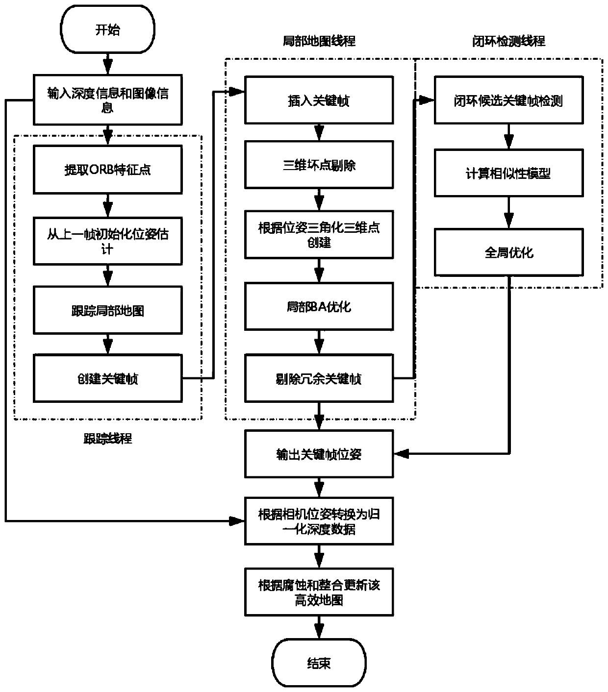
[0042] This embodiment discloses a specific implementation process of a mobile robot navigation map generation method based on ORB_SLAM2, using a ROS operating platform (Robot Operating System) to provide communication and data transmission between nodes. First start the Kinect v2 acquisition data node, and publish Kinect v2 sensor color image information and depth information messages through this node.

[0043] Subscribe to the message through the ORB_SLAM2 node, and use the ORB_SLAM2 algorithm to estimate the pose of the mobile robot. The ORB_SLAM2 algorithm uses ORB feature points to extract feature points, and uses BA optimization to optimize the pose of the mobile robot and The bag model performs loopback detection to avoid error accumulation, which is mainly divided into three threads:

[0044] 1) Tracking thread: Use ORB feature extraction to extract feature points from the collected images. If the initialization operation has not been completed and the number of featu...


PUM


Abstract

The invention discloses a mobile robot navigation map generation method based on ORB_SLAM2. The method comprises the following steps: step one, carrying out visual information collection; to be specific, enabling a mobile robot to move freely in a three-dimensional environment and collecting image information and depth information through a depth sensor; step two, on the basis of an ORB_SLAM2 algorithm, estimating pose information of the robot, carrying out local BA pose information optimization, screening key frames, selecting one key frame, outputting the pose information of the key frame, providing a sensor reference transformation matrix for creating a navigation map, and updating pose information of each key frame according to the global BA optimization under the condition of detecting a loop; and step three, carrying out map updating; to be specific, generating a three-dimensional map based on a skip list tree according to the pose information and carrying out updating continuously according to pose information of the new key frame. According to the invention, an efficient three-dimensional map is created by utilizing the depth image information; and the map uses the skip list tree structure as a data structure of the three-dimensional map, so that positioning, navigation and obstacle avoidance of the mobile robot can be realized in real time.

Description

technical field [0001] The invention relates to the technical field of visual SLAM and map creation, in particular to an ORB_SLAM2-based mobile robot navigation map generation method. Background technique [0002] Simultaneous Localization and Mapping (Simultaneous Localization and Mapping), referred to as SLAM, was first proposed by SmithSelf and Cheeseman in 1988. It is considered to be the key to realizing a truly fully autonomous mobile robot. The SLAM problem can be described as: the robot in an unknown environment Start moving from an unknown location, position itself according to position estimation and sensor data during the movement, and build an incremental map at the same time. The SLAM that only obtains environmental information through the camera is called visual SLAM. Because the camera has the characteristics of low price, low power consumption, light weight, small size, and rich image information, visual SLAM has been studied by scholars and experts at home a...

Claims


Application Information

Patent Timeline
IPC IPC(8): G01C21/32
CPCG01C21/32
Inventor 刘屿戴磊刘海明
Owner SOUTH CHINA UNIV OF TECH
Why Eureka
Try Eureka