Rapid building three-dimensional reconstruction method based on two-dimensional vector diagram and small number of elevation points

A 2D vector and 3D reconstruction technology, which is applied in photogrammetry, remote sensing, and 3D reconstruction of buildings, can solve the problems of limited 3D editing efficiency and difficult operation, and achieve the effect of improving difficulty and efficiency and making editing simple and efficient

Active Publication Date: 2019-11-29
SOUTHWEST JIAOTONG UNIV
View PDF2 Cites 2 Cited by
  • Summary
  • Abstract
  • Description
  • Claims
  • Application Information

AI Technical Summary

Problems solved by technology

[0003] In order to solve the problems of limited efficiency and difficult operation of 3D editing commonly used in the existing 3D model reconstruction process

Method used


Image

  • Rapid building three-dimensional reconstruction method based on two-dimensional vector diagram and small number of elevation points
  • Rapid building three-dimensional reconstruction method based on two-dimensional vector diagram and small number of elevation points

Examples


Embodiment

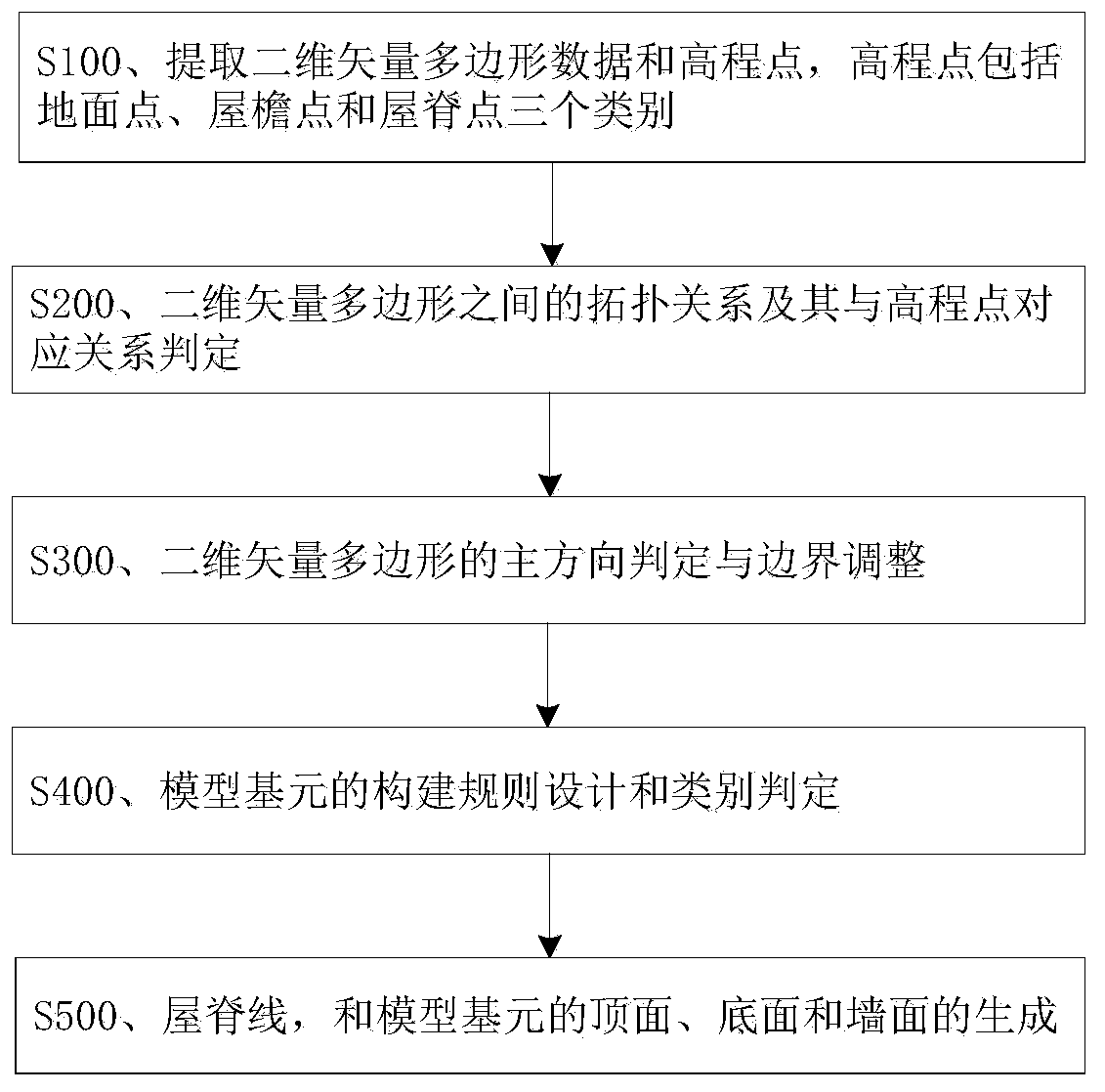
[0058] Such as figure 1 As shown, the fast building three-dimensional reconstruction method based on the two-dimensional vector diagram and a small number of elevation points of the present embodiment includes the following steps:

[0059]S100, extracting two-dimensional vector polygon data and elevation points, the elevation points include three categories of ground points, eaves points and roof ridge points;

[0060] S200, determining the topological relationship between two-dimensional vector polygons and their corresponding relationship with elevation points;

[0061] S300. Main direction determination and boundary adjustment of two-dimensional vector polygons;

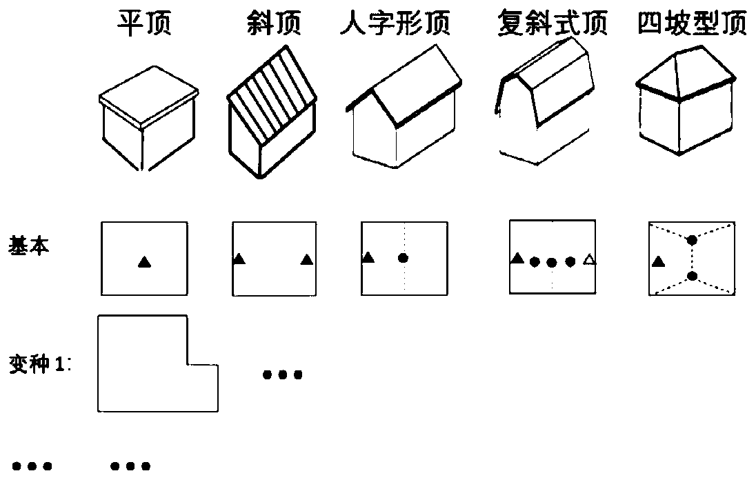
[0062] S400, design of construction rules and category determination of model primitives;

[0063] Generation of S500, ridgelines, and top, bottom, and wall faces of model primitives.

[0064] In the above step S100, the two-dimensional vector polygon data comes from surveying and mapping field, planning data, ...


PUM


Abstract

The invention discloses a quick building three-dimensional reconstruction method based on a two-dimensional vector diagram and a small number of elevation points, and the method comprises the steps: S100, extracting two-dimensional vector polygon data and the elevation points, wherein the elevation points comprise a ground point, an eave point and a ridge point; s200, judging the topological relation between the two-dimensional vector polygons and the corresponding relation between the two-dimensional vector polygons and the elevation points; s300, judging the main direction of the two-dimensional vector polygon and adjusting the boundary; s400, designing a building rule and judging a category of model elements; and S500, generating ridge lines and the top surfaces, the bottom surfaces andthe wall surfaces of the model elements. The two-dimensional vector data sources are diversified, and existing surveying and mapping field work, planning data, DOM data, DSM data, three-dimensional point cloud or grid data can be fully utilized; the difficulty and the efficiency of interactive editing are greatly improved, editing from two dimensions is simpler and more efficient than editing from three dimensions, and only a small number of elevation points need to be matched; the model is highly regularized and automatically regularized, and the generated model meets various constraints such as parallelism, verticality and the like.

Description

technical field [0001] The invention belongs to the technical field of photogrammetry, remote sensing, and three-dimensional reconstruction of buildings, and in particular relates to a fast three-dimensional reconstruction method of buildings based on two-dimensional vector graphics and a small number of elevation points. Background technique [0002] The current fully automatic 3D reconstruction methods for buildings are still difficult to meet the production needs. The semi-automatic reconstruction method is mainly based on LiDAR or multi-view image dense matching to obtain 3D point cloud or grid, and then edit and vectorize in 3D in software (such as sketchup or 3Dmax), and finally obtain a single model. The main problems are: 1. The cost of obtaining 3D point cloud or grid data is high; 2. Editing in 3D is much more difficult than 2D, and the efficiency is low; 3. Failure to reuse existing data, such as Two-dimensional planning data, DSM or DOM data. Contents of the i...

Claims


Application Information

Patent Timeline
IPC IPC(8): G06T17/10G06F17/50
CPCG06T17/10
Inventor 徐博胡翰朱庆
Owner SOUTHWEST JIAOTONG UNIV
Why Eureka
Try Eureka