Meteor trail link planning and predicting method based on GIS (Geographic Information System)

A meteor trail and prediction method technology, applied in the field of communication, can solve the problems of poor accuracy and low calculation efficiency, and achieve the effect of high accuracy, high calculation efficiency, and intuitive link analysis

Active Publication Date: 2019-12-06
NO 54 INST OF CHINA ELECTRONICS SCI & TECH GRP
View PDF5 Cites 0 Cited by
  • Summary
  • Abstract
  • Description
  • Claims
  • Application Information

AI Technical Summary

Problems solved by technology

[0004] In order to improve the poor accuracy and low calculation efficiency of the traditional meteor trail link planning method, the present invention comprehensively c

Method used


Image

  • Meteor trail link planning and predicting method based on GIS (Geographic Information System)
  • Meteor trail link planning and predicting method based on GIS (Geographic Information System)
  • Meteor trail link planning and predicting method based on GIS (Geographic Information System)

Examples


Embodiment Construction

[0034] The present invention will be described in further detail below in conjunction with the accompanying drawings and specific embodiments.

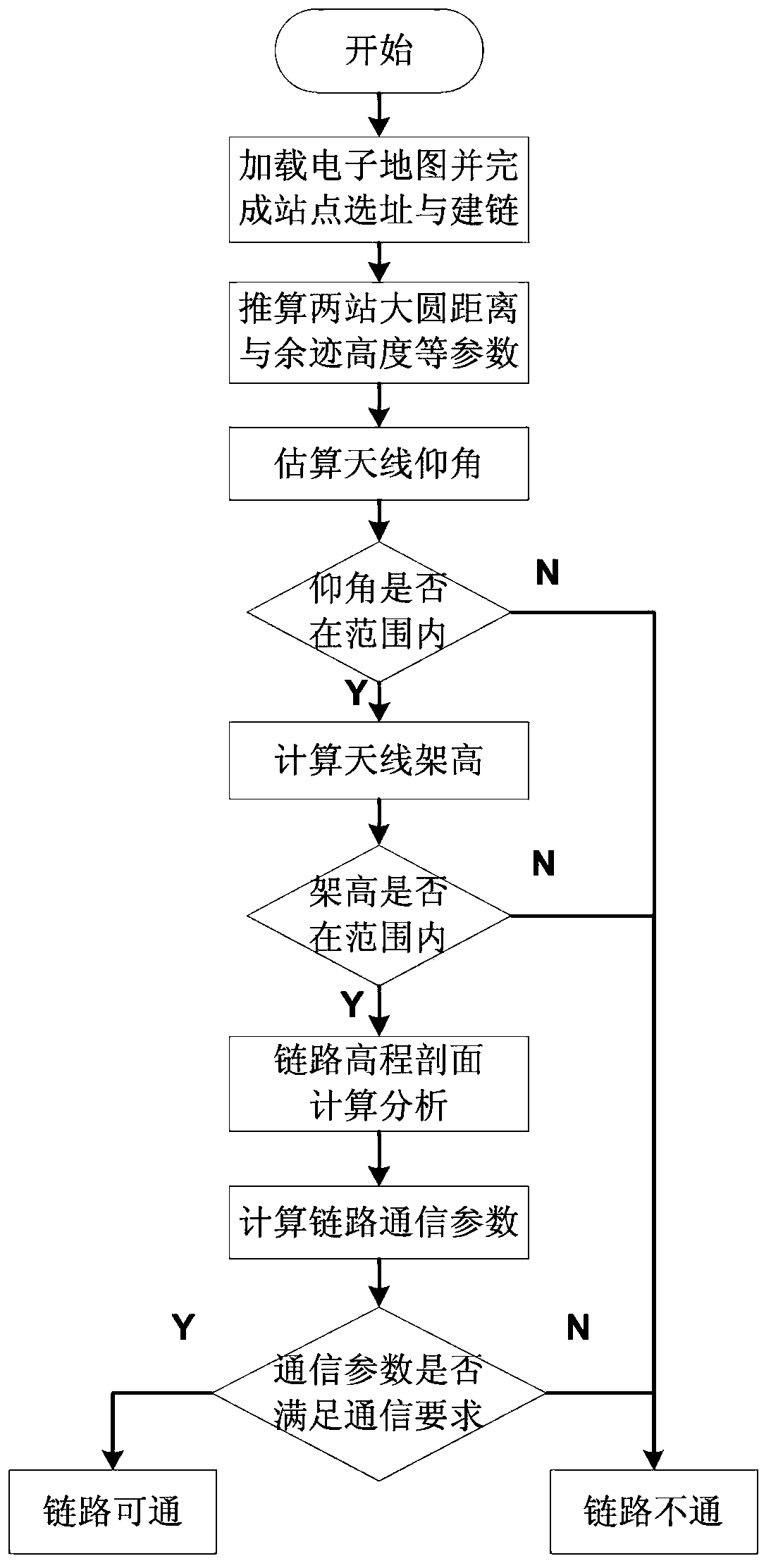
[0035] figure 1 It is a software implementation flowchart of the present invention, a method for planning and predicting meteor trail link based on GIS system, specifically comprising the following steps:

[0036] (1) After loading the electronic map, according to the geographic information data provided by the GIS system, select the sending end site and the receiving end site of the meteor trail link, and equip the sites with appropriate meteor trail communication equipment. Connect the icons of the two sites selected on the electronic map in pairs to complete the link building.

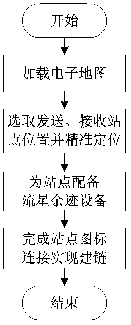
[0037] Such as figure 2 As shown, the specific process of establishing the meteor trail link includes the following steps:

[0038] (101) In the GIS system, select the specified electronic map file, open the map and load the geographic information data,...


PUM


Abstract

The invention discloses a meteoric trail link planning and predicting method based on a GIS (Geographic Information System), and belongs to the technical field of communication. A meteoric trail channel model is relatively complex in construction process, meteoric phenomena are high in regionality, a traditional meteoric trail link analysis method depends on manual prediction of on-map operation,the workload is large, the prediction efficiency is low, and the result accuracy is poor. In order to solve the above problem, we depend on a GIS platform and analyze and predict the communication quality of the planned meteor trail link in combination with specific elevation data, and the method is completely implemented by a program and is efficient, reliable and convenient. The influence of theactual terrain environment on link opening is fully considered, the meteoric trail station site selection and link planning accuracy is greatly improved, and the meteoric trail station site selectionand link planning method is particularly suitable for communication station site selection and link planning prediction in the meteoric trail communication system design stage in the complex terrainenvironment.

Description

technical field [0001] The invention belongs to the technical field of communication, and relates to a meteor trail link planning and prediction method based on a GIS (Geographic Information System) system, and is particularly suitable for communication site selection and link planning in the design stage of a meteor trail communication system in a complex terrain environment predict. Background technique [0002] Meteor trail communication is a long-distance burst communication method, which can realize reliable information transmission with a single-hop communication distance of 500-2000km within the frequency range of 30-50MHz. As an important means of minimum emergency communication, meteor trail communication is widely used in strategic emergency communication systems in the national defense and military fields, as well as emergency communication guarantees such as meteorological data collection, hydrological monitoring, and disaster reporting in the civilian field. ...

Claims


Application Information

Patent Timeline
IPC IPC(8): H04B17/373H04L12/24H04L12/26
CPCH04L41/12H04L41/145H04L41/147H04L43/0811H04B17/373
Inventor 王旭钟亚宋晓倩肖永剑于晓磊宋建明
Owner NO 54 INST OF CHINA ELECTRONICS SCI & TECH GRP
Why Eureka
Try Eureka