Method and system for detecting three-dimensional rainfall field by three-dimensional satellite-ground link dense net

A satellite-ground link and rainfall field technology, applied in the field of meteorological detection, can solve the problems of low time resolution, measurement error, and inability to meet the real-time monitoring of rainfall fields, etc.

Active Publication Date: 2020-02-07
NAT UNIV OF DEFENSE TECH
View PDF3 Cites 9 Cited by
  • Summary
  • Abstract
  • Description
  • Claims
  • Application Information

AI Technical Summary

Problems solved by technology

The former can detect the rainfall field in a large-scale continuous space, and the detection results have a high temporal and spatial resolution, but because it retrieves the rainfall intensity by detecting the water content in the air, it is difficult to accurately reflect the rainfall near the ground , when the elevation angle of the radar antenna is low, the influence of the surrounding objects will bring large errors to the measurement; the latter can detect the global rainfall field and realize the observation of the internal structure of the rainfall, but because of its It can only pass through the same area twice, resulting in low time resolution of rainfall detection, which cannot meet the requirements for continuous real-time monitoring of rainfall fields

Method used


Image

  • Method and system for detecting three-dimensional rainfall field by three-dimensional satellite-ground link dense net
  • Method and system for detecting three-dimensional rainfall field by three-dimensional satellite-ground link dense net
  • Method and system for detecting three-dimensional rainfall field by three-dimensional satellite-ground link dense net

Examples


Embodiment

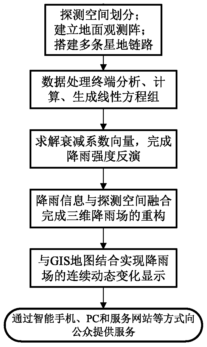
[0061] Example: figure 1 Shown is the flow chart of the embodiment of the method for detecting the three-dimensional rainfall field by the three-dimensional satellite-ground link densely woven network of the present invention, including steps:

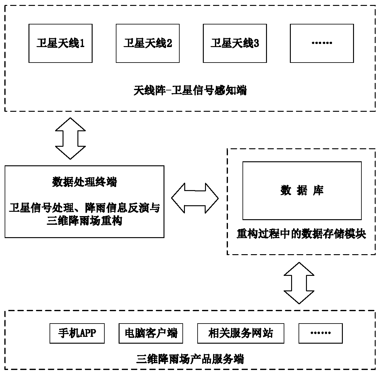
[0062] (1) Build a three-dimensional satellite-ground link densely woven network:

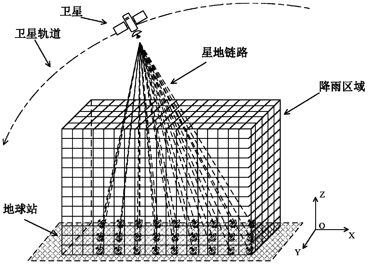
[0063] Divide the area to be detected into N×M×U identical cubes and assign markers respectively, and arrange n satellite signal receiving terminals on the ground of the area to be detected, between the n satellite signal receiving terminals and the m satellites distributed in the sky q satellite-ground links are formed between them, and the q star-ground links are interwoven to form a three-dimensional star-ground link network, such as figure 2 shown;

[0064] (2) When it rains, collect the frequency information and signal strength information of each satellite-ground link at each sampling time point t within the sampling period T, and calculate the...


PUM


Abstract

The invention provides a method and system for detecting a three-dimensional rainfall field through a three-dimensional satellite-ground link dense net. According to the method, multiple ground stations-multiple star sources are utilized to form a three-dimensional satellite-ground link dense network to detect three-dimensional rainfall field distribution: a plurality of existing or erected satellite antennas are utilized to form a ground observation network, a plurality of satellite signals are received, and a plurality of satellite-ground links form a dense three-dimensional network; the spatial distribution of attenuation coefficients is obtained by analyzing the relationship among satellite-ground link signal intensity information, rainfall attenuation coefficients and satellite-groundlink lengths, the spatial distribution of rainfall is inversed according to a relationship model of the attenuation coefficients and rainfall intensity, and the spatial distribution is combined witha GIS map to complete reconstruction, visualization and dynamic display of a three-dimensional rainfall field.Reconstruction of the three-dimensional rainfall field is completed through the satellite-ground link network, accurate, large-range and high-resolution rainfall data can be provided, and key data is provided for water resource management, agricultural development, urban inland inundationmonitoring, natural disaster early warning and the like.

Description

technical field [0001] The invention relates to the field of meteorological detection, in particular to a method and system for detecting a three-dimensional rainfall field with a three-dimensional satellite-ground link densely woven network. Background technique [0002] The detection of the three-dimensional rainfall field helps to study the formation, development and spatial distribution of rainfall, and plays an important role in water resources management and monitoring of short-term heavy rainfall. The means that can now realize three-dimensional rainfall field observation include weather radar and meteorological satellites. The former can detect the rainfall field in a large-scale continuous space, and the detection results have a high temporal and spatial resolution, but because it retrieves the rainfall intensity by detecting the water content in the air, it is difficult to accurately reflect the rainfall near the ground , when the elevation angle of the radar ante...

Claims


Application Information

Patent Timeline
Patent Type & Authority Applications(China)
IPC IPC(8): G06T17/05G06F17/12G06F16/29
CPCG06T17/05G06F17/12G06F16/29Y02A90/10
Inventor 刘西川咸明皓印敏刘磊高太长
Owner NAT UNIV OF DEFENSE TECH
Why Eureka
Try Eureka