

Overhead transmission line positioning method based on double RTK unmanned aerial vehicles
An overhead transmission line and positioning method technology, which is applied in the field of overhead transmission line positioning based on dual RTK UAVs, can solve the problem of inability to achieve sufficiently accurate pile position calibration, affect the flight safety performance of UAVs, and RTK cannot obtain fixed solutions, etc. problems, to achieve the effect of saving on-site operation time, being easy to operate in the field, and eliminating magnetic interference
- Summary
- Abstract
- Description
- Claims
- Application Information
AI Technical Summary
Problems solved by technology
Method used
Image

Examples
Embodiment Construction
[0037] Best practice:
[0038] For further describing the present invention, describe as follows with regard to design principle of the present invention:
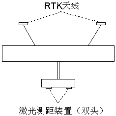
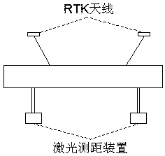
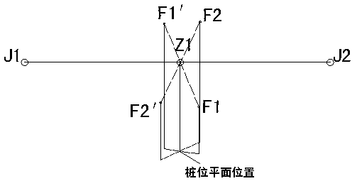
[0039] Refer to attached image 3 , when the forward direction of the dual-antenna RTK drone is J1-J2, the drone hovers over Z1, and the position of the center plane of the laser ranging is F1; when the forward direction of the drone is J2-J1, the drone hovers over Z1 , the position of the center plane of the laser ranging is F1′; in the ideal state where the UAV can maintain a horizontal attitude, the heading changes by 180 degrees, F1 and F1′ are symmetrical about Z1, that is, the horizontal positions of F1, Z1, and F1′ are collinear and Z1 is the midpoint of the straight line F1-F1′. However, due to the influence of external forces, especially wind force, and the attitude error of the drone, the drone cannot be guaranteed to be in a horizontal attitude. When the UAV is flying or hovering in the forward and reverse di...
PUM
 Abstract
Description
Claims
Application Information