GIS-based petrochemical enterprise emergency resource management and scheduling method
A technology of emergency resources and emergency materials, applied in the field of emergency resource management and scheduling of petrochemical enterprises, can solve the problems of low emergency scheduling efficiency, insufficient combination of emergency resource management and scheduling with spatial geographic location information, etc.
- Summary
- Abstract
- Description
- Claims
- Application Information
AI Technical Summary
Problems solved by technology
Method used
Image

Examples
Embodiment 1
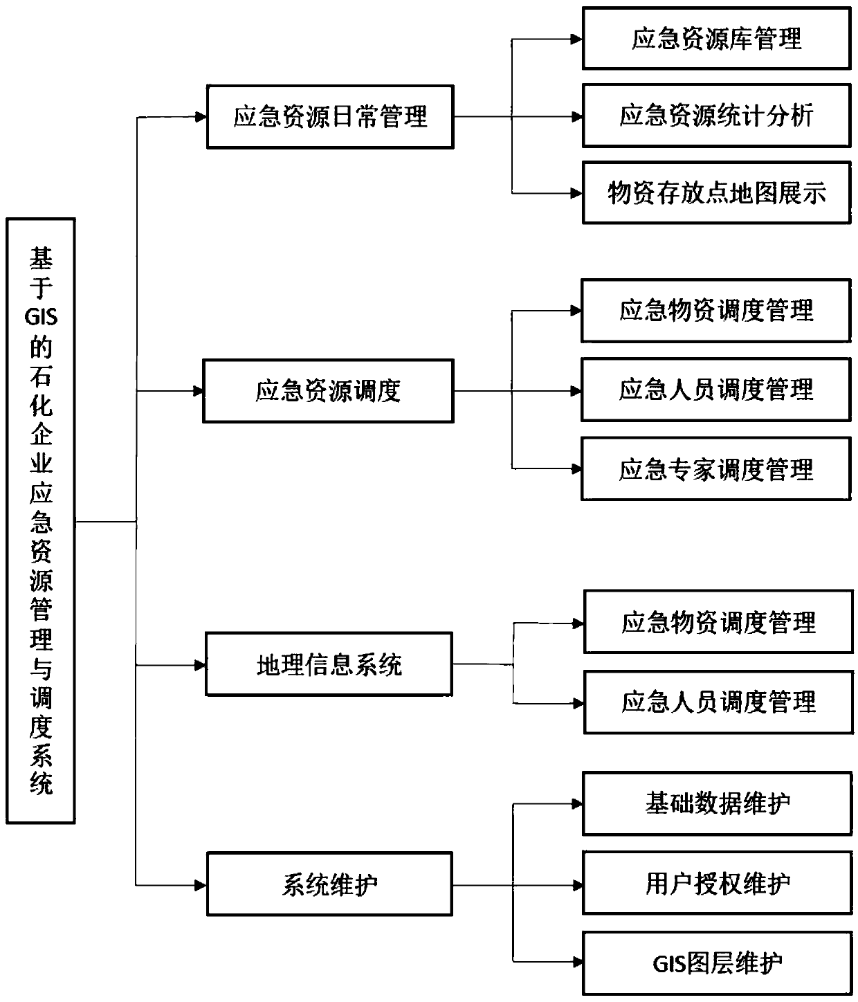
[0039] This patent is based on GIS technology, on the basis of independent research and development, combined with existing communication, network, software, and hardware, to create a GIS-based emergency resource management and dispatching system. System structure such as figure 1 shown.
[0040] (1) Construct and improve the construction of the basic database (petrochemical enterprises), collect emergency monitoring equipment, emergency rescue facilities, emergency communication equipment, emergency protection equipment, medical rescue facilities, emergency vehicles, emergency rescue teams (firefighting, gas defense, Hospitals, emergency repairs, etc.), emergency expert information, surrounding environment (residential areas, water sources, etc.) scheduling management;
[0041] (2) Improve the construction of GIS professional layers based on existing Baidu map, Gaode map and other services or Esri's ArcGIS professional map service;
[0042] (3) Relevant personnel can reali...
Embodiment 2
[0045] Taking the emergency rescue process of a leakage accident in a petrochemical enterprise as an example to illustrate the implementation process of emergency resource scheduling in this patent.
[0046] (1) After the incident, the accident emergency management personnel log in to the emergency resource management and dispatching system using a PC or smart mobile terminal that can be connected to the Internet; through the "accident location" button, locate the accident location on the pop-up GIS page, Select the number of materials, personnel, experts, teams and other resources called for this accident on the page, and the emergency resource database will also change in real time at this time.
[0047] (2) When the dispatch of emergency resources begins, the GIS map page will display the real-time location information of the current main resources in real time according to the dispatch results, including the current location of emergency vehicles, emergency supplies, and em...
Embodiment 3
[0051] A GIS-based emergency resource management method and system for petrochemical enterprises is provided, which mainly includes a daily emergency resource management module, an emergency resource scheduling module under sudden accidents, a geographic information system module, and a system maintenance module.
[0052] 1Emergency resources daily management module
[0053] Unified management of emergency monitoring equipment, emergency rescue facilities, emergency communication equipment, emergency protective equipment, medical rescue facilities, emergency vehicles and other information. Realize the statistics and analysis of emergency material information, including the basic information, types, quantities, usage methods, storage locations, current status (idle, in use) of emergency resources and their units, historical scheduling cases and other information. Relevant personnel can perform operations such as query, addition, deletion, and modification through PCs or smart m...
PUM
 Abstract
Description
Claims
Application Information