Method, device and equipment for determining terrain complexity of point location of wind generating set

A technology of wind turbines and complexity, applied in computer-aided design, electrical digital data processing, design optimization/simulation, etc., can solve problems such as site selection in the early stage of wind farm construction

Pending Publication Date: 2020-03-27
BEIJING GOLDWIND SCI & CREATION WINDPOWER EQUIP CO LTD
View PDF5 Cites 6 Cited by
  • Summary
  • Abstract
  • Description
  • Claims
  • Application Information

AI Technical Summary

Problems solved by technology

[0003] At present, most of the research on terrain complexity is determined by judging the elevation difference and elevation change rate within a certain area. This kind of terrain complexity research only describes a single feature of terrain complexity, and does not combine wind farms and wind turbines. Considering the relationship between wind direction, topography and topography in the special situation of the distribution, it is not suitable for the site selection in the early stage of wind farm construction.

Method used


Image

  • Method, device and equipment for determining terrain complexity of point location of wind generating set
  • Method, device and equipment for determining terrain complexity of point location of wind generating set
  • Method, device and equipment for determining terrain complexity of point location of wind generating set

Examples


Embodiment 1

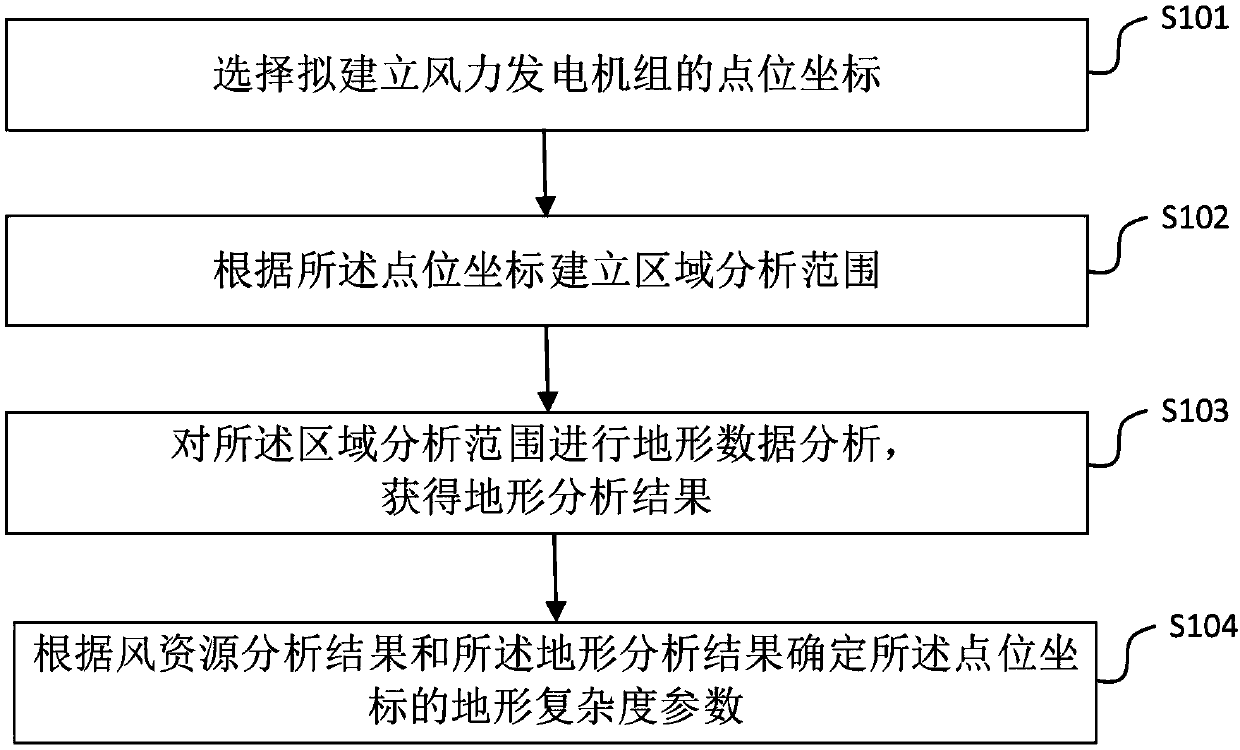
[0069] In order to solve the problems and defects existing in the prior art, the following in conjunction with the attached figure 1 The main flow of the method for determining the topographical complexity of a wind power generation unit location according to Embodiment 1 of the present invention is specifically introduced. The method mainly includes the following steps:

[0070] S101, selecting the point coordinates of the wind power generating set to be established;

[0071] Specifically, first select the point where the wind power generating set is to be built. A point is selected in a map with a coordinate system established. Specifically, the point coordinates can be two-dimensional or three-dimensional map coordinates, so as to obtain an accurate position representation of the point. Specifically, for point coordinates, an X value and a Y value with the same precision can be selected for representation. In order to facilitate subsequent calculations, it is also necess...

Embodiment 2

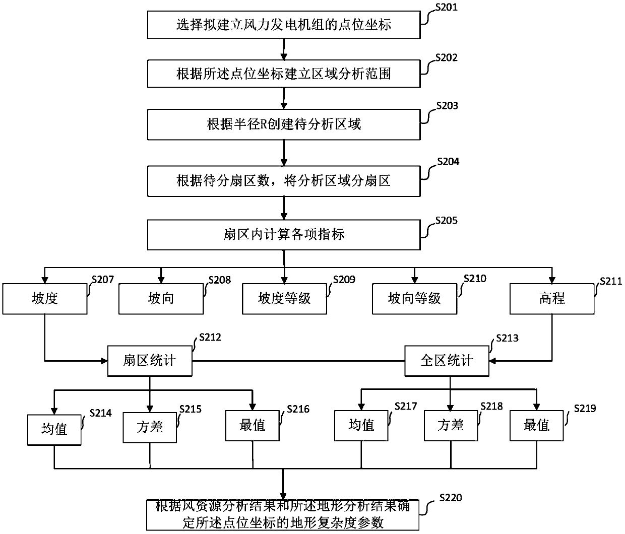
[0081] Attached below figure 2 The main flow of the method for determining the topographical complexity of the location of the wind power generation unit according to the embodiment of the present invention is further introduced.

[0082] S201, selecting the point coordinates of the wind power generation unit to be established;

[0083] Specifically, according to the existing topography of the wind farm, coordinates of the pre-established wind power generators can be drawn up, and the coordinates can be configured to establish a relevant data analysis mode and related accuracy for subsequent calculation preparation. For example, to facilitate calculation, it can be a coordinate representation in the form of double. Specifically, an existing coordinate system can be used to transform it into a coordinate system that is convenient for calculation, for example, the UTM (Universal Transverse Mercator, Universal Transverse Mercator) coordinate system is a kind of planar rectangul...

Embodiment 3

[0131] Figure 4 It is a schematic diagram of the module structure of the device for determining the topographical complexity of a wind power generation unit location according to an embodiment of the present invention.

[0132] The device for determining the topographical complexity of a wind power generation unit in an embodiment of the present invention includes four functional modules, which are a point coordinate selection unit 401, an area analysis range establishment unit 402, an area analysis range analysis unit 403, and point coordinate evaluation Unit 404. in,

[0133] The point coordinate selection unit 401 is used to select the point coordinates of the wind power generating set to be built.

[0134] An area analysis range establishing unit 402, configured to establish an area analysis range according to the point coordinates.

[0135] The area analysis range analysis unit 403 is configured to perform data analysis on the area analysis range to obtain topographic...


PUM


Abstract

The invention provides a method, a device and equipment for determining the terrain complexity of a point location of a wind generating set. The determination method comprises the following steps: selecting point position coordinates of a wind generating set to be established; establishing a region analysis range according to the point position coordinates; performing topographic data analysis onthe regional analysis range to obtain a topographic analysis result; and determining terrain complexity parameters of the point position coordinates according to a wind resource analysis result and the terrain analysis result. The method for determining the terrain complexity of point locations of the wind generating set is suitable for a regional characterization mode of wind power plant terrainanalysis, analyzes and describes the complexity of terrain or point locations according to the region, can better adapt to the conditions of wind power plant construction and early-stage theoretical analysis, and can quickly, efficiently and accurately judge whether wind generating sets are established for point location coordinates or not in combination with a wind resource analysis result.

Description

technical field [0001] The present invention relates to the technical field of wind power generation, in particular, the present invention relates to a method, device and equipment for determining the topographical complexity of a wind power generating set point. Background technique [0002] The wind power industry needs to model and simulate the geographical environment of the study area when conducting macro- and micro-site selection of wind farms. Terrain and landform data are important data inputs for modeling, and their accuracy greatly affects the final results. evaluation accuracy. In the pre-planning process of wind farms, it is necessary to estimate the terrain complexity of the wind farm area to determine the difficulty of later construction or the location of wind turbines. [0003] At present, most of the research on terrain complexity is determined by judging the elevation difference and elevation change rate within a certain area. This kind of terrain complex...

Claims


Application Information

Patent Timeline
Patent Type & Authority Applications(China)
IPC IPC(8): G06F30/20G06F113/06
Inventor 孙红磊姜云鹏杜康举
Owner BEIJING GOLDWIND SCI & CREATION WINDPOWER EQUIP CO LTD
Why Eureka
Try Eureka