Beryllium-10 isotope-based data-free watershed soil erosion degree evaluation method

A soil erosion and isotope technology, which is applied in the analysis of materials, material analysis by electromagnetic means, and measurement devices, can solve the problems of research coverage area and precision limitation, and there is no method for soil erosion, and achieve good reproducibility of results , high operating efficiency and strong transplantability

Active Publication Date: 2020-04-07
HOHAI UNIV
View PDF1 Cites 0 Cited by
  • Summary
  • Abstract
  • Description
  • Claims
  • Application Information

AI Technical Summary

Problems solved by technology

For areas with detailed hydrometeorological observation data, the soil erosion dynamics of the corresponding watershed in recent decades can be obtained through direct observation or model simulation; but for watersheds without data, the soil er

Method used


Image

  • Beryllium-10 isotope-based data-free watershed soil erosion degree evaluation method
  • Beryllium-10 isotope-based data-free watershed soil erosion degree evaluation method
  • Beryllium-10 isotope-based data-free watershed soil erosion degree evaluation method

Examples


Example Embodiment

[0018] Embodiment one:

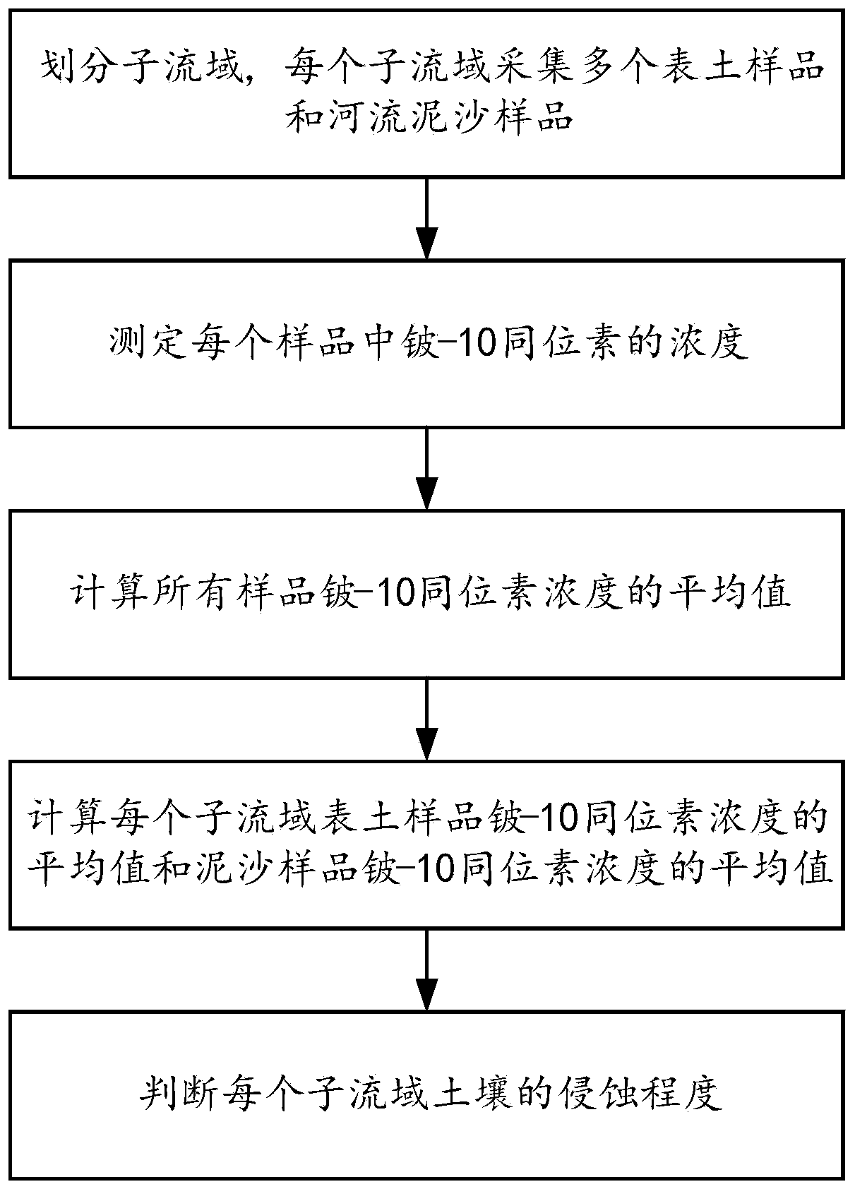
[0019] like figure 1 As shown, the present invention discloses a method for evaluating the degree of soil erosion in a watershed without data based on beryllium-10 isotope, comprising the following steps:

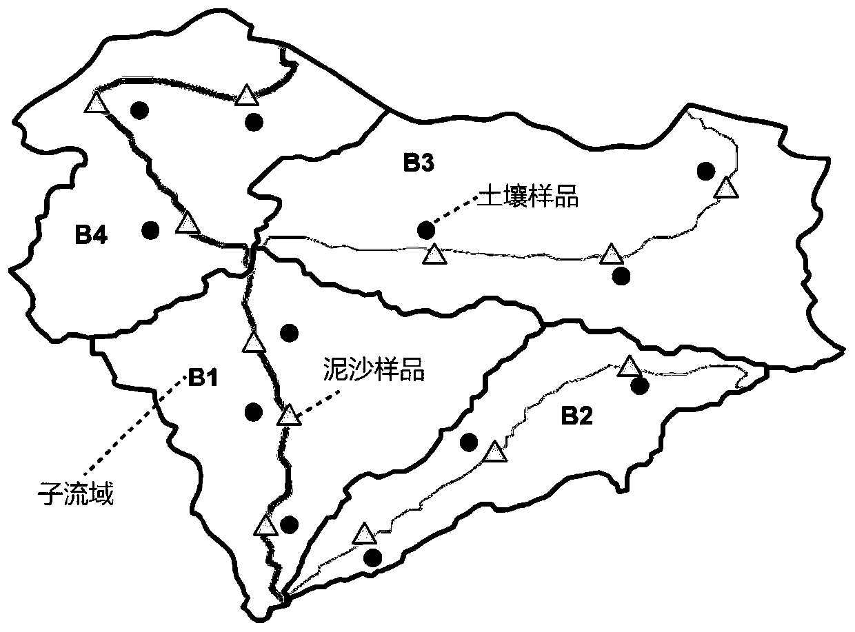
[0020] Step 1. Divide the data-free watershed to be assessed into multiple sub-basins, and collect multiple topsoil samples and multiple river sediment samples in each sub-basin;

[0021] In this example, a watershed without data in the source area of ​​the Yellow River is taken as the research area. First, the watershed is divided into multiple sub-basins by using ArcSWAT software, such as figure 2 For the four sub-watersheds B1, B2, B3, and B4 shown, 3 samples of topsoil at a depth of 0-50 cm were collected in each sub-basin, and 3 samples of river sediment at a depth of 10 cm on the bottom surface of the river water body were collected and packed in ziplock bags.

[0022] Step 2, measure the concentration of beryllium-10 isotope in each sample...

Example Embodiment

[0034] Embodiment two:

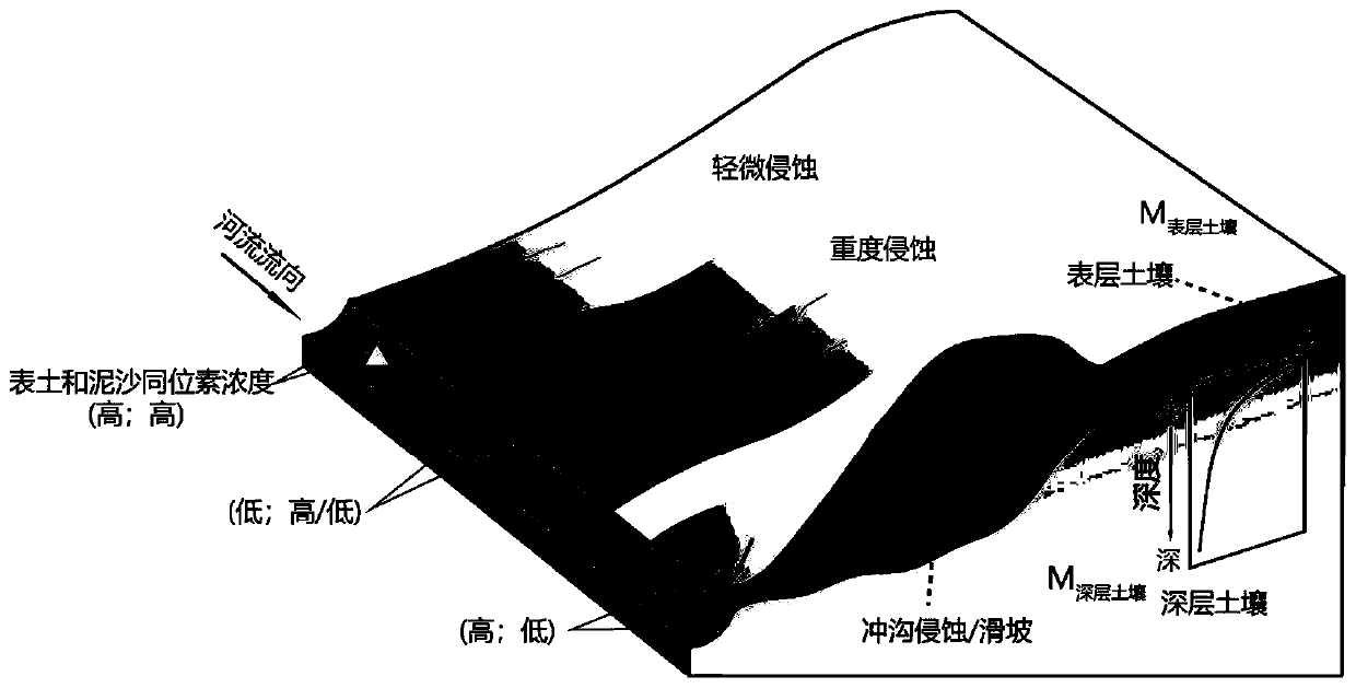
[0035] On the basis of Embodiment 1, this embodiment discloses a method for calculating the erosion ratio of different soil layers, including:

[0036] Step A. Establish erosion and isotope conservation models of different soil layers:

[0037] Among them: C 土壤 is the average value of the beryllium-10 isotope concentration of topsoil samples in the sub-watershed, unit: atoms / g; C 深层土壤 is the concentration value of beryllium-10 isotope in the deep soil in the sub-watershed, because the concentration is extremely low, the value is 0; C 泥沙 is the average value of beryllium-10 isotope concentration of river sediment samples in the sub-watershed. Unit: atoms / g; M 表土 is the surface soil erosion percentage of the sub-basin, unit: %; M 深层土壤 is the percentage of deep soil erosion in the sub-basin, unit: %; M 表土 +M 深层土壤 is the total amount of erosion, that is, 100%. The schematic diagram of the model is as image 3 shown.

[0038] Step B, the result o...


PUM

PropertyMeasurementUnit
Depthaaaaaaaaaa

Abstract

The invention discloses a beryllium-10 isotope-based data-free watershed soil erosion degree evaluation method, which comprises the steps of 1, dividing a to-be-evaluated data-free watershed into a plurality of sub-watersheds, and collecting a plurality of surface soil samples and a plurality of river sediment samples in each sub-watershed; 2, measuring the concentration of beryllium-10 isotope ineach sample; 3, calculating the average value C average of beryllium-10 isotope concentrations of all samples; 4, calculating an average value of beryllium-10 isotope concentration of the surface soil sample of each sub-basin and an average value of beryllium-10 isotope concentration of the sediment sample of each sub-basin, wherein at the moment, the sub-basin i is severe erosion; and if so, thesub-watershed i has a landslide or is eroded by a gully. The method can be used for scientifically evaluating the soil erosion degree of the non-data drainage basin.

Description

technical field [0001] The invention relates to a method for evaluating soil erosion degree of an undatad watershed based on beryllium-10 isotope, and belongs to the technical field of soil dynamic monitoring. Background technique [0002] Beryllium-10 isotopes are produced by nuclear fission of nitrogen and oxygen atoms in the atmosphere under the bombardment of cosmic ray particles. To the troposphere, it mainly settles to the surface through rainfall, and then is tightly adsorbed in the soil particles. It is stable in nature, not easy to dissolve, and moves with the migration of soil particles. Because the clay particles in the surface soil provide a larger surface area and absorb more beryllium-10 isotope, the concentration of beryllium-10 isotope in the surface soil is higher, and the isotope concentration decreases sharply with the increase of soil depth. Therefore, the beryllium-10 isotope concentration in soil can be directly measured and used as the main indicator ...

Claims


Application Information

Patent Timeline
IPC IPC(8): G01N27/62
CPCG01N27/62
Inventor 陈鹏徐慧敏衣鹏王锦国
Owner HOHAI UNIV
Why Eureka
Try Eureka