Quick updating method for glacier inventories

An update method, glacier technology, applied in the direction of image data processing, instrumentation, 2D image generation, etc., can solve the problems of poor extraction effect, difficulty in accurately distinguishing surface moraine boundaries, etc., and achieve the effect of improving extraction accuracy

Active Publication Date: 2020-04-10
ANHUI UNIV OF SCI & TECH
View PDF3 Cites 2 Cited by
  • Summary
  • Abstract
  • Description
  • Claims
  • Application Information

AI Technical Summary

Problems solved by technology

Since the surface moraine of a glacier has the same spectral and texture characteristics as its surrounding bare rock, automatic classification

Method used


Image

  • Quick updating method for glacier inventories
  • Quick updating method for glacier inventories
  • Quick updating method for glacier inventories

Examples


Embodiment 1

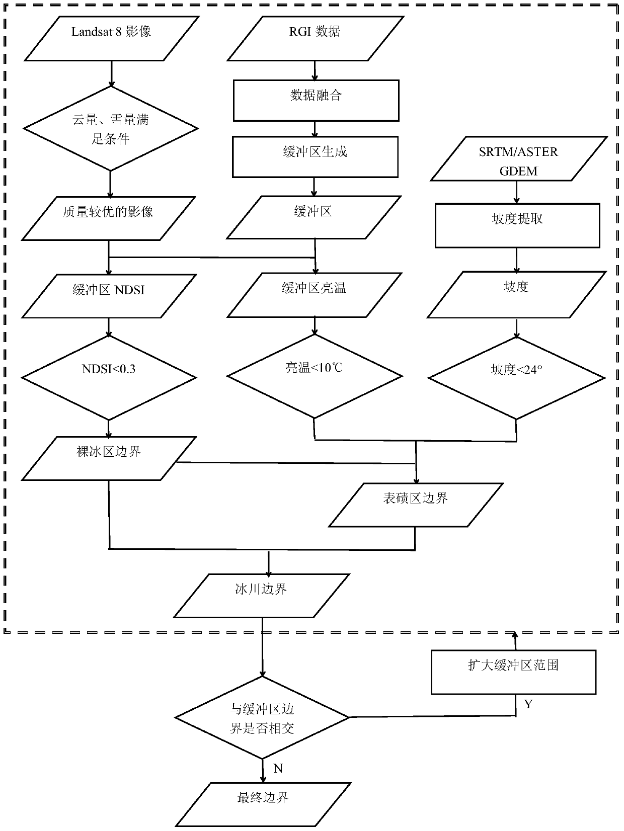
[0052] RGI collected the data of the second glacier catalog in China, and extracted the bare ice area by taking Malanshan Glacier, Sun Lake Glacier and some glaciers around them as examples. figure 1 is a technical flow chart of the present invention, figure 2 It is the Landsat 8 image (LC08_139035_20130731) used to extract the bare ice area, the row number is 35 / 139, the cloud cover is 0.18%, and the imaging time is July 31, 2013, as figure 1 "Better image quality" in .

[0053] Specifically, the steps of the method provided by the invention are as follows:

[0054] (1) Call the Landsat 8 image directly in GEE and perform cloud removal processing on it;

[0055] (2) Based on the preprocessed image, calculate NDSI and set the threshold to 0.3, where the third and sixth bands of the Landsat8 image correspond to the green band and shortwave infrared band in formula (1) respectively;

[0056] (3) In the ArcGIS software, the required RGI data is fused, uploaded to GEE, and a b...

Embodiment 2

[0059] Taking the glacier encoded as Kekesay Glacier and G075207E38269N in the RGI data as an example, the surface moraine area was extracted. Figure 4 It is the Landsat 8 image (LC08_149033_20150711) used to extract the surface moraine area, the row number is 33 / 149, the cloud cover is 1.96%, and the imaging time is July 11, 2015, as figure 1 "Better image quality" in .

[0060] Specifically, the steps of the method provided by the invention are as follows:

[0061] (1) Extracting the boundary of the bare ice area is similar to that in Example 1.

[0062] (2) Call SRTM directly in GEE to calculate the slope of the glacier, extract the boundary of the bare ice area under the condition that the brightness temperature is less than 10°C and the slope is less than 24°, obtain the preliminary boundary of the moraine area, and judge the boundary of the buffer zone and the surface Whether the boundary of the moraine area intersects, and if it intersects, expand the scope of the bu...

Embodiment 3

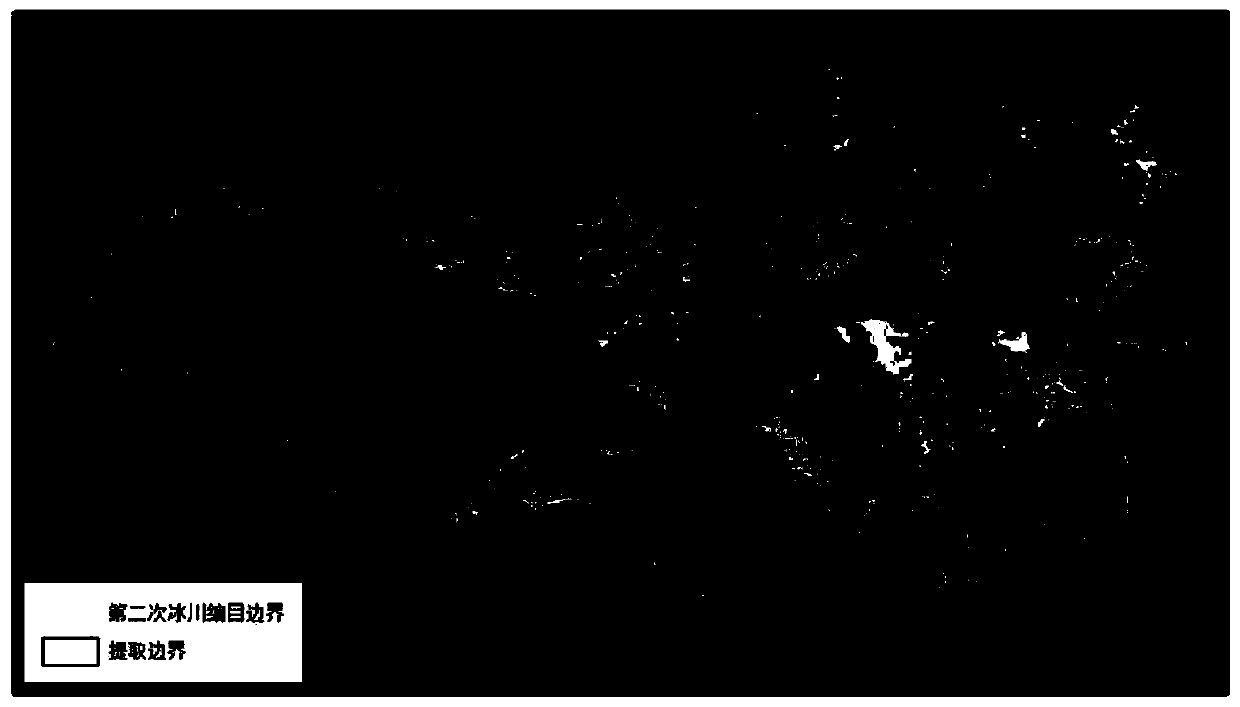
[0064] Taking Monomaha Glacier, North Monomaha Glacier, Zu Glacier and some glaciers around them as examples in the RGI data, the advancing glaciers are extracted. figure 2 It is the Landsat 8 image (LC08_139035_20130731) used to extract the advancing glacier, the row number is 35 / 139, the cloud cover is 0.18%, and the imaging time is July 31, 2013, as figure 1 "Better image quality" in .

[0065] Specifically, the steps of the method provided by the invention are as follows:

[0066] (1) Extracting the boundary of the bare ice area and the boundary of the surface moraine area is similar to embodiment 1 and embodiment 2;

[0067] (2) The boundary of the bare ice area extracted in (1) intersects the boundary of the buffer zone, and the glacier is an advancing glacier, Figure 6 For the final advancing glacier boundary.


PUM


Abstract

The invention discloses a quick updating method for glacier inventories. The method comprises the following steps: with a Landsat image having relatively high quality as a basis, calculating a normalized snow cover index in GEE; setting the threshold value of NDSI to be 0.3, fusing the required Randolph glacier inventory (RGI), generating a buffer area outwards by taking 100 m as a radius, and superposing the buffer area with the NDSI to obtain the boundary of the bare ice area of a glacier; inverting brightness temperature based on the thermal infrared band of Landsat 8, calculating a gradient based on SRTM or ASTER GDEM, and extracting a superglacial moraine area under the conditions that the brightness temperature is less than 10 DEG C and the gradient is less than 24 DEGs to obtain theboundary of the superglacial moraine area; and judging whether the boundary of the buffer area is intersected with the boundary of the glacier or not, and if so, expanding the range of the buffer area until the buffer area boundary is not intersected with the glacier boundary, thereby acquiring the final glacier boundary. According to the quick updating method for glacier inventories, the GEE serves as a platform, the glacier is divided into the bare ice area and the superglacial moraine area for extraction, the advancing glacier is recognized by setting the buffer area with a certain distance, and a large-range glacier inventory is rapidly and accurately updated.

Description

technical field [0001] The invention relates to the field of glacier catalogs, in particular to a method for quickly updating glacier catalogs. Background technique [0002] Glaciers are very important solid water resources that provide supplies to downstream rivers and are "indicators" of climate change. Therefore, monitoring changes in glacier boundaries is crucial to the production and life of human society. At present, the main methods can be divided into two types: manual visual interpretation and computer automatic classification. Manual visual interpretation has high accuracy and is relatively simple, but it takes a long time and may misjudge glacier areas due to personal subjective factors. Computer automatic classification mainly uses the strong absorption of short-wave infrared band and strong reflection of visible light to near-infrared band by ice and snow, mainly including supervised classification, unsupervised classification, band ratio method and normalized ...

Claims


Application Information

Patent Timeline
IPC IPC(8): G06T11/00
CPCG06T11/001Y02A90/10
Inventor 张震胡克宏
Owner ANHUI UNIV OF SCI & TECH
Why Eureka
Try Eureka