BIM-based geotechnical engineering comprehensive investigation information interpretation method and system

A technology of geotechnical engineering and interpretation, applied in image data processing, 3D modeling, instruments, etc., can solve the problems of lack of access to geophysical data, poor versatility of 3D interpretation results, and can not be universally used to improve computing efficiency, Effects that facilitate human intervention and editing, and improve believability

Active Publication Date: 2020-04-28
SHANDONG TRAFFIC PLANNING DESIGN INST
View PDF9 Cites 9 Cited by
  • Summary
  • Abstract
  • Description
  • Claims
  • Application Information

AI Technical Summary

Problems solved by technology

[0004] The inventors found that the existing three-dimensional interpretation of geotechnical engineering comprehensive survey results mainly has the following problems: (1) At present, there is no method and application for three-dimensional interpretation of comprehensive survey results through BIM software development; (2) The drilling and geophysical results application software used in the survey work is relatively independent, and the development enviro

Method used


Image

  • BIM-based geotechnical engineering comprehensive investigation information interpretation method and system
  • BIM-based geotechnical engineering comprehensive investigation information interpretation method and system
  • BIM-based geotechnical engineering comprehensive investigation information interpretation method and system

Examples


Embodiment 1

[0047] Attached below Figure 2-Figure 11 The present invention will be described in detail. Specifically, the structure is as follows:

[0048] This embodiment provides a BIM-based geotechnical engineering comprehensive survey information interpretation method, including the following steps:

[0049] (1) Establish a unified project database and store data:

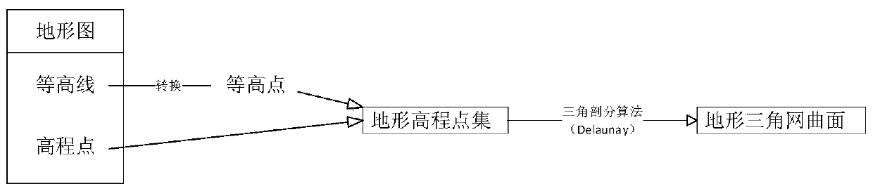
[0050] First, obtain data from survey drilling and drilling holes, high-density electrical and seismic wave data for geophysical exploration, and field geological survey data.

[0051] Establish a survey project information table based on the engineering survey project, including the engineering survey unit, person in charge, participants, start time, survey stage, site ID and name list, project strata summary table, geological time representative and other information.

[0052] Drilling hole data includes the site ID, drill hole ID and name, basic work information of the survey hole, position information, drill hole formation inf...

Embodiment 2

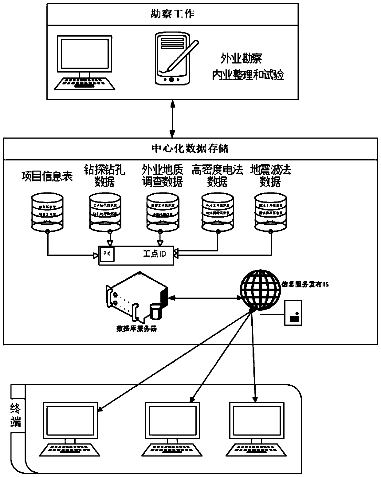
[0068] This embodiment provides a BIM-based comprehensive geotechnical engineering survey information interpretation system, such as figure 1 Shown, including:

[0069] The data storage module is used to store data, where the data includes project information tables, drilling borehole data, field geological survey data, high-density electrical method data, and seismic wave method data.

[0070] Data extraction module, used to import terrain CAD data.

[0071] The interpretation module is used to automatically interpret the data to obtain interpretation information.

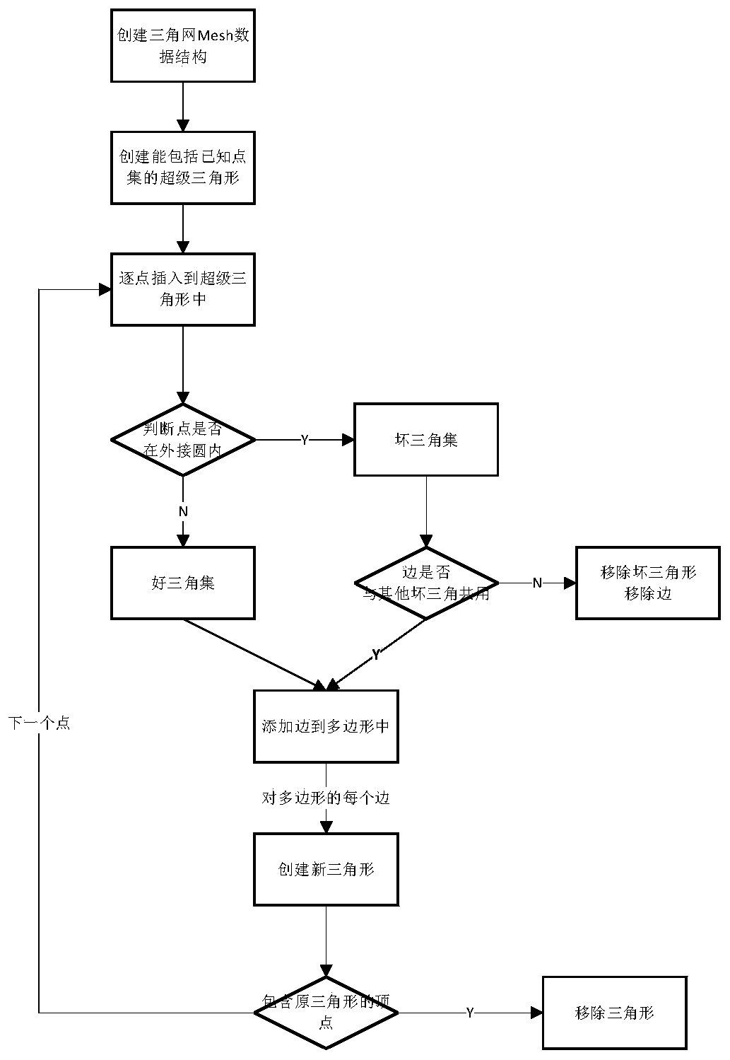
[0072] The geological body building module is used to establish a comprehensive model of survey results according to the interpretation information, perform weight assignment and three-dimensional geological surface interpolation fitting; establish a geological body according to the topographic surface, and perform a Boolean operation on the geological surface to obtain a layered and divided geological body.


PUM


Abstract

The invention discloses a BIM-based geotechnical engineering comprehensive investigation information interpretation method, which realizes three-dimensional interpretation of comprehensive investigation results based on a BIM technology and performs three-dimensional visual integration on the investigation results. According to the technical scheme, the method comprises the steps of establishing aunified project database, and storing data; calling in terrain CAD data; carrying out automatic interpretation on the data to obtain interpretation information; carrying out three-dimensional interpretation on the field geological survey data; performing three-dimensional interpretation according to the high-density electrical survey lines, and establishing interval stratum segmented three-dimensional interpretation multi-line segments; setting a reflection coefficient value according to a seismic wave method, and establishing an inversion three-dimensional contour surface; reading drilling data, and establishing a three-dimensional drilling model according to stratum attributes; establishing an investigation result comprehensive model according to the interpretation information, and carrying out weight assignment and three-dimensional geological curved surface interpolation fitting; and establishing a geologic body according to the topographic surface, and performing Boolean operation on the geologic curved surface to obtain a layered and blocked geologic body.

Description

Technical field [0001] The present invention relates to the field of BIM technology, in particular to a BIM-based method and system for interpretation of comprehensive geotechnical engineering survey information. Background technique [0002] At present, BIM technology has been widely used and promoted in many industries of engineering infrastructure construction. Various CAD software and three-dimensional modeling software have carried out many attempts in the fields of architecture, structure, highway and railway bridges, water conservancy facilities, and provided a variety of modeling methods. However, the current BIM applications are mostly BIM modeling applications for structures to be constructed, and there is a lack of systematic BIM modeling methods for existing geological bodies. The BIM applications for survey results focus on a single analysis of drilling or geophysical results, with different data formats , Information interaction is not smooth, and there is no three...

Claims


Application Information

Patent Timeline
IPC IPC(8): G06F30/13G06F30/12G06T17/00
CPCG06T17/00Y02A90/10
Inventor 赵杰徐润马文琪林波林志军张鑫王超柳尚钟国强宋杰
Owner SHANDONG TRAFFIC PLANNING DESIGN INST
Why Eureka
Try Eureka