Three-dimensional real-time map construction method and device

A map construction and three-dimensional technology, applied in the field of data processing, can solve the problems of high computing power requirements, waste of resources, information processing efficiency, lack of effective information extraction and feature identification, etc., to achieve small amount of information transmission data and large amount of effective information Effect

Active Publication Date: 2020-05-05
AVIC HUADONG PHOTOELECTRIC SHENZHEN CO LTD
View PDF8 Cites 0 Cited by
  • Summary
  • Abstract
  • Description
  • Claims
  • Application Information

AI Technical Summary

Problems solved by technology

[0003] In order to provide a more intuitive battlefield situation awareness for command and decision-making, it is necessary to construct a three-dimensional intelligible enhanced digital map in real time. Aircraft or drones will send high-definition pictures or processed three-dimensional enhanced maps to the headquarters. With the development of network communication technology, it is impossible to transmit high-definition images remotely in real time; and real-time image processing terminals have high requirements on the computing power of graphics processing chips; most of the content in images is invalid information for users, and there is a lack of effective information extraction and features Identification, there are problems such as waste of resources and low efficiency of information processing

Method used


Image

  • Three-dimensional real-time map construction method and device
  • Three-dimensional real-time map construction method and device
  • Three-dimensional real-time map construction method and device

Examples


Embodiment Construction

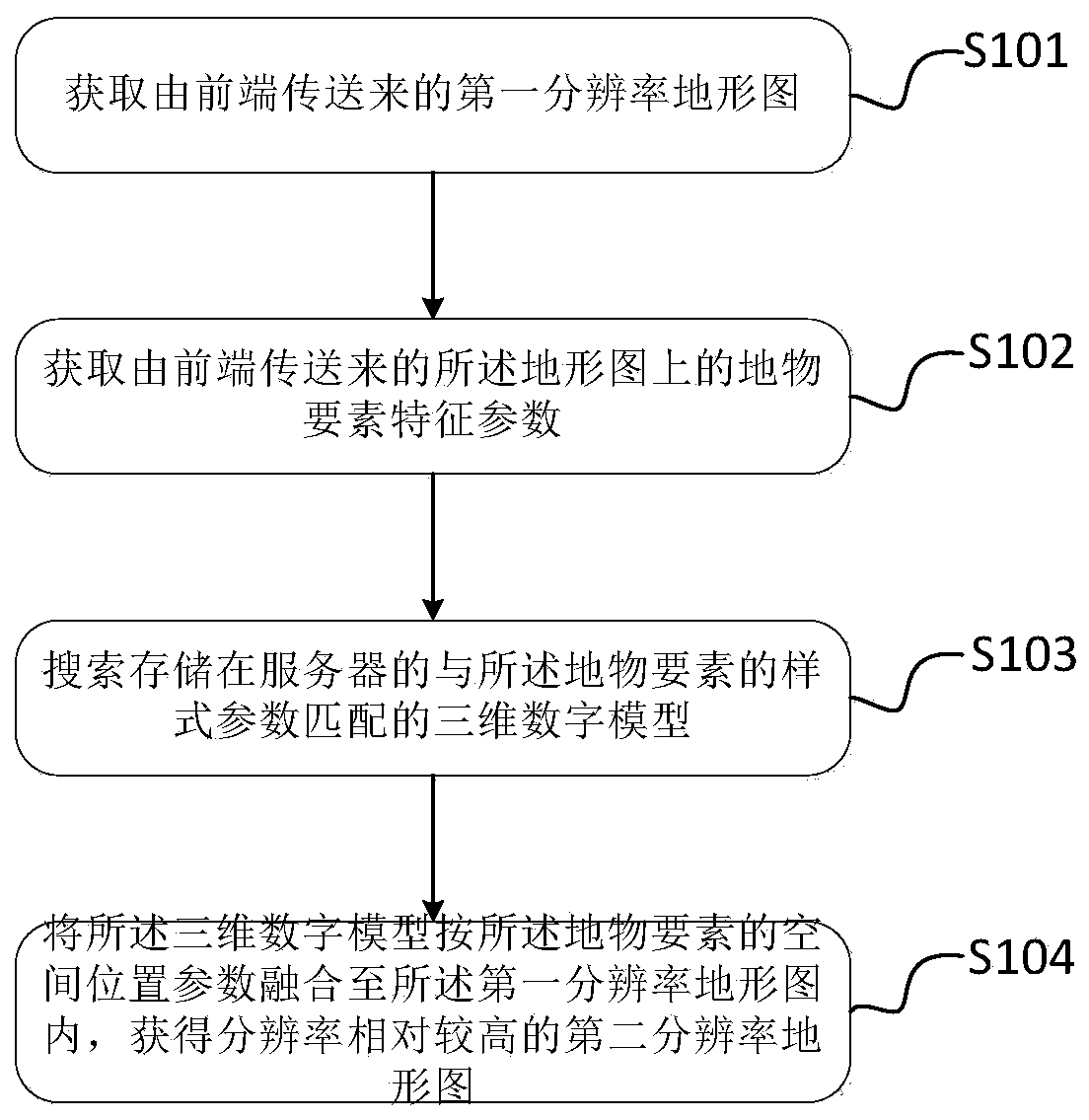
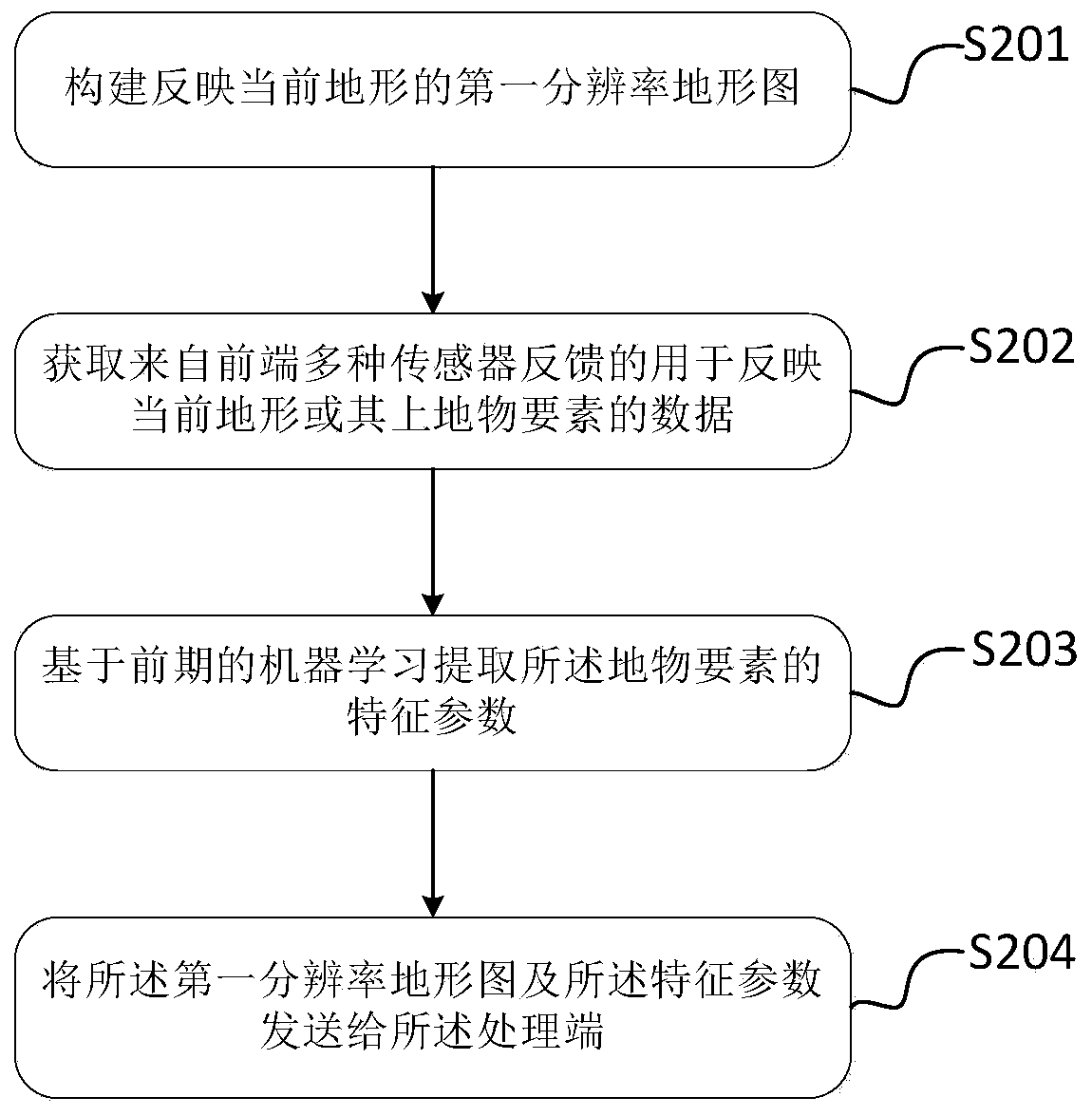
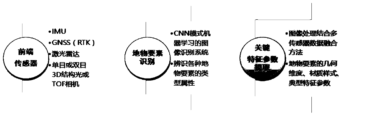
[0061]In order to make the objectives, technical solutions and advantages of the implementation of the application clearer, the technical solutions in the implementation modes of the application will be described in more detail below with reference to the drawings in the implementation modes of the application. In the drawings, the same or similar reference numerals denote the same or similar elements or elements having the same or similar functions throughout. The described embodiments are some, but not all, embodiments of the present application. The embodiments described below by referring to the figures are exemplary and are intended to explain the present application, and should not be construed as limiting the present application. Based on the implementation manners in this application, all other implementation manners obtained by persons of ordinary skill in the art without creative efforts fall within the scope of protection of this application. Embodiments of the pre...


PUM


Abstract

The invention provides a three-dimensional real-time map construction method and device. The method applied to a processing end comprises the steps of: obtaining a first resolution topographic map transmitted by a front end; acquiring feature parameters of ground object elements on the topographic map transmitted by a front end, wherein the feature parameters of the ground object elements comprisespatial position parameters and style parameters of the ground object elements; searching a three-dimensional digital model which is stored in a server and is matched with the style parameters of theground object elements; and fusing the three-dimensional digital model into the first resolution topographic map according to the spatial position parameters of the ground object elements to obtain asecond resolution topographic map with relatively high resolution. When the processing end constructs the three-dimensional real-time map, the front end only needs to adopt the image identification system trained on the ground in the earlier stage to automatically identify the key elements and extract the feature information of the elements, the characteristics of small information transmission data volume, large effective information amount and the like are achieved, and the map function requirement and the real-time requirement are met.

Description

technical field [0001] The present application belongs to the technical field of data processing, and in particular relates to a method and device for constructing a three-dimensional real-time map. Background technique [0002] The real-time situational awareness of the battlefield requires the reconnaissance system to perform real-time intelligent recognition of the acquired image information, and automatically identify key features such as buildings, military facilities, weapons and equipment through the analysis of the image by the artificial intelligence system, and can use image processing combined with multiple Sensor data fusion obtains the geometric dimensions of these elements, and identifies the types, functions, and typical performance parameters of military facilities and weaponry (such as radar types, antenna sizes, operating distances, and ranges, etc.). [0003] In order to provide command and decision-making with a more intuitive battlefield situation awaren...

Claims


Application Information

Patent Timeline
Patent Type & Authority Applications(China)
IPC IPC(8): G06T17/05
CPCG06T17/05
Inventor 程思野饶大林吴琴峰夏光荣
Owner AVIC HUADONG PHOTOELECTRIC SHENZHEN CO LTD
Why Eureka
Try Eureka