Coastal ship navigation simulation assistant decision-making method and system

A navigation aid and ship technology, applied in the field of coastal ship navigation simulation aid decision-making method and system, can solve the problems of high cost, single ranging position, manual arrangement of ranging devices, etc., so as to reduce the use of ranging equipment, reduce Computational complexity and the effect of improving computational efficiency

Pending Publication Date: 2020-05-15
智慧航海(青岛)科技有限公司
View PDF11 Cites 0 Cited by
  • Summary
  • Abstract
  • Description
  • Claims
  • Application Information

AI Technical Summary

Problems solved by technology

However, the error of the naked eye prediction is relatively large. When the ship is too close to the nearby land and there is a risk of collision, it cannot be warned in advance, and navigation is extremely dangerous; and purchasing a distance measuring device will cost a lot of money, and the distance measuring device Manual layout is required, which has certain complexity, and the distance measurement position is single, and it is impossible to flexibly measure the distance between the ship and the shore at any position in the established route
[0003] In the 3D simulation of ship navigation, it is very easy to automatically calculate the distance between two points, but it is impossible to automatically calculate the shortest distance between two larger objects, or between a point and a larger object. Therefore, in the simulation scene, quickly and accurately It is an urgent problem to be solved to automatically calculate the distance between the ship and the shore, and the distance between any position in the established route and the shore

Method used


Image

  • Coastal ship navigation simulation assistant decision-making method and system
  • Coastal ship navigation simulation assistant decision-making method and system
  • Coastal ship navigation simulation assistant decision-making method and system

Examples


Embodiment Construction

[0045] In order to better explain the present invention and facilitate understanding, the present invention will be described in detail below through specific embodiments in conjunction with the accompanying drawings.

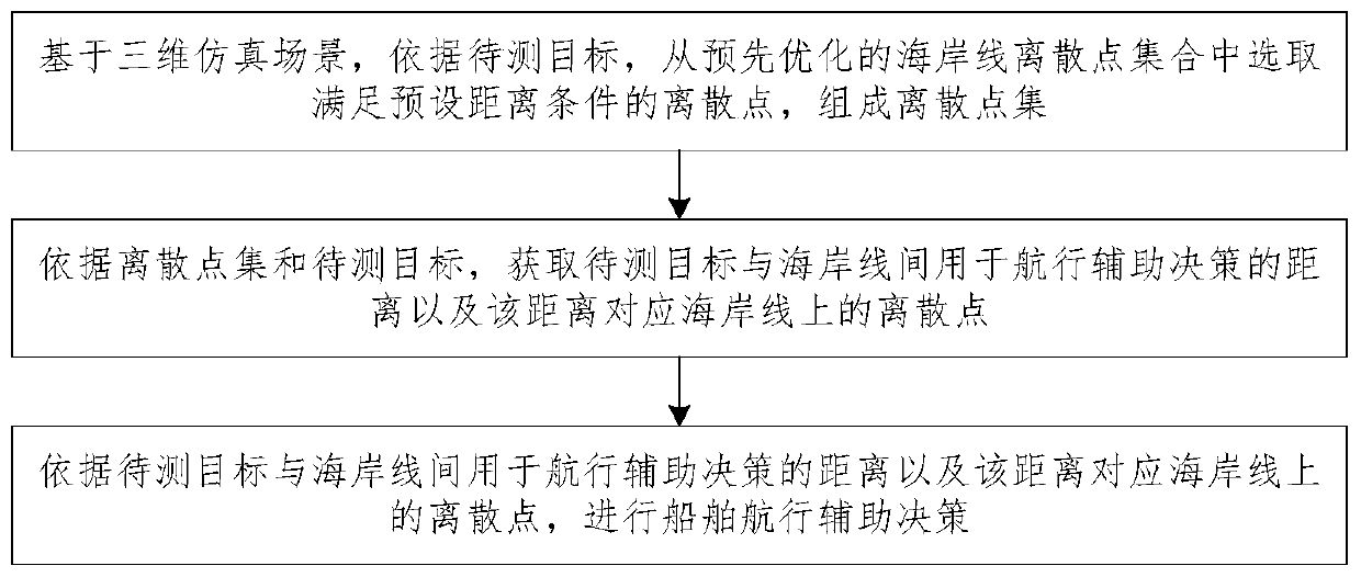
[0046] The invention provides a coastal ship navigation simulation auxiliary decision-making method, such as figure 1 shown, including the following steps:

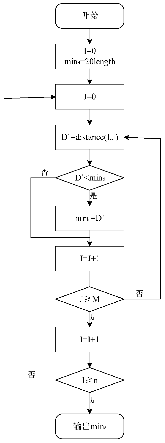
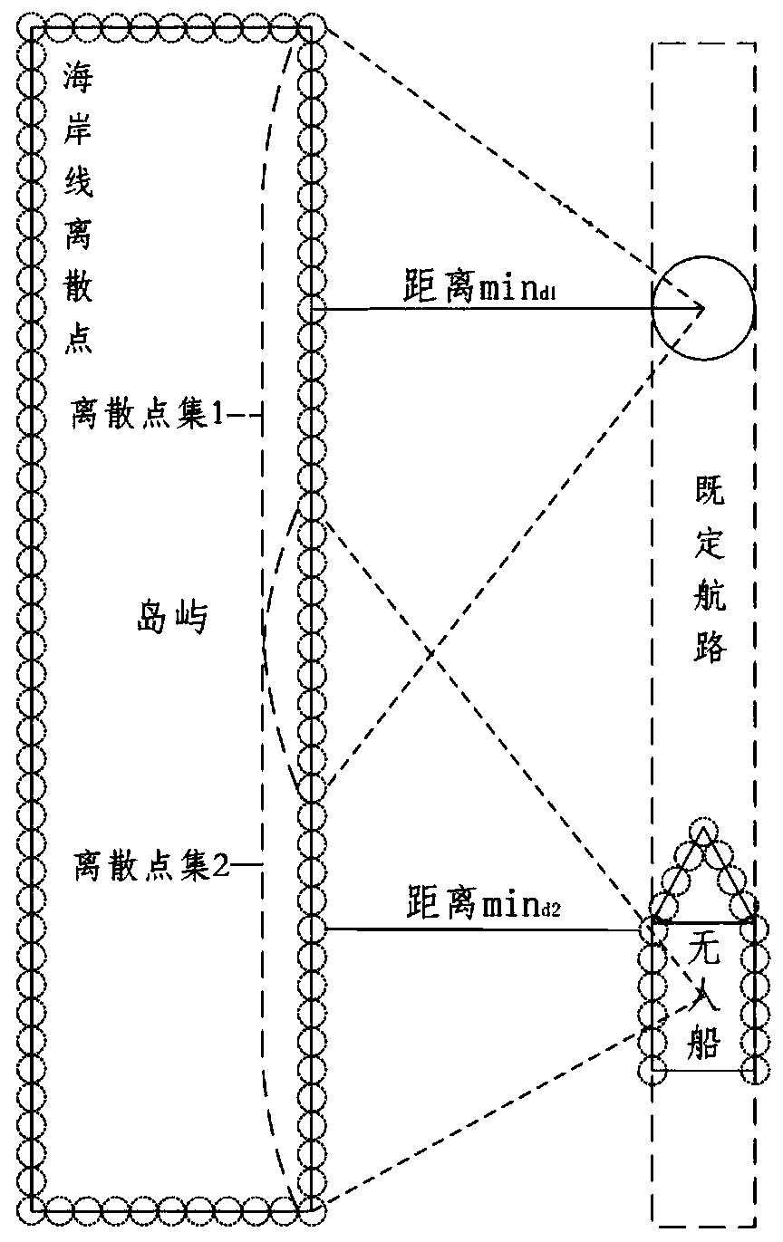
[0047] Step S1. Based on the three-dimensional simulation scene of coastal ship navigation, according to the target to be measured, select discrete points satisfying the preset distance condition from the optimized coastline discrete point set to form a discrete point set.

[0048] Specifically, the construction of the 3D simulation scene for coastal ship navigation includes: based on CAD 3D modeling technology, constructing 3D models of ports, docks, land, and islands around the ship's navigation sea area in the simulation scene; and correcting the 3D model based on electronic chart data. Test and optimi...


PUM


Abstract

The invention provides a coastal ship navigation simulation aid decision-making method, which comprises the steps of S1, selecting discrete points meeting a preset distance condition from a pre-optimized coastline discrete point set according to a to-be-measured target based on a three-dimensional simulation scene to form a discrete point set; and S2, according to the discrete point set and the to-be-measured target, obtaining a distance for navigation aid decision between the to-be-measured target and the coastline and discrete points on the coastline corresponding to the distance; and S3, performing ship navigation aid decision making according to the distance between the to-be-measured target and the coastline for navigation aid decision making and the discrete points on the coastline corresponding to the distance. The invention further provides a coastal ship navigation simulation auxiliary decision-making system. The system comprises a first storage unit, a processing unit and a foreground presentation unit. Therefore, the calculation of the shortest distance between two large objects or between a point and the large object is simpler and more accurate.

Description

technical field [0001] The invention relates to the technical field of auxiliary decision-making for ship navigation, in particular to a method and system for auxiliary decision-making of coastal ship navigation simulation. Background technique [0002] When a ship sails along the coast or sails at a port wharf, if the distance between the ship and the shore is too close, the risk of collision is very likely to occur. At present, during the ship's navigation, the distance can be measured through the naked eye prediction and distance measuring device, where the distance measuring device includes laser distance measuring sensor, ultrasonic technology and GPS. However, the error of the naked eye prediction is relatively large. When the ship is too close to the nearby land and there is a risk of collision, it cannot be warned in advance, and navigation is extremely dangerous; and purchasing a distance measuring device will cost a lot of money, and the distance measuring device ...

Claims


Application Information

Patent Timeline
IPC IPC(8): G06F30/20G06F111/10
Inventor 王晓原夏媛媛姜雨函袁如意万倩男朱慎超
Owner 智慧航海(青岛)科技有限公司
Why Eureka
Try Eureka