Karst water layered judgment and underground water level observation method
A groundwater level, karst water technology, applied in the direction of measuring devices, liquid/fluid solid measurement, level indicators of level members, etc., can solve mixed water and stratified water unclear, a lot of manpower and time costs, plugging scheme and process complexity, to achieve good scalability and reproducibility, reduce costs, improve convenience and flexibility
- Summary
- Abstract
- Description
- Claims
- Application Information
AI Technical Summary
Problems solved by technology
Method used
Image
Examples
Embodiment 1
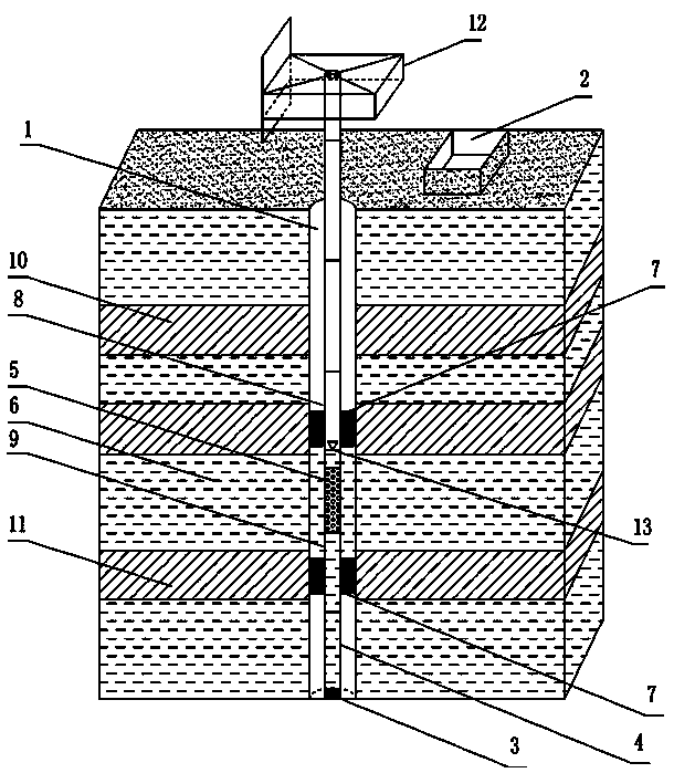
[0051] Such as figure 1 As shown, the karst water layer discrimination and groundwater level observation method of the present invention are now illustrated with the geological structure of four water-bearing layers as an example:
[0052] Step 1. According to the karst water stratification layer initially judged by the groundwater monitoring instrument, the exploration hole construction is adopted, and the drilling scale of each round is set to 3.0m. At the end of the drilling fluid return water volume data, calculate the drilling fluid loss for each return through the drilling fluid return water volume data, convert the loss data into the loss per unit meter, record the loss per unit meter data and plot the per unit meter Leakage data change curve; the specific steps are as follows:
[0053] Step 1.1, set up a backwater pool 2 next to the exploration hole 1, and set a scale in the backwater pool 2 from bottom to top, and the scale is used to measure the volume data of the d...
Embodiment 2
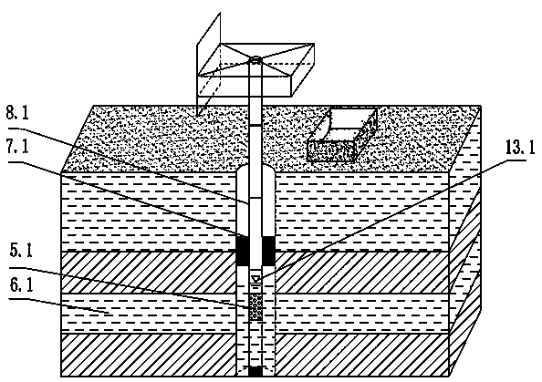
[0083] Such as figure 2 Shown is the geological structure of the karst water layer in the present invention divided into two water-bearing layers. The difference between the implementation steps and the embodiment 1 is that the number of pressurized water plugs 7.1 used is one. The target aquifer 6.1 that needs to be observed in this embodiment is the second layer, and the upper and lower parts of the second layer are relative aquifers. Therefore, it is only necessary to connect the drill with the pressure water plug 7.1 at the upper end of the drill pipe section 5.1 of the permeable hole. The pole section 8.1 can complete the observation of the stable water level 13.1 of the target aquifer 6.1.
PUM
 Abstract
Description
Claims
Application Information
 - R&D
- Intellectual Property
- Life Sciences
- Materials
- Tech Scout
- Unparalleled Data Quality
- Higher Quality Content
- 60% Fewer Hallucinations
Browse by: Latest US Patents, China's latest patents, Technical Efficacy Thesaurus, Application Domain, Technology Topic, Popular Technical Reports.
© 2025 PatSnap. All rights reserved.Legal|Privacy policy|Modern Slavery Act Transparency Statement|Sitemap|About US| Contact US: help@patsnap.com


