Method and system for extracting building roof points from airborne laser radar point clouds

An airborne lidar, building technology, applied in computer parts, character and pattern recognition, instruments, etc., can solve the problems of low execution efficiency and high computational complexity, and achieve the effect of improving accuracy

Active Publication Date: 2020-05-29
飞燕航空遥感技术有限公司
View PDF8 Cites 6 Cited by
  • Summary
  • Abstract
  • Description
  • Claims
  • Application Information

AI Technical Summary

Problems solved by technology

[0008] Purpose of the invention: the present invention aims to solve the problem of high computational complexity and low execution efficiency when using the RANSAC method to extract building plane

Method used


Image

  • Method and system for extracting building roof points from airborne laser radar point clouds
  • Method and system for extracting building roof points from airborne laser radar point clouds
  • Method and system for extracting building roof points from airborne laser radar point clouds

Examples


Embodiment Construction

[0041] The present invention will be further explained below in conjunction with the accompanying drawings and specific embodiments.

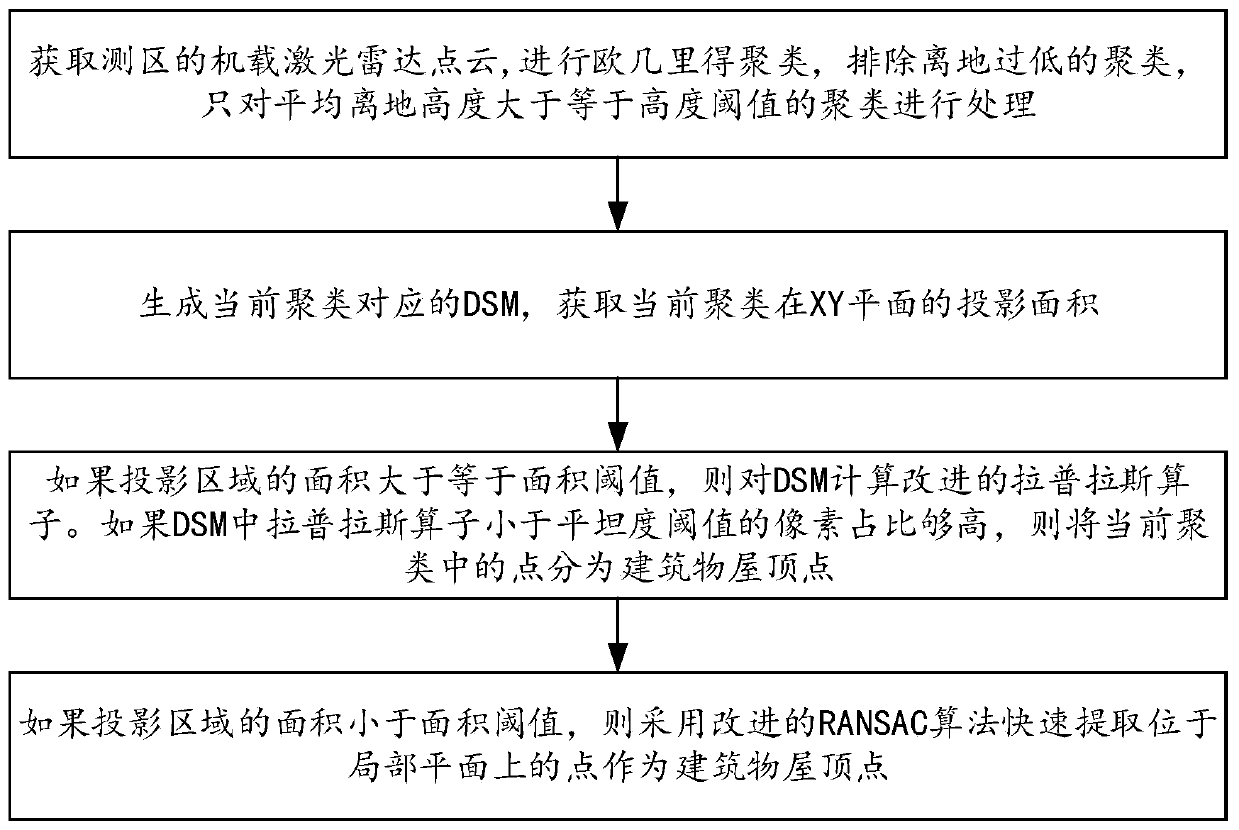
[0042] Such as figure 1 As shown, the present invention discloses a method for extracting building roof points from an airborne lidar point cloud, including:

[0043] Step 1. Obtain the airborne lidar point cloud of the survey area; use three-dimensional Euclidean clustering to cluster the obtained point cloud; calculate the average height of the point cloud in each cluster, and calculate the average ground height Each cluster whose height is greater than the height threshold is processed according to steps 2-4 to extract building roof points;

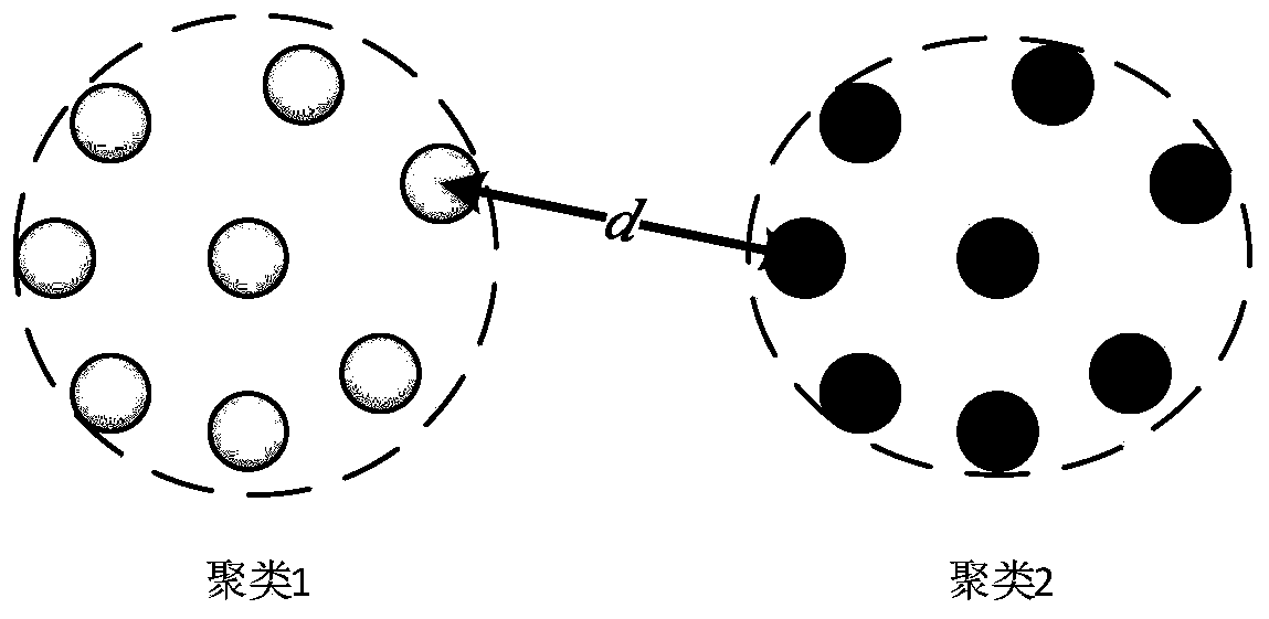
[0044] Such as figure 2 As shown, the result of Euclidean clustering is to make the minimum distance d between different clusters greater than or equal to the search radius R. The parameters of the Euclidean clustering algorithm include: search radius R, cluster minimum point threshold N min , Clus...


PUM


Abstract

The invention discloses a method and system for extracting building roof points from airborne laser radar point cloud. According to the method for extracting the building roof points, airborne laser radar point clouds in a measurement area are segmented into a plurality of clusters through three-dimensional Euclidean clustering; a Laplace operator of the DSM for the cluster with a larger area is calculated, and if the proportion of pixels of which the Laplace operator is smaller than a flatness threshold value is high, points in the cluster are divided into building roof points; for clusteringwith a small area, an improved RANSAC algorithm is adopted to extract points on the roof of a building. According to the method, the problems of high calculation complexity and low execution efficiency when the building plane roof points are extracted can be solved, the non-building tree points can be prevented from being classified into the building roof points, and the building roof point extraction efficiency and accuracy are improved.

Description

technical field [0001] The invention belongs to the technical field of airborne lidar point cloud data processing, in particular to a method and system for extracting points falling on building roofs from airborne lidar point clouds. Background technique [0002] Airborne LiDAR (Light Detection And Ranging, laser radar) is one of the most efficient and fastest-growing large-area surveying and mapping methods in the current surveying and mapping field. By using the laser to emit and receive high-energy laser pulses to measure distance, the GNSS (Global Navigation Satellite System, Global Navigation Satellite System) receiver gives the real-time position of the laser, and the INS (Inertial Navigation System, inertial navigation system) gives the real-time three-dimensional attitude of the laser. The three-dimensional coordinates of the scattering surface can be calculated by vector formula and coordinate conversion. With the help of mechanical scanning device, airborne LiDAR ...

Claims


Application Information

Patent Timeline
IPC IPC(8): G06K9/00G06K9/62
CPCG06V20/176G06F18/23
Inventor 程晓光
Owner 飞燕航空遥感技术有限公司
Why Eureka
Try Eureka